
Fatehpur Chaurasi
Fatehpur Chaurasi | |
|---|---|
city | |
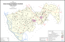 Map of Fatehpur Chaurasi CD block | |
 Fatehpur Chaurasi Location in Uttar Pradesh, India | |
| Coordinates: 26°47′00″N 80°16′30″E / 26.7833°N 80.275°E | |
| Country | |
| State | Uttar Pradesh |
| District | Unnao |
| Area | |
| • Total | 2 km2 (0.8 sq mi) |
| Population (2011)[1] | |
| • Total | 6,715 |
| • Density | 3,400/km2 (8,700/sq mi) |
| Languages | |
| • Official | Hindi |
| Time zone | UTC+5:30 (IST) |
| Vehicle registration | UP |
| Website | up |

Fatehpur Chaurasi is a town and a nagar panchayat in Unnao district in the state of Uttar Pradesh, India.[1] First officially classified as a town for the 1981 census,[2] Fatehpur Chaurasi is located on the north bank of the , a bit to the south of the main road from Unnao to Bangarmau.[3] Local industries include the production of furniture, boxes, almirahs, shoes, and slippers.[1] As of 2011, the town's population is 6,715, in 1,158 households.[1]
Demographics[]
| Year | Pop. | ±% |
|---|---|---|
| 1981 | 3,407 | — |
| 1991 | 4,242 | +24.5% |
| 2001 | 5,417 | +27.7% |
| 2011 | 6,715 | +24.0% |
| Source: 2011 Census of India[1] | ||
According to the 2001 census,[4] Fatehpur Chaurasi had a population of 5424. Males constitute 53% of the population and females 47%. Fatehpur Chaurasi has an average literacy rate of 52%, lower than the national average of 59.5%: male literacy is 60%, and female literacy is 44%. In Fatehpur Chaurasi, 17% of the population is under 6 years of age.
According to the 2011 census, Fatehpur Chaurasi has a population of 6,715 people, in 1,158 households.[1] The town's sex ratio is 892 females to every 1000 males; 3,550 of Fatehpur Chaurasi's residents are male and 3,165 are female.[1] Among the 0-6 age group, the sex ratio is 955, which is higher than the district urban average.[1] Members of Scheduled Castes make up 7.3% of the town's population, while no members of scheduled tribes were recorded.[1] The town's literacy rate was 70.1% (counting only people age 7 and up); literacy was higher among men and boys (78.6%) than among women and girls (60.4%).[1]
In terms of employment, 18.0% of Fatehpur Chaurasi residents were classified as main workers (i.e. people employed for at least 6 months per year) in 2011.[1] Marginal workers (i.e. people employed for less than 6 months per year) made up 10.4%, and the remaining 71.6% were non-workers.[1] Employment status varied heavily according to gender, with 45.7% of men being either main or marginal workers, compared to only 9.0% of women.[1]
Education[]
Fatehpur chaurasi has a Jawahar Navodaya Vidyalaya, where students of different parts of the district of unnao come to study
Office[]
Fatehpur chaurasi has a Sarkari Result Head Office [1], where students of different parts of the district of unnao come to get help
Villages[]
Fatehpur Chaurasi CD block has the following 116 villages:[1]
| Village name | Total land area (hectares) | Population (in 2011) |
|---|---|---|
| 123 | 403 | |
| 116 | 348 | |
| 279.6 | 1,478 | |
| 310.3 | 2,945 | |
| 230.8 | 635 | |
| 87.7 | 1,401 | |
| 298 | 1,212 | |
| 220.1 | 408 | |
| 177 | 0 | |
| 112 | 0 | |
| 218.8 | 590 | |
| 62.1 | 660 | |
| 196 | 1,978 | |
| 192.2 | 440 | |
| 198.8 | 467 | |
| 62.3 | 0 | |
| 74.7 | 275 | |
| 186.9 | 1,043 | |
| 377.3 | 2,218 | |
| 1,576.6 | 2,472 | |
| 131.3 | 0 | |
| 20.7 | 0 | |
| 111.2 | 0 | |
| 451.9 | 4,678 | |
| 324.6 | 1,226 | |
| 223.6 | 886 | |
| 130.2 | 387 | |
| 130.7 | 638 | |
| 94 | 1,138 | |
| 100.9 | 0 | |
| 119.5 | 0 | |
| 133.2 | 781 | |
| 103.6 | 542 | |
| 305 | 3,856 | |
| 219.6 | 1,309 | |
| 98 | 400 | |
| 523.2 | 0 | |
| 423.7 | 0 | |
| 207.5 | 1,151 | |
| 174.9 | 848 | |
| 181.5 | 1,256 | |
| 91.6 | 632 | |
| 113.4 | 771 | |
| 38.3 | 209 | |
| 139.9 | 1,162 | |
| 81.8 | 640 | |
| 262.6 | 1,560 | |
| 67.5 | 384 | |
| 94.6 | 1,185 | |
| 58.3 | 507 | |
| 80.3 | 776 | |
| 766.9 | 3,807 | |
| 315 | 2,206 | |
| 134.3 | 1,160 | |
| 210.4 | 1,048 | |
| 160 | 840 | |
| 132.1 | 1,229 | |
| 177.5 | 985 | |
| 94.4 | 958 | |
| 131.7 | 1,014 | |
| 285 | 2,092 | |
| 19.2 | 0 | |
| 94.5 | 400 | |
| 156 | 793 | |
| 188.2 | 942 | |
| 184.3 | 1,214 | |
| 196.9 | 1,477 | |
| 194.2 | 970 | |
| 146 | 435 | |
| 131.7 | 691 | |
| 279.6 | 2,487 | |
| 272 | 1,868 | |
| 1,025.2 | 5,462 | |
| 234.7 | 1,370 | |
| 387.4 | 2,234 | |
| 316.6 | 1,689 | |
| 142 | 1,022 | |
| 172.8 | 1,680 | |
| 99.2 | 506 | |
| 168.6 | 914 | |
| 152.9 | 1,483 | |
| 155.2 | 1,006 | |
| Sadullapur | 308.8 | 1,064 |
| 154.3 | 751 | |
| 922.5 | 3,531 | |
| 236.5 | 1,106 | |
| 158.8 | 1,061 | |
| 208.1 | 1,114 | |
| 102.8 | 851 | |
| 1,120.9 | 1,204 | |
| 479.7 | 3,124 | |
| 231.8 | 2,496 | |
| 98.2 | 686 | |
| 61.4 | 458 | |
| 33.7 | 1,041 | |
| 128.1 | 820 | |
| 142.7 | 1,201 | |
| 175.2 | 2,090 | |
| 272.2 | 540 | |
| 503.4 | 6,136 | |
| 44.7 | 1,355 | |
| 125.3 | 958 | |
| 91.9 | 1,255 | |
| 110.6 | 1,991 | |
| 73.7 | 1,522 | |
| 78.4 | 70 | |
| 588 | 5,175 | |
| 560.8 | 1,812 | |
| 509.1 | 808 | |
| 211.2 | 636 | |
| 189.4 | 2,187 | |
| 167.4 | 1,631 | |
| 218.6 | 1,141 | |
| 1,225.6 | 6,257 | |
| 213.4 | 1,283 | |
| 735.1 | 3,978 |
References[]
- ^ a b c d e f g h i j k l m n o "Census of India 2011: Uttar Pradesh District Census Handbook - Unnao, Part A (Village and Town Directory)". Census 2011 India. pp. 36–55, 110–34, 525–39. Retrieved 29 June 2021.
- ^ Census 1981 Uttar Pradesh: District Census Handbook Part XIII-A: Village & Town Directory, District Unnao (PDF). 1982. p. 15. Retrieved 29 June 2021.
- ^ Nevill, H.R. (1903). Unao: A Gazetteer, Being Volume XXXVIII Of The District Gazetteers Of The United Provinces Of Agra And Oudh. Allahabad: Government Press. pp. 171–5. Retrieved 29 June 2021.
- ^ "Census of India 2001: Data from the 2001 Census, including cities, villages and towns (Provisional)". Census Commission of India. Archived from the original on 16 June 2004. Retrieved 1 November 2008.
This Unnao district location article is a stub. You can help Wikipedia by . |
- Cities and towns in Unnao district
- Lucknow division geography stubs