Hilauli
Hilauli | |
|---|---|
Village | |
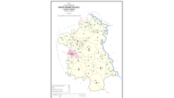 Map of Hilauli CD block | |
 Hilauli Location in Uttar Pradesh, India | |
| Coordinates: 26°27′17″N 80°56′25″E / 26.45485°N 80.940234°ECoordinates: 26°27′17″N 80°56′25″E / 26.45485°N 80.940234°E[1] | |
| Country India | |
| State | Uttar Pradesh |
| District | Unnao |
| Area | |
| • Total | 23.122 km2 (8.927 sq mi) |
| Population (2011)[2] | |
| • Total | 13,318 |
| • Density | 580/km2 (1,500/sq mi) |
| Languages | |
| • Official | Hindi |
| Time zone | UTC+5:30 (IST) |
| Vehicle registration | UP-35 |

Hilauli is a village in Purwa tehsil of Unnao district, Uttar Pradesh, India.[2] It is located on the road from Maurawan to Bachhrawan in Rae Bareli district, near the banks of the Sai.[3] Hilauli hosts a market twice per week, on Wednesdays and Thursdays, with grain and vegetables being the main items bought and sold.[4] As of 2011, the population of Hilauli is 13,318, in 2,533 households.[2]
Hilauli also serves as the headquarters of a community development block, which encompasses 68 villages (including Hilauli itself) and has a total population of 178,460 people in 32,880 households.[2]
History[]
According to oral tradition, Hilauli was founded by two Kayasths named Hanuman and Banwari.[3] Folklore holds that the field of Madhab, a Thakur who once lived here, never needs irrigation, no matter how dry the weather gets.[3] Hilauli historically lay in the pargana of Maurawan.[3]
At the turn of the 20th century, Hilauli was described as "a very large village... pleasantly situated among mango groves in a sandy soil near the river Sai".[3] It hosted "a considerable market" twice per week, and it had one school and a small mosque.[3] Its population in 1901 was 4,340, with a large Chhatri population and a small Muslim minority of 260.[3]
The 1961 census recorded Hilauli as comprising 16 hamlets, with a total population of 5,594 (2,801 male and 2,793 female), in 960 households and 860 physical houses.[4] The area of the village was given as 6,055 acres.[4] Average attendance of the biweekly market was about 200 people.[4]
Villages[]
Hilauli CD block has the following 68 villages:[2]
| Village name | Total land area (hectares) | Population (in 2011) |
|---|---|---|
| Deomai | 825.3 | 3,673 |
| 412.3 | 2,367 | |
| 233.1 | 1,464 | |
| 80.6 | 952 | |
| 390 | 3,224 | |
| 193 | 1,142 | |
| 179.9 | 2,147 | |
| Sagauli | 269 | 2,048 |
| 343 | 1,497 | |
| Bachhaura | 364.6 | 2,607 |
| 275.2 | 1,835 | |
| 337.7 | 1,909 | |
| Bhatan Khera | 139.6 | 820 |
| 197 | 1,570 | |
| 218 | 641 | |
| Bathua Shahpur | 76.8 | 590 |
| 176 | 1,151 | |
| Basdeo Khera | 47.8 | 103 |
| Para | 1,623.2 | 7,701 |
| Sarai Thakuri | 115 | 671 |
| Mardanpur | 318.9 | 1,668 |
| Reola | 49.3 | 594 |
| Musandi | 277.5 | 2,992 |
| 952.6 | 4,335 | |
| Khajuha | 114.5 | 427 |
| Lohli | 135.9 | 827 |
| Chilauli | 299.1 | 1,148 |
| 147.4 | 1,110 | |
| Barenda | 200.4 | 864 |
| Asrenda | 632.5 | 4,475 |
| 272.7 | 2,404 | |
| Lauwasingan Khera | 2,023 | 9,984 |
| 108.9 | 883 | |
| Subas Khera | 89 | 810 |
| 167.4 | 1,042 | |
| 213.3 | 1,203 | |
| Maharani Khera | 460.2 | 2,683 |
| Hilauli (block headquarters) | 2,312.2 | 13,318 |
| Bardaha | 459.5 | 2,529 |
| Sandana | 891.1 | 6,082 |
| 510.7 | 3,873 | |
| 105.6 | 800 | |
| 443.1 | 1,525 | |
| 236.1 | 1,349 | |
| 185.8 | 1,265 | |
| 245.2 | 835 | |
| Mawai | 2,489 | 14,690 |
| 520.8 | 2,993 | |
| 213.3 | 1,503 | |
| 371.4 | 2,323 | |
| 53.7 | 172 | |
| 235.3 | 1,320 | |
| 151.2 | 397 | |
| 306.5 | 860 | |
| 635.9 | 3,252 | |
| Lachhi Khera | 503.4 | 1,488 |
| 1,005.5 | 2,093 | |
| 314.9 | 1,428 | |
| 153.7 | 375 | |
| 136.4 | 809 | |
| Jera | 518.1 | 2,826 |
| 204.2 | 1,205 | |
| 2,614.6 | 13,167 | |
| Nari Chak | 520.9 | 2,129 |
| 495.8 | 2,838 | |
| Lotna | 493.2 | 2,443 |
| 254.5 | 530 | |
| Gulriha | 2,451.8 | 12,482 |
References[]
- ^ Search for "Hilauli" here https://geonames.nga.mil/namesgaz/. Missing or empty
|title=(help) - ^ a b c d e f "Census of India 2011: Uttar Pradesh District Census Handbook - Unnao, Part A (Village and Town Directory)". Census 2011 India. pp. 373–89. Retrieved 11 July 2021.
- ^ a b c d e f g Nevill, H.R. (1903). Unao: A Gazetteer, Being Volume XXXVIII Of The District Gazetteers Of The United Provinces Of Agra And Oudh. Allahabad: Government Press. p. 187. Retrieved 11 July 2021.
- ^ a b c d Census 1961: District Census Handbook, Uttar Pradesh (37 - Unnao District) (PDF). Lucknow. 1965. pp. 158, cxiv-cxv of section "Purwa Tehsil". Retrieved 11 July 2021.
- Villages in Unnao district
- Community development blocks in India