Hasanganj
Hasanganj | |
|---|---|
Village | |
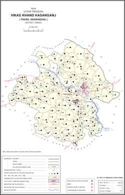 Map of Hasanganj CD block | |
 Hasanganj Location in Uttar Pradesh, India | |
| Coordinates: 26°46′28″N 80°38′14″E / 26.774499°N 80.637114°ECoordinates: 26°46′28″N 80°38′14″E / 26.774499°N 80.637114°E[1] | |
| Country India | |
| State | Uttar Pradesh |
| District | Unnao |
| Area | |
| • Total | 1.838 km2 (0.710 sq mi) |
| Population (2011)[2] | |
| • Total | 4,658 |
| • Density | 2,500/km2 (6,600/sq mi) |
| Languages | |
| • Official | Hindi |
| Time zone | UTC+5:30 (IST) |
| Vehicle registration | UP-35 |

Hasanganj is a village and tehsil headquarters in Unnao district of Uttar Pradesh, India.[2] It is located near Mohan, at a road junction leading to Miyanganj and .[3] As of 2011, its population is 4,658, in 818 households.[2]
Hasanganj hosts two fairs: the Jal Bihar cattle fair on Bhadra Badi 2-4, and the fair on Bhadra Sudi 3.[4] At both events, vendors bring sweets, clay toys, and articles of daily use to sell.[4] Hasanganj also holds a market on Tuesdays and Fridays where grain and vegetables are sold.[4]
History[]
Hasanganj was originally a bazaar founded by Hasan Raza Khan, a naib in the service of Asaf-ud-Daula, in the village of Mahadeopur Balamau.[3] It became a tehsil headquarters around 1890, replacing Mohan in this capacity, and the police station was transferred to Hasanganj at the same time.[3]
At the turn of the 20th century, Hasanganj was centred around "a wide street lined with trees and shops on both sides."[3] It was a minor commercial centre and had, in addition to the tehsil office and police station, a dispensary and a road bungalow, as well as an upper primary school with 32 students.[3] Most of the locals were Banias and agriculturalists, and the population in 1901 was 1,310, including a Muslim minority of 255 people.[3]
The 1961 census recorded Hasanganj as comprising 3 hamlets, with a total population of 1,461 (828 male and 633 female), in 268 households and 245 physical houses.[4] The area of the village was given as 318 acres.[4] Average attendance of the biweekly market was about 400.[4] Average attendance at both the Jal Bihar and Kans Lila fairs was recorded as 2,000 people.[4] The police station had a staff of 2 sub-inspectors, 1 head constable, and 14 constables at the time.[4]
Villages[]
Hasanganj CD block has the following 156 villages:[2]
| Village name | Total land area (hectares) | Population (in 2011) |
|---|---|---|
| 235.8 | 1,260 | |
| 750.7 | 4,880 | |
| 131.7 | 938 | |
| 322.4 | 1,048 | |
| 200.8 | 1,610 | |
| 150.4 | 1,193 | |
| 87.4 | 573 | |
| 79.9 | 462 | |
| 111.3 | 612 | |
| 89.5 | 0 | |
| 398 | 1,036 | |
| 154.1 | 1,572 | |
| 464.1 | 1,081 | |
| 191.4 | 1,227 | |
| 301.6 | 1,738 | |
| 55.7 | 948 | |
| Dhaora | 738.5 | 4,333 |
| 663.1 | 3,025 | |
| 307.5 | 471 | |
| 39 | 285 | |
| 335.6 | 999 | |
| 520.8 | 1,848 | |
| 649.2 | 2,041 | |
| 237.4 | 0 | |
| 120.3 | 951 | |
| 277.3 | 0 | |
| 119.5 | 417 | |
| 258.4 | 4,476 | |
| 29.6 | 330 | |
| 30.8 | 0 | |
| 322 | 1,573 | |
| 11.9 | 0 | |
| 143.3 | 916 | |
| 10.1 | 0 | |
| 81.2 | 0 | |
| 155.6 | 0 | |
| 169.8 | 1,178 | |
| 157.4 | 698 | |
| 181.4 | 829 | |
| 695.3 | 2,408 | |
| 217.7 | 798 | |
| 472.3 | 2,153 | |
| 125.2 | 1,522 | |
| 64.5 | 0 | |
| 518.2 | 3,144 | |
| 46.7 | 0 | |
| 83.2 | 1,250 | |
| 200.5 | 900 | |
| Hasanganj (block headquarters) | 183.8 | 4,658 |
| 45.7 | 560 | |
| 46.6 | 0 | |
| 29.5 | 191 | |
| 368.9 | 1,843 | |
| 115 | 707 | |
| 26.3 | 0 | |
| 193.2 | 1,132 | |
| 72.6 | 238 | |
| 139.9 | 1,226 | |
| 375.1 | 2,189 | |
| 152.6 | 716 | |
| 171.6 | 871 | |
| 168.4 | 621 | |
| 131 | 1,022 | |
| 159.6 | 1,038 | |
| 144.1 | 891 | |
| 63.1 | 0 | |
| 181.5 | 1,518 | |
| 137.6 | 849 | |
| 462.3 | 2,815 | |
| 122 | 791 | |
| 122.4 | 815 | |
| 137.6 | 1,184 | |
| 52.3 | 461 | |
| 145.5 | 1,037 | |
| 156.3 | 694 | |
| 106.2 | 864 | |
| 220.9 | 2,032 | |
| 135.2 | 789 | |
| 63 | 432 | |
| 124 | 1,108 | |
| 85.8 | 609 | |
| 341.7 | 3,132 | |
| 153.5 | 1,159 | |
| 55.8 | 179 | |
| 187.1 | 1,335 | |
| 55.7 | 101 | |
| 348 | 2,388 | |
| 135 | 681 | |
| 108.7 | 370 | |
| 319.3 | 1,725 | |
| 147.1 | 1,218 | |
| 123.3 | 1,057 | |
| 202 | 1,092 | |
| 555 | 3,718 | |
| 154.5 | 1,163 | |
| 79.2 | 1,238 | |
| 489.6 | 3,430 | |
| 66.6 | 409 | |
| 206.1 | 1,470 | |
| 192.3 | 978 | |
| 126.6 | 358 | |
| 476.5 | 1,682 | |
| 135.8 | 836 | |
| 235.6 | 755 | |
| 160.7 | 1,214 | |
| Sandana | 538.7 | 2,583 |
| 427 | 2,355 | |
| 24.7 | 239 | |
| 240.1 | 1,793 | |
| 140.2 | 493 | |
| 320 | 1,168 | |
| 207.6 | 1,112 | |
| 300.7 | 1,048 | |
| 299.2 | 1,432 | |
| 148.8 | 912 | |
| 221 | 1,123 | |
| 84.2 | 581 | |
| 150.2 | 545 | |
| Jhalotar | 177.7 | 1,990 |
| 464.3 | 3,085 | |
| 75.4 | 350 | |
| 3 | 517 | |
| 168.8 | 1,015 | |
| 133.6 | 209 | |
| 101.3 | 0 | |
| 32.3 | 0 | |
| 151.3 | 38 | |
| 152.6 | 0 | |
| 195.9 | 667 | |
| 29.6 | 464 | |
| 22.1 | 280 | |
| 128.8 | 1,106 | |
| 128.6 | 226 | |
| 268.7 | 1,178 | |
| 353 | 1,859 | |
| 168.7 | 1,352 | |
| 168.7 | 1,551 | |
| 112.9 | 667 | |
| 98.7 | 818 | |
| 60.8 | 479 | |
| 90.1 | 562 | |
| 101.5 | 1,186 | |
| 369.5 | 1,998 | |
| 120.1 | 509 | |
| 275.6 | 2,086 | |
| 172.3 | 1,181 | |
| 77.4 | 733 | |
| 74.5 | 537 | |
| 118.2 | 633 | |
| 135.2 | 733 | |
| 141.2 | 1,384 | |
| 257.7 | 1,741 | |
| 38.3 | 273 | |
| 205.9 | 947 | |
| 84.2 | 646 | |
| 128.5 | 1,341 |
References[]
- ^ Search for "Hasanganj" here https://geonames.nga.mil/namesgaz/. Missing or empty
|title=(help) - ^ a b c d e "Census of India 2011: Uttar Pradesh District Census Handbook - Unnao, Part A (Village and Town Directory)". Census 2011 India. pp. 204–36. Retrieved 2 July 2021.
- ^ a b c d e f Nevill, H.R. (1903). Unao: A Gazetteer, Being Volume XXXVIII Of The District Gazetteers Of The United Provinces Of Agra And Oudh. Allahabad: Government Press. pp. 186–7. Retrieved 2 July 2021.
- ^ a b c d e f g h Census 1961: District Census Handbook, Uttar Pradesh (37 - Unnao District) (PDF). Lucknow. 1965. pp. 127, 152–3, 157, lii-liii of section "Hasanganj Tehsil". Retrieved 2 July 2021.
- Villages in Unnao district