Francillon-sur-Roubion
Francillon-sur-Roubion | |
|---|---|
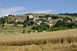 A general view of Francillon-sur-Roubion | |
show Location of Francillon-sur-Roubion | |
 Francillon-sur-Roubion | |
| Coordinates: 44°37′29″N 5°05′14″E / 44.6247°N 5.0872°ECoordinates: 44°37′29″N 5°05′14″E / 44.6247°N 5.0872°E | |
| Country | France |
| Region | Auvergne-Rhône-Alpes |
| Department | Drôme |
| Arrondissement | Die |
| Canton | Dieulefit |
| Intercommunality | Val de Drôme en Biovallée |
| Government | |
| • Mayor (2020–2026) | Jean-Michel Gaudet |
| Area 1 | 10.8 km2 (4.2 sq mi) |
| Population (Jan. 2018)[1] | 191 |
| • Density | 18/km2 (46/sq mi) |
| Time zone | UTC+01:00 (CET) |
| • Summer (DST) | UTC+02:00 (CEST) |
| INSEE/Postal code | 26137 /26400 |
| Elevation | 287–651 m (942–2,136 ft) (avg. 462 m or 1,516 ft) |
| 1 French Land Register data, which excludes lakes, ponds, glaciers > 1 km2 (0.386 sq mi or 247 acres) and river estuaries. | |


Francillon-sur-Roubion (French pronunciation: [fʁɑ̃sijɔ̃ syʁ ʁubjɔ̃]; Occitan: Francilhon) is a commune in the Drôme department in the Auvergne-Rhône-Alpes region in southeastern France.
Population[]
| Year | Pop. | ±% |
|---|---|---|
| 1911 | 277 | — |
| 1962 | 114 | −58.8% |
| 1968 | 119 | +4.4% |
| 1975 | 122 | +2.5% |
| 1982 | 133 | +9.0% |
| 1990 | 124 | −6.8% |
| 1999 | 140 | +12.9% |
| 2008 | 175 | +25.0% |
See also[]
References[]
- ^ "Populations légales 2018". INSEE. 28 December 2020.
| Wikimedia Commons has media related to Francillon-sur-Roubion. |
| show Authority control |
|---|
This Drôme geographical article is a stub. You can help Wikipedia by . |
Categories:
- Communes of Drôme
- Drôme geography stubs