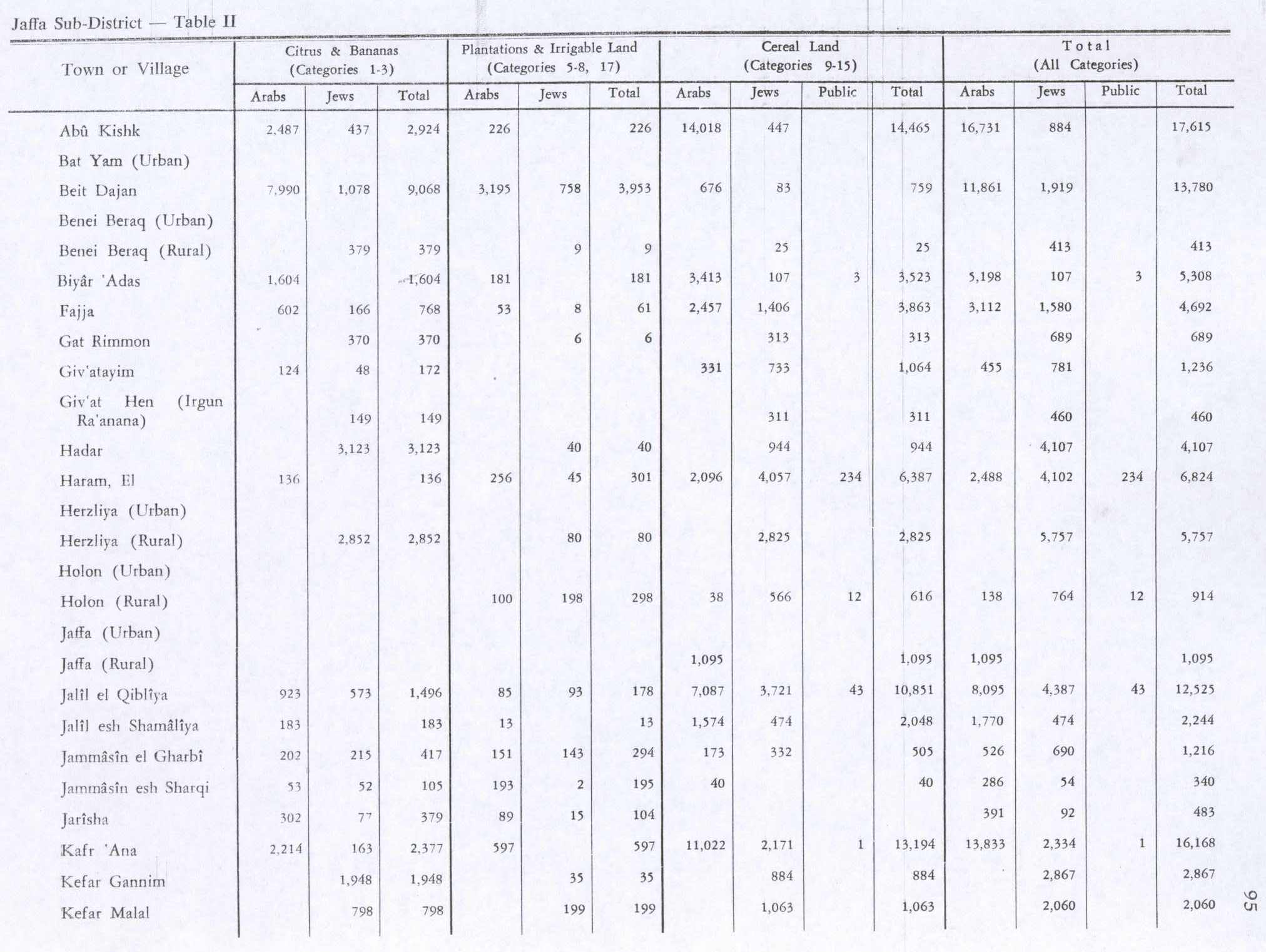
Jarisha
Jarisha
جرِيشة Jerisha, Jarush | |
|---|---|
 Old mill at Jarisha, about 1917 | |
| Etymology: Jerisheh, from "to pound" or "grind"[1] | |
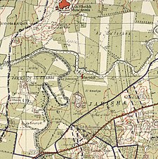 A series of historical maps of the area around Jarisha (click the buttons) | |
 Jarisha Location within Mandatory Palestine | |
| Coordinates: 32°5′43″N 34°48′28″E / 32.09528°N 34.80778°ECoordinates: 32°5′43″N 34°48′28″E / 32.09528°N 34.80778°E | |
| Palestine grid | 132/167 |
| Geopolitical entity | Mandatory Palestine |
| Subdistrict | Jaffa |
| Area | |
| • Total | 555 dunams (55.5 ha or 137 acres) |
| Population (1945) | |
| • Total | 190[2][3] |
| Current Localities | Yarkon Park, Tel Aviv,[4] Ramat Gan |
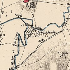
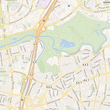
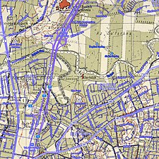

Jarisha (Arabic: جرِيشة, also transliterated Jerisha; Hebrew: ג'רישה) was a Palestinian Arab village located 200 meters (660 ft) from the ancient site of Tell Jarisha (Tel Gerisa), on the south bank of Al-Awja (Yarkon River).[5][6] After the establishment of Tel Aviv, it was one of five Arab villages to fall within its municipal boundaries.[4] Jarisha was ethnically cleansed in the lead up to the 1948 Arab-Israeli war, and the site has since been "completely covered over by highways and suburban houses."[6] Today, Yarkon Park covers the built up area of the village.
History[]
Jarisha was located only 200 meters (660 ft) from Tel Gerisa, an archaeological site dating to the Early Bronze II period (2800-2600 BC). In the Middle Bronze period (2000-1500 BC) the site was a fortified Hyksos town.[dubious ] It was succeeded by a Philistine settlement around the 12th century BC.[7]
Ottoman period[]
In the 1596 tax records under the Ottoman Empire, it was a village in the nahiya ("subdistrict") of the Bani Sa'b, part of Nablus Sanjak. It had a population of 22 Muslim households; an estimated 121 persons, who paid taxes on buffalo, goats and beehives; a total of 2,150 akçe.[8]
In 1856 the village was named Darishah on the map of Southern Palestine that Heinrich Kiepert published that year.[9] An Ottoman village list from about 1870 showed that the village had a population of 76 in a total of 38 houses, though that population count included men, only. It was further noted that it was located 6000 meters NE of Jaffa.[10][11]
In 1882 the PEF's Survey of Western Palestine (SWP) described the village, transcribed as "Jerisheh", as being built of adobe bricks and flanked by an olive grove. It had a well and a mill.[12] South-east of the village was the ruins of a Khan, a graveyard and some caves, also a masonry dam and a small bridge, "apparently Saracenic".[13]
British Mandate era[]
In the 1922 census of Palestine conducted by the British Mandate authorities, Jerisheh had a population of 57, all Muslims[14] increasing the 1931 census to 183, still all Muslims, in a total of 43 houses.[15]
In the 1945 statistics it had a population of 190 Muslims,[3] with 555 dunams of land.[2] The villagers worked in the service industry, but some also grew fruits and vegetables; in 1944-45 a total of 302 dunums of village land was used for citrus and bananas, and 89 dunums were irrigated or used for orchards.[16] 3 dunams were classified as built-up areas.[17]


1948, and after[]
According to the Palestinian historian Walid Khalidi, the state of the village site in 1992 was as follows: "The site has been completely covered over by highways and suburban houses."[18]
See also[]
References[]
- ^ Palmer, 1881, p. 215
- ^ Jump up to: a b c Government of Palestine, Department of Statistics. Village Statistics, April, 1945. Quoted in Hadawi, 1970, p. 52
- ^ Jump up to: a b Department of Statistics, 1945, p. 27
- ^ Jump up to: a b Mann, 2006, p. 246.
- ^ Ben-Tor and Greenberg, 1992, p. 246.
- ^ Jump up to: a b Khalidi and Elmusa, 1992, p. 246.
- ^ Khalidi, 1992, p. 246
- ^ Hütteroth and Abdulfattah, 1977, p. 139; cited in Khalidi, 1992, p. 246
- ^ Kiepert, 1856, Map of Southern Palestine
- ^ Deschelscheh, in Socin, 1879, p. 152
- ^ Hartmann, 1883, p. 137, also noted 38 houses at el−dscherische
- ^ Conder and Kitchener, 1882, SWP II, p. 251. Quoted in Khalidi, 1992, p.246
- ^ Conder and Kitchener, 1882, SWP II, p. 265
- ^ Barron, 1923, Table VII, Sub-district of Jaffa, p. 20
- ^ Mills, 1932, p. 14
- ^ Government of Palestine, Department of Statistics. Village Statistics, April, 1945. Quoted in Hadawi, 1970, p. 95 Also in Khalidi, 1992, p.246-247
- ^ Government of Palestine, Department of Statistics. Village Statistics, April, 1945. Quoted in Hadawi, 1970, p. 145
- ^ Khalidi, 1992, p. 247
Bibliography[]
- Ben-Tor, Amnon; Greenberg, R. (1992). The archaeology of ancient Israel.
- Barron, J.B., ed. (1923). Palestine: Report and General Abstracts of the Census of 1922. Government of Palestine.
- Clermont-Ganneau, C.S. (1895). Études d'archéologie orientale (in French). Paris: E. Bouillon. (pp. 192−196: "Les Trois−Ponts, Jorgilia")
- Conder, C.R.; Kitchener, H.H. (1882). The Survey of Western Palestine: Memoirs of the Topography, Orography, Hydrography, and Archaeology. 2. London: Committee of the Palestine Exploration Fund.
- Department of Statistics (1945). Village Statistics, April, 1945. Government of Palestine.
- Hadawi, S. (1970). Village Statistics of 1945: A Classification of Land and Area ownership in Palestine. Palestine Liberation Organization Research Center.
- Hartmann, M. (1883). "Die Ortschaftenliste des Liwa Jerusalem in dem türkischen Staatskalender für Syrien auf das Jahr 1288 der Flucht (1871)". Zeitschrift des Deutschen Palästina-Vereins. 6: 102–149.
- Hütteroth, Wolf-Dieter; Abdulfattah, Kamal (1977). Historical Geography of Palestine, Transjordan and Southern Syria in the Late 16th Century. Erlanger Geographische Arbeiten, Sonderband 5. Erlangen, Germany: Vorstand der Fränkischen Geographischen Gesellschaft. ISBN 3-920405-41-2.
- Khalidi, W. (1992). All That Remains: The Palestinian Villages Occupied and Depopulated by Israel in 1948. Washington D.C.: Institute for Palestine Studies. ISBN 0-88728-224-5. ISBN 0-88728-224-5.
- Mann, Barbara E. (2006). A Place in History: Modernism, Tel Aviv, and the Creation of Jewish Urban Space. Stanford University Press. ISBN 978-0-8047-5019-6. ISBN 0-8047-5019-X.
- Mills, E., ed. (1932). Census of Palestine 1931. Population of Villages, Towns and Administrative Areas. Jerusalem: Government of Palestine.
- Morris, B. (2004). The Birth of the Palestinian Refugee Problem Revisited. Cambridge University Press. ISBN 0-521-00967-7.
- Palmer, E.H. (1881). The Survey of Western Palestine: Arabic and English Name Lists Collected During the Survey by Lieutenants Conder and Kitchener, R. E. Transliterated and Explained by E.H. Palmer. Committee of the Palestine Exploration Fund.
- Socin, A. (1879). "Alphabetisches Verzeichniss von Ortschaften des Paschalik Jerusalem". Zeitschrift des Deutschen Palästina-Vereins. 2: 135–163.
External links[]
- Welcome to Jarisha
- Jarisha, Zochrot
- Jarisha from the Khalil Sakakini Cultural Center
- Survey of Western Palestine, Map 13: IAA, Wikimedia commons

- District of Jaffa
- Arab villages depopulated prior to the 1948 Arab–Israeli War