Kâhta
Kâhta | |
|---|---|
 Kâhta | |
| Coordinates: 37°46′49″N 38°37′18″E / 37.78028°N 38.62167°ECoordinates: 37°46′49″N 38°37′18″E / 37.78028°N 38.62167°E | |
| Country | Turkey |
| Province | Adıyaman |
| Government | |
| • Mayor | İbrahim Yusuf Turanlı (SP) |
| • Kaymakam | Selami Korkutata |
| Area | |
| • District | 1,358.82 km2 (524.64 sq mi) |
| Population (2012)[2] | |
| • Urban | 66,503 |
| • District | 117,794 |
| • District density | 87/km2 (220/sq mi) |
| Post code | 02400 |
| Website | www |

Kâhta (Kurdish: Kolîk,[3] Ottoman Turkish: کولک / Kölük[4]) is a city and district in Adıyaman Province of Turkey. The city is populated by Kurds from the Reşwan tribe.[5][6]
On 12 October 2018, cave drawings which date back to the Paleolithic era, were discovered in the Kâhta district, due to the decline of Atatürk Reservoir waters by 10–15 meters.[7]
Places of interest[]
- Nemrut Dağı or Mount Nemrut - now a national park, famous for the antique statuary on the summit, dating back to the Commagene Kingdom.
- Karakuş Tumulus, with a large statue of an eagle.
- Kâhta castle
- Severan Bridge, a Roman bridge.

Tumulus of Karakuş
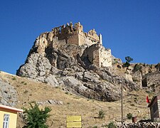
Kahta castle


References[]
| Wikivoyage has a travel guide for Kahta. |
- ^ "Area of regions (including lakes), km²". Regional Statistics Database. Turkish Statistical Institute. 2002. Retrieved 2013-03-05.
- ^ "Population of province/district centers and towns/villages by districts - 2012". Address Based Population Registration System (ABPRS) Database. Turkish Statistical Institute. Retrieved 2013-02-27.
- ^ "Adıyaman - İbrahim Sediyani". Haksöz Haber (in Turkish). 28 August 2010. Retrieved 17 December 2019.
- ^ Tahir Sezen, Osmanlı Yer Adları (Alfabetik Sırayla), T.C. Başbakanlık Devlet Arşivleri Genel Müdürlüğü, Yayın Nu 21, Ankara, p. 264.
- ^ Kaiser, Hilmar (2019). "Financing the Ruling Party and Its Militants in Wartime: The Armenian Genocide and the Kemah Massacres of 1915". Études arméniennes contemporaines. 12 (12): 7–31. doi:10.4000/eac.1942.
- ^ Aşiretler raporu (in Turkish). Kaynak Yayınları. 2014. p. 24. ISBN 978-975-343-220-7.
- ^ "Paleolithic art unveiled after dam water ebbs in Turkey's east". Hürriyet Daily News. 12 October 2018.
| Wikimedia Commons has media related to Kâhta. |

|
This geographical article about a location in Adıyaman Province, Turkey is a stub. You can help Wikipedia by . |
Categories:
- Kâhta
- Populated places in Adıyaman Province
- Districts of Adıyaman Province
- Kurdish settlements in Adıyaman Province
- Adıyaman Province geography stubs