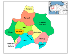
Kütahya
Kütahya | |
|---|---|
 Kütahya view | |
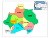
 Location of Kütahya within Turkey. | |
 Kütahya Location of Kütahya within Turkey. | |
| Coordinates: 39°25′N 29°59′E / 39.417°N 29.983°ECoordinates: 39°25′N 29°59′E / 39.417°N 29.983°E | |
| Country | |
| Region | Aegean |
| Province | Kütahya |
| Government | |
| Area | |
| • District | 2,484.16 km2 (959.14 sq mi) |
| Elevation | 970 m (3,180 ft) |
| Population (2012)[2] | |
| • Urban | 224,898 |
| • District | 248,054 |
| • District density | 100/km2 (260/sq mi) |
| Time zone | UTC+3 (TRT) |
| Area code(s) | (+90) 274 |
| Website | www.kutahya.bel.tr |


Kütahya (Turkish pronunciation: [cyˈtahja]) is a city in western Turkey with 237,804 inhabitants (2011 estimate), lying on the Porsuk river, at 969 metres above sea level. It is the capital of Kütahya Province, inhabited by some 564,294 people (2011 estimate). The region of Kütahya has large areas of gentle slopes with agricultural land culminating in high mountain ridges to the north and west. The city's Greek name was Kotyaion[pronunciation?], Latinized in Roman times as Cotyaeum[pronunciation?].[3][4]
History[]
Byzantine period[]


The ancient world knew present-day Kütahya as Cotyaeum (Κοτύαιον). It became part of the Roman province of Phrygia Salutaris,[5] but in about 820 became the capital of the new province of Phrygia Salutaris III.
Its bishopric thus changed from being a suffragan of Synnada to a metropolitan see, although with only three suffragan sees according to the Notitia Episcopatuum of Byzantine Emperor Leo VI the Wise (886-912), which is dated to around 901–902.[6] According to the 6th-century historian John Malalas, Cyrus of Panopolis, who had been prefect of the city of Constantinople, was sent there as bishop by Emperor Theodosius II (408-50), after four bishops of the city had been killed. (Two other sources make Cyrus bishop of Smyrna instead.[citation needed]) The bishopric of Cotyaeum was headed in 431 by Domnius, who attended the Council of Ephesus, and in 451 by Marcianus, who was at the Council of Chalcedon. A source cited by Le Quien says that a bishop of Cotyaeum named Eusebius was at the Second Council of Constantinople in 553. Cosmas was at the Third Council of Constantinople in 680–681. Ioannes, a deacon, represented an unnamed bishop of Cotyaeum at the Trullan Council in 692. Bishop Constantinus was at the Second Council of Nicaea in 692, and Bishop Anthimus at the Photian Council of Constantinople (879),[7][8][9] No longer a residential bishopric, Cotyaeum is today listed by the Catholic Church as a titular see.[10]
Turkic and Ottoman rule[]
Under the reign of Byzantine Emperor Justinian I the town was fortified with a double-line of walls and citadel. In 1071 Cotyaeum (or Kotyaion) fell to the Seljuk Turks and later switched hands, falling successively to the Crusaders, Germiyanids, and Timur-Leng (Tamerlane), until finally being incorporated into the Ottoman Empire in 1428.[11] It was initially the center of Anatolia Eyalet till 1827, when the Hüdavendigâr Eyalet was formed. It was later center of the sancak within the borders of the Hüdavendigâr Vilayet in 1867. Troops of Ibrahim Pasha of Egypt briefly occupied it in 1833.
During this time a large number of Christian Armenians settled in Kotyaion/Kütahya, where they came to dominate the tile-making and ceramic-ware production.[12] Kütahya emerged as a renowned center for the Ottoman ceramic industry, producing tiles and faience for mosques, churches, and official buildings in places all over the Middle East.[13] The craft industry of Armenian ceramics in Jerusalem was started by Armenian ceramicist , master of a Kütahya workshop between 1907 and 1915, who was deported from Kütahya in early 1916, during the Armenian genocide, and rediscovered, living as a refugee in Aleppo in 1918, by Sir Mark Sykes, a former patron. Sykes connected him to the new military governor of Jerusalem, Sir Ronald Storrs, and arranged for Ohannessian to travel to Jerusalem to participate in a planned British restoration of the Dome of the Rock.[14]
The fortifications of the city and its environs, which were vital to the security and economic prosperity of the region, were built and rebuilt from antiquity through the Ottoman Period.[15] However, the dates assigned to the many periods of construction and the assessment of the military architecture are open to various interpretations.[16]
At the end of the nineteenth century the population of the kaza of Kütahya numbered 120,333, of which 4,050 were Greeks, 2,533 Armenians, 754 Catholics, and the remainder Turks and other Muslims.[17] Kütahya and the district itself were spared the ravages of the Armenian genocide of 1915, when the Ottoman governor, Faik Ali Bey, went to extreme lengths to protect the Armenian population from being uprooted and sent away on death marches.[17] However, Faik Ali Bey was removed from office in March 1916, and the city's Armenian community suffered in the aftermath under the rule of his successor, Ahmet Mufit Bey. Kütahya was occupied by Greek troops on 17 July 1921 after Battle of Kütahya–Eskişehir during the Turkish War of Independence and captured in ruins[citation needed] after the Battle of Dumlupınar during the Great Offensive on 30 August 1922.[18][19]
Economy[]


The industries of Kütahya have long traditions, going back to ancient times. Kütahya is famous for its kiln products, such as tiles and pottery, which are glazed and multicoloured.[20] Modern industries are sugar refining, tanning, nitrate processing and different products of meerschaum, which is extracted nearby. The local agricultural industry produces cereals, fruits and sugar beet. In addition stock raising is of much importance. Not far from Kütahya there are important mines extracting lignite.
Kütahya is linked by rail and road with Balıkesir 250 km (155 mi) to the west, Konya 450 km (280 mi) to the southeast, Eskişehir 70 km (43 mi) northeast and Ankara 300 km (186 mi) east.
Traditional ceramics[]
A small ewer, now in the British Museum, gave its name to a category of similar blue and white fritware pottery known as 'Abraham of Kütahya ware'. It has an inscription in Armenian script under the glaze on its base stating that it commemorated Abraham of Kütahya with a date of 1510.[21] In 1957 Arthur Lane published an influential article in which he reviewed the history of pottery production in the region and proposed that 'Abraham of Kütahya' ware was produced from 1490 until around 1525, 'Damascus' and 'Golden Horn' ware were produced from 1525 until 1555 and 'Rhodian' ware from around 1555 until the demise of the İznik pottery industry at the beginning of the 18th century. This chronology has been generally accepted.[22]
Climate[]
Kütahya has a warm-summer Mediterranean climate (Köppen climate classification: Csb), or a temperate continental climate (Trewartha climate classification: Dc), with chilly, wet, often snowy winters and warm, dry summers. Rainfall occurs mostly during the winter and spring, but can be observed throughout the year.
| hideClimate data for Kütahya (1991–2020, extremes 1929–2020) | |||||||||||||
|---|---|---|---|---|---|---|---|---|---|---|---|---|---|
| Month | Jan | Feb | Mar | Apr | May | Jun | Jul | Aug | Sep | Oct | Nov | Dec | Year |
| Record high °C (°F) | 17.1 (62.8) |
24.2 (75.6) |
27.0 (80.6) |
30.2 (86.4) |
34.3 (93.7) |
36.2 (97.2) |
39.5 (103.1) |
38.8 (101.8) |
38.4 (101.1) |
31.9 (89.4) |
25.4 (77.7) |
21.7 (71.1) |
39.5 (103.1) |
| Average high °C (°F) | 5.1 (41.2) |
7.7 (45.9) |
11.8 (53.2) |
16.8 (62.2) |
21.9 (71.4) |
25.9 (78.6) |
29.2 (84.6) |
29.4 (84.9) |
25.4 (77.7) |
19.7 (67.5) |
13.2 (55.8) |
6.8 (44.2) |
17.7 (63.9) |
| Daily mean °C (°F) | 0.6 (33.1) |
2.3 (36.1) |
5.8 (42.4) |
10.2 (50.4) |
15.0 (59.0) |
18.8 (65.8) |
21.6 (70.9) |
21.6 (70.9) |
17.4 (63.3) |
12.4 (54.3) |
6.6 (43.9) |
2.4 (36.3) |
11.2 (52.2) |
| Average low °C (°F) | −2.7 (27.1) |
−1.8 (28.8) |
0.8 (33.4) |
4.4 (39.9) |
8.6 (47.5) |
12.0 (53.6) |
14.5 (58.1) |
14.7 (58.5) |
10.4 (50.7) |
6.7 (44.1) |
2.0 (35.6) |
−0.7 (30.7) |
5.7 (42.3) |
| Record low °C (°F) | −26.3 (−15.3) |
−27.4 (−17.3) |
−16.6 (2.1) |
−7.8 (18.0) |
−2.8 (27.0) |
0.5 (32.9) |
2.6 (36.7) |
−0.2 (31.6) |
−3.9 (25.0) |
−6.9 (19.6) |
−11.0 (12.2) |
−28.1 (−18.6) |
−28.1 (−18.6) |
| Average precipitation mm (inches) | 64.2 (2.53) |
53.3 (2.10) |
53.0 (2.09) |
52.8 (2.08) |
57.5 (2.26) |
43.6 (1.72) |
19.2 (0.76) |
24.6 (0.97) |
26.7 (1.05) |
43.2 (1.70) |
45.3 (1.78) |
67.2 (2.65) |
550.6 (21.68) |
| Average precipitation days | 12.47 | 11.30 | 11.67 | 12.30 | 12.73 | 8.90 | 3.83 | 4.57 | 6.00 | 8.80 | 8.70 | 11.80 | 113.1 |
| Mean monthly sunshine hours | 68.2 | 98.9 | 145.7 | 189.0 | 229.4 | 273.0 | 319.3 | 297.6 | 225.0 | 161.2 | 114.0 | 65.1 | 2,186.4 |
| Mean daily sunshine hours | 2.2 | 3.5 | 4.7 | 6.3 | 7.4 | 9.1 | 10.3 | 9.6 | 7.5 | 5.2 | 3.8 | 2.1 | 6.0 |
| Source: Turkish State Meteorological Service[23] | |||||||||||||
Kütahya is forecast to be the city most affected by global warming in Turkey.[24]
Culture[]
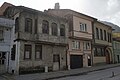
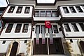
Kütahya's old neighbourhoods are dominated by traditional Ottoman houses made of wood and stucco, some of the best examples being found along Germiyan Caddesi. It has many historical mosques such as Ulu Camii, Cinili Camii, Balikli Camii and Donenler Camii. The Şengül Hamamı is a famous Turkish bath located in the city
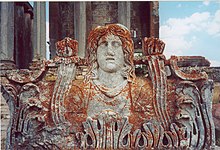
The town preserves some ancient ruins, a Byzantine castle and church. During late centuries Kütahya has been renowned for its Turkish earthenware, of which fine specimens may be seen at the national capital. The Kütahya Museum has a fine collection of arts and cultural artifacts from the area, the house where Hungarian statesman Lajos Kossuth lived in exile between 1850 and 1851 is preserved as a museum.[1]

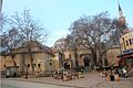
Kütahya Old town
Kütahya Old houses in Sultanbağı region

Kütahya Old houses in Sultanbağı region

Kütahya Old houses in Sultanbağı region
Kütahya City Museum
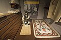
Kütahya City Museum Felt maker

Kütahya City Museum Saddle maker
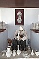
Kütahya City Museum Biscuit maker
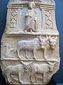
Kütahya archaeological museum Stele
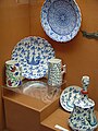
Kutahya Ceramics museum
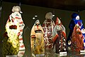
Kutahya Ceramics museum Figurines

Kütahya Lajos Kossuth house

Kütahya Lajos Kossuth house

Kütahya Ulu Cami

Kutahya Dönenler Mosque

Kütahya Dönenler Mosque
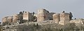
Kütahya Castle Hill


Education[]

The Main Campus and the Germiyan Campus of the Kütahya Dumlupınar University are located in the city.
Transport[]

The main bus station has bus links to most major Turkish cities. Zafer Airport is active. Kastamonu is also the main railroad endpoint for the Aegean region.
International relations[]
Twin towns — Sister cities[]
Kütahya is twinned with:
Notable people[]
- Abdullah Aymaz, writer and journalist
- , politician
- Alexander of Cotiaeum, ancient Greek grammarian
- , politician
- Aydilge Sarp, singer.
- Âsım Gündüz, military officer in the Ottoman and Turkish armies
- Ayla Dikmen, singer
- , ceramist
- Danla Bilic , Youtuber
- , Armenian ceramist
- Evliya Çelebi, Turkish globe traveler and author.
- Halil Akkaş, middle-distance runner
- Hande Baladın, volleyball player
- Kadri Paşa, Ottoman Grand Vizier (1880)
- Komitas Vardapet, Armenian composer, musicologist
- Mustafa Kalemli, politician
- , businessman
- , politician who was state minister
- , military commander
- Özge Kırdar, volleyball player
- , video game streamer known as pqueen
- , politician and governor
- , politician and governor
- Veli Kızılkaya, football player
See also[]
Gallery[]

Rüstem Pasha Madrasa

Tiled Mosque

Mother Sultan

Kütahya Castle

Government House
Grand Mosque


References[]
- ^ "Area of regions (including lakes), km²". Regional Statistics Database. Turkish Statistical Institute. 2002. Retrieved 2013-03-05.
- ^ "Population of province/district centers and towns/villages by districts - 2012". Address Based Population Registration System (ABPRS) Database. Turkish Statistical Institute. Retrieved 2013-02-27.
- ^ http://www.newadvent.org/cathen/04422a.htm Catholic Encyclopaedia: Cotiaeum.
- ^ "Kütahya Turkey, britannica.com".
- ^ Heinrich Gelzer, Ungedruckte und ungenügend veröffentlichte Texte der Notitiae episcopatuum, in: Abhandlungen der philosophisch-historische classe der bayerische Akademie der Wissenschaften, 1901, p. 540, nº 338.
- ^ Gelzer, op. cit., p. 559, nnº 650-653.
- ^ Le Quien, Michel (1740). Oriens Christianus, in quatuor Patriarchatus digestus: quo exhibentur ecclesiæ, patriarchæ, cæterique præsules totius Orientis. Tomus primus: tres magnas complectens diœceses Ponti, Asiæ & Thraciæ, Patriarchatui Constantinopolitano subjectas (in Latin). Paris: Ex Typographia Regia. coll. 851-852. OCLC 955922585.
- ^ Raymond Janin, v. Cotyaeum, in Dictionnaire d'Histoire et de Géographie ecclésiastiques, vol. 13, Paris 1956, coll. 938-940
- ^ Pius Bonifacius Gams, Series episcoporum Ecclesiae Catholicae, Leipzig 1931, p. 447
- ^ Annuario Pontificio 2013 (Libreria Editrice Vaticana 2013 ISBN 978-88-209-9070-1), p. 875.
- ^ "History of Kutahya".
- ^ Hovannisian, Richard G. and Armen Manuk-Khaloyan, "The Armenian Communities of Asia Minor," in Armenian Communities of Asia Minor, ed. Richard G. Hovannisian. UCLA Armenian History and Culture Series: Historic Armenian Cities and Provinces, 13. Costa Mesa, CA: Mazda Publishers, 2014, pp. 32-34.
- ^ See Dickran Kouymjian, "The Role of Armenian Potters of Kutahia in the Ottoman Ceramic Industry," in Armenian Communities of Asia Minor, pp. 107-30.
- ^ Moughalian, Sato. Feast of Ashes: The Life and Art of David Ohannessian. Stanford, CA: Redwood Press, 2019.
- ^ Foss, Clive (1985). Survey of the Medieval Castles of Anatolia: Kütahya. Oxford, U.K.: BAR. pp. 12ff.
- ^ Edwards, Robert W., “Medieval Castles of Anatolia: Kütahya,” Speculum 62 (1987): pp. 675-680.
- ^ Jump up to: a b Hovannisian and Manuk-Khaloyan, "The Armenian Communities of Asia Minor," p. 34.
- ^ "Gamblers on Turkish Brink" (PDF).
- ^ "Kütahya".
- ^ Henry Glassie, Turkish Traditional Art Today Bloomington: Indiana University Press, 1993, pp. 435 ff.
- ^ 'Abraham of Kütahya' ewer, British Museum Accession Code: G.1
- ^ Nurhan Atasoy and Julian Raby (authors), Yanni Petsopoulos (editor) (1989). Iznik: The Pottery of Ottoman Turkey. London: Alexandria Press. ISBN 978-1-85669-054-6.CS1 maint: extra text: authors list (link)
- ^ "Resmi İstatistikler: İllerimize Ait Mevism Normalleri (1991–2020)" (in Turkish). Turkish State Meteorological Service. Retrieved 1 May 2021.
- ^ "Evaluation of the Global Warming Impacts Using a Hybrid Method Based on Fuzzy Techniques: A Case Study in Turkey". Cite journal requires
|journal=(help)
Source and external links[]
| Wikimedia Commons has media related to Kütahya. |
| Wikivoyage has a travel guide for Kütahya. |
- The Government of Kütahya
- Province Culture And Tourism Directorate
- City of Tiles
- Pictures from Kütahya
- Kütahya weather forecast information
- Photos of ancient Roman city of Aizanoi in Kütahya
- Photos from another source of ancient Roman city of Aizanoi in Kütahya province
- A website about a nitrate processing factory in Kütahya
- A website about the sugar refinery facility in Kütahya
- Official website of Kütahya Ceramic Company
- Kütahya Photo Forum
![]() This article incorporates text from a publication now in the public domain: Herbermann, Charles, ed. (1913). Catholic Encyclopedia. New York: Robert Appleton Company. Missing or empty
This article incorporates text from a publication now in the public domain: Herbermann, Charles, ed. (1913). Catholic Encyclopedia. New York: Robert Appleton Company. Missing or empty |title= (help)
| show Kütahya in Kütahya Province of Turkey |
|---|
| Authority control |
|---|
- Kütahya
- Districts of Kütahya Province