LaGrange County, Indiana
LaGrange County | |
|---|---|
U.S. county | |
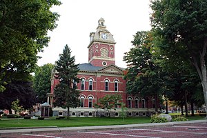 LaGrange County courthouse in LaGrange, Indiana. Built in the 1870s and now on the National Register of Historic Places | |
 Location within the U.S. state of Indiana | |
 Indiana's location within the U.S. | |
| Coordinates: 41°38′30″N 85°25′00″W / 41.641666666667°N 85.416666666667°W | |
| Country | |
| State | |
| Founded | 1832 |
| Named for | Château de la Grange-Bléneau |
| Seat | LaGrange |
| Largest city | LaGrange |
| Area | |
| • Total | 386.70 sq mi (1,001.5 km2) |
| • Land | 379.62 sq mi (983.2 km2) |
| • Water | 7.08 sq mi (18.3 km2) 1.83%% |
| Population (2020) | |
| • Total | 40,446 |
| • Density | 106.5/sq mi (41.1/km2) |
| Time zone | UTC−5 (Eastern) |
| • Summer (DST) | UTC−4 (EDT) |
| Congressional district | 3rd |
| Website | www |
| Indiana county number 44 | |

LaGrange County is a county located in the U.S. state of Indiana. As of 2020, the population was 40,446.[1] The county seat is LaGrange, Indiana.[2]
The county is located in the Northern Indiana region known as Michiana and is about 55 miles (89 km) east of South Bend, 105 miles (169 km) west of Toledo, Ohio, and 175 miles (282 km) northeast of Indianapolis. The area is well known for its large Amish population.[3] For that reason, the county teams up with neighboring Elkhart County to promote tourism by referring to the area as Northern Indiana Amish Country.[4]
Over a third of the population of LaGrange County is Amish, and it is home to the third-largest Amish community in the United States, which belongs to the Elkhart-LaGrange Amish affiliation.
History[]
The first settlement of LaGrange County was founded about a half mile west of Lima in 1828. Over the next four years, settlers flocked to parts of Lima, Springfield, and Van Buren Townships. Finally in 1832, LaGrange County was carved out of neighboring Elkhart County and established with Lima as the county seat.[5] The town of LaGrange was platted in 1836 and settled in 1842 as the new county seat, closer to the center of the county.[6] Lima's name was changed to Howe in 1909.[5] LaGrange was laid out and platted in 1836.[7]
LaGrange County's initial settlers were Yankee immigrants, that is to say, they were from New England. They were descended from the English Puritans who settled that region in the colonial era. They were part of a wave of New England settlers moving west into what was then the Northwest Territory after the completion of the Erie Canal. The original settlers in LaGrange County specifically hailed from the Massachusetts counties of Worcester County, Suffolk County and Berkshire County; the Connecticut counties of Hartford County and Windham County as well as the Connecticut towns of Sherman, Lebanon and Fairfield; and from the Vermont towns of Burlington, Brookfield, Huntington and Grand Isle. They were mainly members of the Congregational Church, but as a result of the Second Great Awakening, many became Baptists and many also converted to Pentecostalism and Methodism. When they arrived in LaGrange County, there was nothing but a virgin forest and wild prairie. The New England settlers cleared roads, built farms, constructed churches, erected government buildings, and established post routes. As a result of this migration, LaGrange County was culturally continuous with early New England culture for many years.[8]
In 1837, the government removed Chief Shipshewana and the Potawatomi Tribe from the county's northwest corner. Several years later, the Chief was allowed to return and died in Newbury Township in 1841.[5] A town named Georgetown had been platted in 1837 but was abandoned because of lack of development. In 1844, the first Amish came from Pennsylvania to settle around the old town. The village continued to grow, and the town of Shipshewana was platted nearby in 1899 and incorporated in 1916 in Newbury Township.[5]
LaGrange County was named after the Château de la Grange-Bléneau, home of Revolutionary War hero, the Marquis de la Fayette, outside of Paris, France.[9]
Geography[]
According to the 2010 census, the county has a total area of 386.70 square miles (1,001.5 km2), of which 379.62 square miles (983.2 km2) (or 98.17%) is land and 7.08 square miles (18.3 km2) (or 1.83%) is water.[10]
The county is mostly made up of rural farmland but also some rolling hills and several lakes.
Adjacent counties[]
- St. Joseph County, Michigan (northwest)
- Branch County, Michigan (northeast)
- Steuben County (east)
- Noble County (south)
- Elkhart County (west)
Transportation[]
Major highways[]


 I-80 / I-90 / Indiana Toll Road
Climate and weather[]
| LaGrange, Indiana | ||||||||||||||||||||||||||||||||||||||||||||||||||||||||||||
|---|---|---|---|---|---|---|---|---|---|---|---|---|---|---|---|---|---|---|---|---|---|---|---|---|---|---|---|---|---|---|---|---|---|---|---|---|---|---|---|---|---|---|---|---|---|---|---|---|---|---|---|---|---|---|---|---|---|---|---|---|
| Climate chart (explanation) | ||||||||||||||||||||||||||||||||||||||||||||||||||||||||||||
| ||||||||||||||||||||||||||||||||||||||||||||||||||||||||||||
| ||||||||||||||||||||||||||||||||||||||||||||||||||||||||||||
In recent years, average temperatures in LaGrange have ranged from a low of 14 °F (−10 °C) in January to a high of 82 °F (28 °C) in July, although a record low of −28 °F (−33 °C) was recorded in December 2000 and a record high of 104 °F (40 °C) was recorded in June 1988. Average monthly precipitation ranged from 1.76 inches (45 mm) in February to 4.17 inches (106 mm) in June.[11]
Demographics[]
| Historical population | |||
|---|---|---|---|
| Census | Pop. | %± | |
| 1840 | 3,664 | — | |
| 1850 | 8,387 | 128.9% | |
| 1860 | 11,366 | 35.5% | |
| 1870 | 14,148 | 24.5% | |
| 1880 | 15,630 | 10.5% | |
| 1890 | 15,615 | −0.1% | |
| 1900 | 15,284 | −2.1% | |
| 1910 | 15,148 | −0.9% | |
| 1920 | 14,009 | −7.5% | |
| 1930 | 13,780 | −1.6% | |
| 1940 | 14,352 | 4.2% | |
| 1950 | 15,347 | 6.9% | |
| 1960 | 17,380 | 13.2% | |
| 1970 | 20,890 | 20.2% | |
| 1980 | 25,550 | 22.3% | |
| 1990 | 29,477 | 15.4% | |
| 2000 | 34,909 | 18.4% | |
| 2010 | 37,128 | 6.4% | |
| 2020 | 40,446 | 8.9% | |
| U.S. Decennial Census[12] 1790-1960[13] 1900-1990[14] 1990-2000[15] 2010-2013[16] 2020[1] | |||
As of the 2010 United States Census, there were 37,128 people, 11,598 households, and 9,106 families residing in the county.[17] The population density was 97.8 inhabitants per square mile (37.8/km2). There were 14,094 housing units at an average density of 37.1 per square mile (14.3/km2).[10] The racial makeup of the county was 96.6% white, 0.3% black or African American, 0.3% Asian, 0.2% American Indian, 1.7% from other races, and 0.8% from two or more races. Those of Hispanic or Latino origin made up 3.5% of the population.[17] In terms of ancestry, 36.1% were German, 13.3% were American, 6.4% were Irish, and 6.4% were English.[18]
Of the 11,598 households, 40.2% had children under the age of 18 living with them, 67.6% were married couples living together, 7.1% had a female householder with no husband present, 21.5% were non-families, and 18.4% of all households were made up of individuals. The average household size was 3.17, and the average family size was 3.66. The median age was 30.4 years.[17]
The median income for a household in the county was $47,697 and the median income for a family was $53,793. Males had a median income of $40,960 versus $29,193 for females. The per capita income for the county was $18,388. About 12.1% of families and 16.0% of the population were below the poverty line, including 23.5% of those under age 18 and 16.6% of those age 65 or over.[19]
Amish community[]

Approximately 37% of the population of LaGrange County is Amish, as the county is home to the third-largest Amish community in the United States and belongs to the Elkhart-LaGrange Amish affiliation. This is reflected in the linguistic situation in the county: 28.45% of the population report speaking German, Pennsylvania German, or Dutch at home.[20] 68.5% of the total population and 61.29% of the children in 5-17 age group used English as their home language, according to 2000 Census. The Amish languages (German, Pennsylfaansch, and Dutch) were used by 28.47% of the total population and 35.77% of them.[21]
As of 2020 census, Terry Martin, president of the LaGrange County Commissioners, said that "the Amish-English ratio is about 50-50", also adding that the nearly 9% growth, or 3,318 people [between 2010 and 2020 censuses], was mainly due to the increasing Amish population.[1]
Communities[]
Towns[]
- LaGrange
- Shipshewana
- Topeka
- Wolcottville (partially in Noble County)
Townships[]
Census-designated place[]
Other unincorporated communities[]
Economy[]
The economy is based mainly on agriculture and small shops, but tourism also plays a big role, especially in Shipshewana.
Government[]
The county is led by a board of three elected commissioners that serve as the county government's executive branch. The county council comprises 7 elected members – four from each council district and 3 at large. Also, one assessor serves the entire county as opposed to one for every township.
The current county commissioners are:[22]
- North District: Terry Martin
- Middle District: Kevin Myers
- South District: Larry Miller
The current county council members are:[23]
- Charles F. Ashcraft D - District 1
- George Bachman R- District 2
- Harold Gingerich R - District 3
- Peter Cook R - District 4
- Ben Taylor R - at large
- Steve McKowen R - at large
- Mike Strawser R - at large
LaGrange County is part of Indiana's 3rd congressional district; Indiana Senate district 13;[24] and Indiana House of Representatives districts 18 and 52.[25]
LaGrange County has consistently been a Republican Party stronghold in presidential elections. In only three elections since 1888 has a Republican candidate failed to win the county, most recently in 1964.
Education[]

The county has three public school districts.
Public schools[]
The Lakeland Community Schools serve the central part of the county. The system includes Lakeland Primary: Grades (k-2), Lakeland Intermediate: grades (3-6), and Lakeland Jr/Sr High: grades (7-12).
The Prairie Heights School Corporation serves the east side of the county and parts of Steuben County. The mascot of Prairie Heights School is a black panther.
The Westview School Corporation serves the west portion of the county. This system consists of four elementary schools (Meadowview, Shipshewana-Scott, Topeka, and Westview) and one junior-senior high school named Westview.
Private schools[]
Several Amish schools are located across the county.
Public library[]
LaGrange County is served by the La Grange County Public Library, with branches in LaGrange, Shipshewana, and Topeka.[27]
See also[]
- List of counties in Indiana
- List of counties in Michigan
- Michiana
- National Register of Historic Places listings in LaGrange County, Indiana
- The News Sun, the daily newspaper covering LaGrange County
References[]
- ^ Jump up to: a b c "CENSUS 2020: LaGrange County leads local area in population growth". news.yahoo.com. Retrieved 2021-09-01.
- ^ "Find a County". National Association of Counties. Retrieved 2011-06-07.
- ^ "Archived copy". Archived from the original on 2012-10-22. Retrieved 2008-08-01.CS1 maint: archived copy as title (link)
- ^ Welcome to Northern Indiana Amish Country
- ^ Jump up to: a b c d http://www.rootsweb.ancestry.com/~inlagran/lghist.html
- ^ "Archived copy". Archived from the original on 2006-10-18. Retrieved 2008-08-01.CS1 maint: archived copy as title (link)
- ^ Counties of LaGrange and Noble, Indiana: Historical and Biographical. F.A. Battey & Company. 1882. p. 111.
- ^ The expansion of New England: the spread of New England settlement and institutions to the Mississippi River, 1620-1865 by Lois Kimball Matthews p. 201
- ^ De Witt Clinton Goodrich & Charles Richard Tuttle (1875). An Illustrated History of the State of Indiana. Indiana: R. S. Peale & co. pp. 564.
- ^ Jump up to: a b "Population, Housing Units, Area, and Density: 2010 - County". United States Census Bureau. Archived from the original on 2020-02-12. Retrieved 2015-07-10.
- ^ Jump up to: a b "Monthly Averages for LaGrange, Indiana". The Weather Channel. Retrieved 2011-01-27.
- ^ "U.S. Decennial Census". United States Census Bureau. Retrieved July 10, 2014.
- ^ "Historical Census Browser". University of Virginia Library. Retrieved July 10, 2014.
- ^ "Population of Counties by Decennial Census: 1900 to 1990". United States Census Bureau. Retrieved July 10, 2014.
- ^ "Census 2000 PHC-T-4. Ranking Tables for Counties: 1990 and 2000" (PDF). United States Census Bureau. Retrieved July 10, 2014.
- ^ "LaGrange County QuickFacts". United States Census Bureau. Archived from the original on 2011-08-06. Retrieved 2011-09-25.
- ^ Jump up to: a b c "DP-1 Profile of General Population and Housing Characteristics: 2010 Demographic Profile Data". United States Census Bureau. Archived from the original on 2020-02-13. Retrieved 2015-07-10.
- ^ "DP02 SELECTED SOCIAL CHARACTERISTICS IN THE UNITED STATES – 2006-2010 American Community Survey 5-Year Estimates". United States Census Bureau. Archived from the original on 2020-02-14. Retrieved 2015-07-10.
- ^ "DP03 SELECTED ECONOMIC CHARACTERISTICS – 2006-2010 American Community Survey 5-Year Estimates". United States Census Bureau. Archived from the original on 2020-02-14. Retrieved 2015-07-10.
- ^ [1]
- ^ [2]
- ^ "Archived copy". Archived from the original on 2008-06-08. Retrieved 2008-08-01.CS1 maint: archived copy as title (link)
- ^ "LaGrange County Council Contact Information". lagrangecounty.org. Retrieved 2018-05-17.
- ^ "Indiana Senate Districts". State of Indiana. Retrieved 2011-07-14.
- ^ "Indiana House Districts". State of Indiana. Retrieved 2011-07-14.
- ^ Leip, David. "Dave Leip's Atlas of U.S. Presidential Elections". uselectionatlas.org. Retrieved 2021-02-22.
- ^ "Homepage". La Grange County Public Library. Retrieved 8 March 2018.
External links[]
| show Places adjacent to LaGrange County, Indiana |
|---|
| show Municipalities and communities of LaGrange County, Indiana, United States |
|---|

Coordinates: 41°38′30″N 85°25′00″W / 41.64167°N 85.41667°W
| show Authority control |
|---|
- Indiana counties
- LaGrange County, Indiana
- 1832 establishments in Indiana
- Populated places established in 1832
- Amish in Indiana