La Baume-Cornillane
La Baume-Cornillane | |
|---|---|
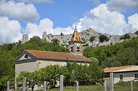 The church of La Baume-Cornillane | |
show Location of La Baume-Cornillane | |
 La Baume-Cornillane | |
| Coordinates: 44°49′28″N 5°02′28″E / 44.8244°N 5.0411°ECoordinates: 44°49′28″N 5°02′28″E / 44.8244°N 5.0411°E | |
| Country | France |
| Region | Auvergne-Rhône-Alpes |
| Department | Drôme |
| Arrondissement | Valence |
| Canton | Crest |
| Intercommunality | CA Valence Romans Agglo |
| Government | |
| • Mayor (2014–2020) | Jean Meurillon |
| Area 1 | 14.42 km2 (5.57 sq mi) |
| Population (Jan. 2018)[1] | 447 |
| • Density | 31/km2 (80/sq mi) |
| Time zone | UTC+01:00 (CET) |
| • Summer (DST) | UTC+02:00 (CEST) |
| INSEE/Postal code | 26032 /26120 |
| Elevation | 230–1,009 m (755–3,310 ft) (avg. 308 m or 1,010 ft) |
| 1 French Land Register data, which excludes lakes, ponds, glaciers > 1 km2 (0.386 sq mi or 247 acres) and river estuaries. | |


La Baume-Cornillane is a commune in the Drôme department in southeastern France.
Its inhabitants are called Balmois.
Geography[]
La Baume-Cornillane is located 15 km from Crest and 18 km from Valence. The territory of the municipality consists of three parts: the plain, the foothills of the Vercors Massif and the mountain.
Population[]
| Year | Pop. | ±% |
|---|---|---|
| 1911 | 386 | — |
| 1962 | 240 | −37.8% |
| 1968 | 203 | −15.4% |
| 1975 | 186 | −8.4% |
| 1982 | 245 | +31.7% |
| 1990 | 321 | +31.0% |
| 1999 | 396 | +23.4% |
| 2008 | 445 | +12.4% |
See also[]
References[]
- ^ "Populations légales 2018". INSEE. 28 December 2020.
| Wikimedia Commons has media related to La Baume-Cornillane. |
This Drôme geographical article is a stub. You can help Wikipedia by . |
Categories:
- Communes of Drôme
- Drôme geography stubs