La Chapelle-des-Pots
La Chapelle-des-Pots | |
|---|---|
 A general view of La Chapelle-des-Pots | |
 Coat of arms | |
show Location of La Chapelle-des-Pots | |
 La Chapelle-des-Pots | |
| Coordinates: 45°45′38″N 0°32′22″W / 45.7606°N 0.5394°WCoordinates: 45°45′38″N 0°32′22″W / 45.7606°N 0.5394°W | |
| Country | France |
| Region | Nouvelle-Aquitaine |
| Department | Charente-Maritime |
| Arrondissement | Saintes |
| Canton | Chaniers |
| Government | |
| • Mayor (2008–2014) | Jean-Claude Couprie |
| Area 1 | 10.27 km2 (3.97 sq mi) |
| Population (Jan. 2018)[1] | 1,004 |
| • Density | 98/km2 (250/sq mi) |
| Time zone | UTC+01:00 (CET) |
| • Summer (DST) | UTC+02:00 (CEST) |
| INSEE/Postal code | 17089 /17100 |
| Elevation | 19–88 m (62–289 ft) |
| 1 French Land Register data, which excludes lakes, ponds, glaciers > 1 km2 (0.386 sq mi or 247 acres) and river estuaries. | |


La Chapelle-des-Pots is a commune in the center-east of the Charente-Maritime department in southwestern France, in the former province of Saintonge.
History[]
La Chapelle-des-Pots is a village where potters make ceramics for more than eight centuries. Many woods, brooks and local clay allowed the creation of ceramics. Bernard Palissy even worked with local potters.
Population[]
|
|
Places and monuments[]
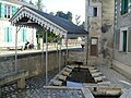
In the center of the town: a fountain covered with a dome made of cut stone and thrown into a wash-house, the church of Saint-Front (1786), whose foundations use stones from the old potters' chapel (Municipal Bulletin). A ceramic kiln built in 2006 of the chain type located near the town hall, an old ceramic kiln, call Varoqeau kiln, inscribed in historical monuments.
A school group inaugurated in 1955.
The municipality had an interesting regional museum: the Saintongean Ceramics Museum, where collections of local pottery from XIIIe to XXe. This museum, founded under the mandate of Raymond Viollier was closed by the current municipality.
Exterior of the borough: old seigniory, several small stone washhouses, numerous hiking trails VTT and pedestrian.
Environmental Heritage[]
The which runs from Royan to Grasse crosses the town and runs along the fountain of the center of the town.
See also[]
- Communes of the Charente-Maritime department
- Cognac, France
Gallery[]

La Chapelle-des-Pots Neoclassical church


References[]
- ^ "Populations légales 2018". INSEE. 28 December 2020.
| Wikimedia Commons has media related to La Chapelle-des-Pots. |
This Charente-Maritime geographical article is a stub. You can help Wikipedia by . |
- Communes of Charente-Maritime
- Charente-Maritime geography stubs