Lichères
Lichères | |
|---|---|
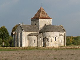 The church in Lichères | |
show Location of Lichères | |
 Lichères | |
| Coordinates: 45°53′52″N 0°13′26″E / 45.8978°N 0.2239°ECoordinates: 45°53′52″N 0°13′26″E / 45.8978°N 0.2239°E | |
| Country | France |
| Region | Nouvelle-Aquitaine |
| Department | Charente |
| Arrondissement | Confolens |
| Canton | Boixe-et-Manslois |
| Government | |
| • Mayor (2020–2026) | Jean-Jacques Crine[1] |
| Area 1 | 4.94 km2 (1.91 sq mi) |
| Population (Jan. 2018)[2] | 87 |
| • Density | 18/km2 (46/sq mi) |
| Time zone | UTC+01:00 (CET) |
| • Summer (DST) | UTC+02:00 (CEST) |
| INSEE/Postal code | 16184 /16460 |
| Elevation | 60–117 m (197–384 ft) (avg. 93 m or 305 ft) |
| 1 French Land Register data, which excludes lakes, ponds, glaciers > 1 km2 (0.386 sq mi or 247 acres) and river estuaries. | |


Lichères is a commune in the Charente department in southwestern France. It straddles the river Charente comprising the villages of Lichéres, La Salle and Puychenin. The village of Lichéres is home to a 12th-century catholic church dedicated to Saint Denis. Although there is a conventional road bridge across the river Charente near La Salle there is also a very small ferry called a Barque. The Barque is guided by a steel wire with which users propel the boat.
Population[]
|
|
Gallery[]

Barque of Lichères
See also[]
References[]
- ^ "Répertoire national des élus: les maires". data.gouv.fr, Plateforme ouverte des données publiques françaises (in French). 2 December 2020.
- ^ "Populations légales 2018". INSEE. 28 December 2020.
| Wikimedia Commons has media related to Lichères. |
This Charente geographical article is a stub. You can help Wikipedia by . |
Categories:
- Communes of Charente
- Charente geography stubs