Manduel
Manduel | |
|---|---|
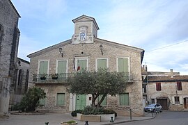 The town hall in Manduel | |
 Coat of arms | |
show Location of Manduel | |
 Manduel | |
| Coordinates: 43°49′10″N 4°28′27″E / 43.8194°N 4.4742°ECoordinates: 43°49′10″N 4°28′27″E / 43.8194°N 4.4742°E | |
| Country | France |
| Region | Occitanie |
| Department | Gard |
| Arrondissement | Nîmes |
| Canton | Marguerittes |
| Intercommunality | CA Nîmes Métropole |
| Government | |
| • Mayor (2008–2014) | Marie-Louise Sabatier |
| Area 1 | 26.46 km2 (10.22 sq mi) |
| Population (Jan. 2018)[1] | 6,871 |
| • Density | 260/km2 (670/sq mi) |
| Time zone | UTC+01:00 (CET) |
| • Summer (DST) | UTC+02:00 (CEST) |
| INSEE/Postal code | 30155 /30129 |
| Elevation | 50–77 m (164–253 ft) (avg. 62 m or 203 ft) |
| Website | www.manduel.fr |
| 1 French Land Register data, which excludes lakes, ponds, glaciers > 1 km2 (0.386 sq mi or 247 acres) and river estuaries. | |


Manduel (Occitan: Manduelh) is a commune in the Gard department in southern France.
Population[]
| Year | Pop. | ±% |
|---|---|---|
| 1938 | 1,953 | — |
| 1942 | 986 | −49.5% |
| 1946 | 1,328 | +34.7% |
| 1956 | 1,453 | +9.4% |
| 1968 | 1,649 | +13.5% |
| 1975 | 2,389 | +44.9% |
| 1982 | 3,554 | +48.8% |
| 1990 | 5,579 | +57.0% |
| 1999 | 5,748 | +3.0% |
| 2008 | 5,721 | −0.5% |
| 2012 | 5,773 | +0.9% |
See also[]
- Communes of the Gard department
- Costières de Nîmes AOC
References[]
- ^ "Populations légales 2018". INSEE. 28 December 2020.
External links[]
| Wikimedia Commons has media related to Manduel. |
| show Communes of the Gard department |
|---|
| show Authority control |
|---|
This Gard geographical article is a stub. You can help Wikipedia by . |
Categories:
- Communes of Gard
- Gard geography stubs