Merino, Colorado
Town of Merino, Colorado | |
|---|---|
Statutory Town | |
 Platte Street in Merino. | |
 Location of Merino in Logan County, Colorado. | |
| Coordinates: 40°29′4″N 103°21′13″W / 40.48444°N 103.35361°WCoordinates: 40°29′4″N 103°21′13″W / 40.48444°N 103.35361°W | |
| Country | |
| State | |
| County[1] | Logan |
| Incorporated (town) | January 4, 1917[2] |
| Government | |
| • Type | Statutory Town[1] |
| Area | |
| • Total | 0.15 sq mi (0.39 km2) |
| • Land | 0.15 sq mi (0.39 km2) |
| • Water | 0.00 sq mi (0.00 km2) |
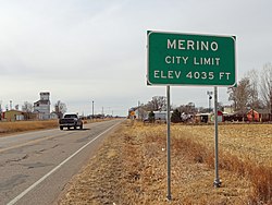
| Elevation | 4,035 ft (1,230 m) |
| Population (2010) | |
| • Total | 284 |
| • Estimate (2019)[5] | 281 |
| • Density | 1,848.68/sq mi (715.60/km2) |
| Time zone | UTC-7 (Mountain (MST)) |
| • Summer (DST) | UTC-6 (MDT) |
| ZIP code[6] | 80741 |
| Area code(s) | 970 |
| FIPS code | 08-50040 |
| GNIS feature ID | 0204720 |

The Town of Merino is a Statutory Town in Logan County, Colorado, United States. The town population was 284 at the 2010 United States Census.
The town was named for the merino sheep which grazed there.[7][8]
Geography[]
Merino is located at 40°29′4″N 103°21′13″W / 40.48444°N 103.35361°W (40.484418, -103.353691).[9]
According to the United States Census Bureau, the town has a total area of 0.2 square miles (0.52 km2), all of it land.
Demographics[]
| Historical population | |||
|---|---|---|---|
| Census | Pop. | %± | |
| 1920 | 263 | — | |
| 1930 | 230 | −12.5% | |
| 1940 | 259 | 12.6% | |
| 1950 | 209 | −19.3% | |
| 1960 | 268 | 28.2% | |
| 1970 | 260 | −3.0% | |
| 1980 | 255 | −1.9% | |
| 1990 | 238 | −6.7% | |
| 2000 | 246 | 3.4% | |
| 2010 | 284 | 15.4% | |
| 2019 (est.) | 281 | [5] | −1.1% |
| U.S. Decennial Census[10] | |||
As of the census[11] of 2000, there were 246 people, 96 households, and 66 families residing in the town. The population density was 1,421.9 people per square mile (558.7/km2). There were 110 housing units at an average density of 635.8 per square mile (249.8/km2). The racial makeup of the town was 93.90% White, 0.81% Native American, 4.07% from other races, and 1.22% from two or more races. Hispanic or Latino of any race were 6.91% of the population.
There were 96 households, out of which 41.7% had children under the age of 18 living with them, 54.2% were married couples living together, 9.4% had a female householder with no husband present, and 31.3% were non-families. 27.1% of all households were made up of individuals, and 14.6% had someone living alone who was 65 years of age or older. The average household size was 2.56 and the average family size was 3.15.
In the town, the population was spread out, with 30.9% under the age of 18, 6.5% from 18 to 24, 25.2% from 25 to 44, 24.4% from 45 to 64, and 13.0% who were 65 years of age or older. The median age was 38 years. For every 100 females, there were 90.7 males. For every 100 females age 18 and over, there were 80.9 males.
The median income for a household in the town was $28,750, and the median income for a family was $31,406. Males had a median income of $26,250 versus $22,000 for females. The per capita income for the town was $14,943. About 7.6% of families and 9.9% of the population were below the poverty line, including 13.3% of those under the age of eighteen and 18.0% of those 65 or over.
Climate[]
According to the Köppen Climate Classification system, Merino has a semi-arid climate, abbreviated "BSk" on climate maps.[12]
Notable People[]
Radio and television host Ralph Edwards was born in Merino.[13] Ralph Edwards Avenue[14] was named in his memory.
See also[]
- Outline of Colorado
- State of Colorado
- Colorado cities and towns
- Colorado municipalities
- Colorado counties
- Colorado metropolitan areas
- Sterling, CO Micropolitan Statistical Area
- Colorado cities and towns
- Ralph Edwards
References[]
- ^ Jump up to: a b "Active Colorado Municipalities". State of Colorado, Department of Local Affairs. Archived from the original on 2009-12-12. Retrieved 2007-09-01.
- ^ "Colorado Municipal Incorporations". State of Colorado, Department of Personnel & Administration, Colorado State Archives. 2004-12-01. Retrieved 2007-09-02.
- ^ "2019 U.S. Gazetteer Files". United States Census Bureau. Retrieved July 1, 2020.
- ^ "US Board on Geographic Names". United States Geological Survey. 2007-10-25. Retrieved 2008-01-31.
- ^ Jump up to: a b "Population and Housing Unit Estimates". United States Census Bureau. May 24, 2020. Retrieved May 27, 2020.
- ^ "ZIP Code Lookup". United States Postal Service. Archived from the original (JavaScript/HTML) on January 1, 2008. Retrieved November 22, 2007.
- ^ Dawson, John Frank. Place names in Colorado: why 700 communities were so named, 150 of Spanish or Indian origin. Denver, CO: The J. Frank Dawson Publishing Co. p. 34.[permanent dead link]
- ^ Exploring Colorado Highways: Trip Trivia. Exploring America's Highway. 2007. p. 109. ISBN 978-0-9777301-0-0.
- ^ "US Gazetteer files: 2010, 2000, and 1990". United States Census Bureau. 2011-02-12. Retrieved 2011-04-23.
- ^ "Census of Population and Housing". Census.gov. Retrieved June 4, 2015.
- ^ "U.S. Census website". United States Census Bureau. Retrieved 2008-01-31.
- ^ Climate Summary for Merino, Colorado
- ^ "Ralph Edwards". IMDb. Retrieved 2018-02-02.
- ^ "Google Maps". Google Maps. Retrieved 2018-02-02.
External links[]
| hide Municipalities and communities of Logan County, Colorado, United States | ||
|---|---|---|
| City |  | |
| Towns | ||
| CDPs | ||
| Unincorporated communities | ||
| ||

| Authority control |
|
|---|
- Towns in Logan County, Colorado
- Towns in Colorado