Moulins-le-Carbonnel
Moulins-le-Carbonnel | |
|---|---|
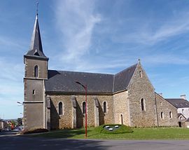 The church of Saint-Symphorien, in Moulins-le-Carbonnel | |
 Coat of arms | |
show Location of Moulins-le-Carbonnel | |
 Moulins-le-Carbonnel | |
| Coordinates: 48°22′24″N 0°01′23″W / 48.3733°N 0.0231°WCoordinates: 48°22′24″N 0°01′23″W / 48.3733°N 0.0231°W | |
| Country | France |
| Region | Pays de la Loire |
| Department | Sarthe |
| Arrondissement | Mamers |
| Canton | Sillé-le-Guillaume |
| Intercommunality | Haute Sarthe Alpes Mancelles |
| Government | |
| • Mayor (2020–2026) | Stéphanie Bouquet[1] |
| Area 1 | 16.31 km2 (6.30 sq mi) |
| Population (Jan. 2018)[2] | 700 |
| • Density | 43/km2 (110/sq mi) |
| Demonym(s) | Moulinois |
| Time zone | UTC+01:00 (CET) |
| • Summer (DST) | UTC+02:00 (CEST) |
| INSEE/Postal code | 72212 /72130 |
| Elevation | 118–223 m (387–732 ft) |
| 1 French Land Register data, which excludes lakes, ponds, glaciers > 1 km2 (0.386 sq mi or 247 acres) and river estuaries. | |


Moulins-le-Carbonnel is a commune in the Sarthe department in the region of Pays de la Loire in north-western France.
See also[]
- Communes of the Sarthe department
- Parc naturel régional Normandie-Maine
References[]
- ^ "Répertoire national des élus: les maires". data.gouv.fr, Plateforme ouverte des données publiques françaises (in French). 2 December 2020.
- ^ "Populations légales 2018". INSEE. 28 December 2020.
| Wikimedia Commons has media related to Moulins-le-Carbonnel. |
| show Communes of the Sarthe department |
|---|
This Sarthe geographical article is a stub. You can help Wikipedia by . |
Categories:
- Communes of Sarthe
- Sarthe geography stubs