Quemigny-sur-Seine
From Wikipedia, the free encyclopedia
Commune in Bourgogne-Franche-Comté, France
Quemigny-sur-Seine | |
|---|---|
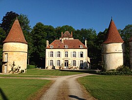 Chateau | |
 Coat of arms | |
 Quemigny-sur-Seine  Quemigny-sur-Seine | |
| Coordinates: 47°39′47″N 4°40′05″E / 47.6631°N 4.6681°E / 47.6631; 4.6681Coordinates: 47°39′47″N 4°40′05″E / 47.6631°N 4.6681°E / 47.6631; 4.6681 | |
| Country | France |
| Region | Bourgogne-Franche-Comté |
| Department | Côte-d'Or |
| Arrondissement | Montbard |
| Canton | Châtillon-sur-Seine |
| Intercommunality | Pays Châtillonnais |
| Government | |
| • Mayor (2008–2014) | Gilbert Jager |
| Area 1 | 21.34 km2 (8.24 sq mi) |
| Population (Jan. 2018)[1] | 103 |
| • Density | 4.8/km2 (13/sq mi) |
| Time zone | UTC+01:00 (CET) |
| • Summer (DST) | UTC+02:00 (CEST) |
| INSEE/Postal code | 21514 /21510 |
| Elevation | 285–422 m (935–1,385 ft) (avg. 350 m or 1,150 ft) |
| 1 French Land Register data, which excludes lakes, ponds, glaciers > 1 km2 (0.386 sq mi or 247 acres) and river estuaries. | |

Quemigny-sur-Seine is a commune in the Côte-d'Or department in eastern France.
Population[]
| Year | Pop. | ±% |
|---|---|---|
| 1962 | 230 | — |
| 1968 | 195 | −15.2% |
| 1975 | 151 | −22.6% |
| 1982 | 130 | −13.9% |
| 1990 | 136 | +4.6% |
| 1999 | 131 | −3.7% |
| 2008 | 116 | −11.5% |
See also[]
References[]
- ^ "Populations légales 2018". INSEE. 28 December 2020.
| Wikimedia Commons has media related to Quemigny-sur-Seine. |
| show | |
|---|---|
|
| show Authority control | |
|---|---|
| General |
|
| National libraries | |
Retrieved from ""
Categories:
- Communes of Côte-d'Or
- Côte-d'Or geography stubs
Hidden categories:
- Articles with short description
- Short description is different from Wikidata
- Infobox mapframe without OSM relation ID on Wikidata
- Coordinates on Wikidata
- Pages using infobox settlement with image map1 but not image map
- Commons category link from Wikidata
- Articles with VIAF identifiers
- Articles with BNF identifiers
- Articles with WorldCat-VIAF identifiers
- All stub articles
- Pages using the Kartographer extension