Rochefourchat
This article needs additional citations for verification. (December 2014) |
Rochefourchat | |
|---|---|
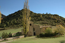 The church of Saint-Pierre | |
show Location of Rochefourchat | |
 Rochefourchat | |
| Coordinates: 44°35′58″N 5°14′53″E / 44.5994°N 5.2481°ECoordinates: 44°35′58″N 5°14′53″E / 44.5994°N 5.2481°E | |
| Country | France |
| Region | Auvergne-Rhône-Alpes |
| Department | Drôme |
| Arrondissement | Die |
| Canton | Le Diois |
| Intercommunality | |
| Government | |
| • Mayor (2020–2026) | Jean-Baptiste Le Moyne de Martigny[1] |
| Area 1 | 12.74 km2 (4.92 sq mi) |
| Population (Jan. 2018)[2] | 1 |
| • Density | 0.078/km2 (0.20/sq mi) |
| Time zone | UTC+01:00 (CET) |
| • Summer (DST) | UTC+02:00 (CEST) |
| INSEE/Postal code | 26274 /26340 |
| Elevation | 600–1,513 m (1,969–4,964 ft) (avg. 963 m or 3,159 ft) |
| 1 French Land Register data, which excludes lakes, ponds, glaciers > 1 km2 (0.386 sq mi or 247 acres) and river estuaries. | |


Rochefourchat (French pronunciation: [ʁɔʃ.fuʁʃa]) is a commune in the Drôme department in the Auvergne-Rhône-Alpes region in southeastern France. In the commune there is a single house, the church of Saint-Pierre, a converted barn, and the ruins of an old castle. The nearest communes to Rochefourchat are Saint-Nazaire-le-Désert, Les Tonils, Pradelle, and Brette.
History[]
In 1178, the castle of Rocha Forcha was built by the bishops of the arrondissement of Die as a stronghold against the Holy Roman Emperors. It belonged to French lords until the year 1766 when the last one, , died. In 1796, a French trader, bought the land surrounding the castle and renamed it Rochefourchat. The commune has been passed down through Jossaud's family.
Population[]
| Year | Pop. | ±% |
|---|---|---|
| 1982 | 3 | — |
| 1990 | 2 | −33.3% |
| 1999 | 1 | −50.0% |
| 2006 | 1 | +0.0% |
| 2007 | 1 | +0.0% |
| 2008 | 1 | +0.0% |
| 2009 | 1 | +0.0% |
| 2010 | 1 | +0.0% |
| 2011 | 1 | +0.0% |
| 2012 | 1 | +0.0% |
| 2013 | 1 | +0.0% |
| 2014 | 1 | +0.0% |
| 2015 | 1 | +0.0% |
| 2016 | 1 | +0.0% |
| 2018 | 1 | +0.0% |
There is only one permanent inhabitant. This does not, however, make Rochefourchat the least populous French commune, as there are six communes without any inhabitant: they were destroyed and abandoned during World War I, and maintained as administrative subdivisions for memorial reasons.
See also[]
References[]
- ^ "Répertoire national des élus: les maires". data.gouv.fr, Plateforme ouverte des données publiques françaises (in French). 2 December 2020.
- ^ "Populations légales 2018". INSEE. 28 December 2020.
External links[]
| Wikimedia Commons has media related to Rochefourchat. |
- Communes of Drôme