Rouperroux-le-Coquet
Rouperroux-le-Coquet | |
|---|---|
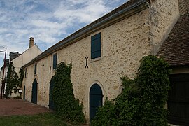 An old barn in the centre of the village | |
show Location of Rouperroux-le-Coquet | |
 Rouperroux-le-Coquet | |
| Coordinates: 48°13′38″N 0°25′53″E / 48.2272°N 0.4314°ECoordinates: 48°13′38″N 0°25′53″E / 48.2272°N 0.4314°E | |
| Country | France |
| Region | Pays de la Loire |
| Department | Sarthe |
| Arrondissement | Mamers |
| Canton | Bonnétable |
| Intercommunality | Maine Saosnois |
| Government | |
| • Mayor (2020–2026) | Pascal Champclou[1] |
| Area 1 | 10.27 km2 (3.97 sq mi) |
| Population (Jan. 2018)[2] | 287 |
| • Density | 28/km2 (72/sq mi) |
| Demonym(s) | Coqueroupéen, Coqueroupéenne |
| Time zone | UTC+01:00 (CET) |
| • Summer (DST) | UTC+02:00 (CEST) |
| INSEE/Postal code | 72259 /72110 |
| Elevation | 72–133 m (236–436 ft) |
| 1 French Land Register data, which excludes lakes, ponds, glaciers > 1 km2 (0.386 sq mi or 247 acres) and river estuaries. | |


Rouperroux-le-Coquet is a commune in the Sarthe department in the Pays de la Loire region in north-western France.
See also[]
- Communes of the Sarthe department
References[]
- ^ "Répertoire national des élus: les maires". data.gouv.fr, Plateforme ouverte des données publiques françaises (in French). 2 December 2020.
- ^ "Populations légales 2018". INSEE. 28 December 2020.
| Wikimedia Commons has media related to Rouperroux-le-Coquet. |
| show Communes of the Sarthe department |
|---|
| show Authority control |
|---|
This Sarthe geographical article is a stub. You can help Wikipedia by . |
Categories:
- Communes of Sarthe
- Sarthe geography stubs