Saint-Sauveur-Camprieu
Saint-Sauveur-Camprieu | |
|---|---|
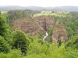 Bramabiau Gorge | |
 Coat of arms | |
show Location of Saint-Sauveur-Camprieu | |
 Saint-Sauveur-Camprieu | |
| Coordinates: 44°07′00″N 3°28′41″E / 44.1167°N 3.4781°ECoordinates: 44°07′00″N 3°28′41″E / 44.1167°N 3.4781°E | |
| Country | France |
| Region | Occitanie |
| Department | Gard |
| Arrondissement | Le Vigan |
| Canton | Le Vigan |
| Government | |
| • Mayor (2020–2026) | Nicole Amasse |
| Area 1 | 31.74 km2 (12.25 sq mi) |
| Population (Jan. 2018)[1] | 234 |
| • Density | 7.4/km2 (19/sq mi) |
| Time zone | UTC+01:00 (CET) |
| • Summer (DST) | UTC+02:00 (CEST) |
| INSEE/Postal code | 30297 /30750 |
| Elevation | 783–1,402 m (2,569–4,600 ft) (avg. 1,112 m or 3,648 ft) |
| 1 French Land Register data, which excludes lakes, ponds, glaciers > 1 km2 (0.386 sq mi or 247 acres) and river estuaries. | |


Saint-Sauveur-Camprieu (French pronunciation: [sɛ̃ sovœʁ kɑ̃pʁijø]; Occitan: Sent Sauvaire e Camriu) is a commune in the Gard department in southern France.
Population[]
| Year | Pop. | ±% |
|---|---|---|
| 171 | 1,968 | — |
| 218 | 1,975 | +0.4% |
| 204 | 1,982 | +0.4% |
| 201 | 1,990 | +0.4% |
| 198 | 1,999 | +0.5% |
| 188 | 2,008 | +0.5% |
| 268 | — |
Sights[]
- Bramabiau Gorge
- Arboretum de Saint-Sauveur-des-Pourcils
See also[]
- Communes of the Gard department
References[]
- ^ "Populations légales 2018". INSEE. 28 December 2020.
| Wikimedia Commons has media related to Saint-Sauveur-Camprieu. |
| show Communes of the Gard department |
|---|
| show Authority control |
|---|
This Gard geographical article is a stub. You can help Wikipedia by . |
Categories:
- Communes of Gard
- Gard geography stubs