Surigao City
Surigao City | |
|---|---|
Component city | |
| City of Surigao | |
 City Hall | |
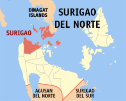 Map of Surigao del Norte with Surigao City highlighted | |
 Surigao City Location within the Philippines | |
| Coordinates: 9°47′N 125°29′E / 9.78°N 125.48°ECoordinates: 9°47′N 125°29′E / 9.78°N 125.48°E | |
| Country | Philippines |
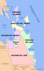
| Region | Caraga |
| Province | Surigao del Norte |
| District | 2nd district |
| Founded | June 29, 1655 |
| Cityhood | August 31, 1970 |
| Barangays | 54 (see Barangays) |
| Government | |
| • Type | Sangguniang Panlungsod |
| • Mayor | Ernesto "Estong" U. Matugas Jr. |
| • Vice Mayor | Ernesto T. Matugas |
| • Representative | Robert Ace S. Barbers |
| • Electorate | 103,688 voters (2019) |
| Area | |
| • Total | 245.30 km2 (94.71 sq mi) |
| Elevation | 43 m (141 ft) |
| Highest elevation | 984 m (3,228 ft) |
| Lowest elevation | 0 m (0 ft) |
| Population (2020 census) [3] | |
| • Total | 171,107 |
| • Density | 700/km2 (1,800/sq mi) |
| • Households | 34,572 |
| Economy | |
| • Income class | 3rd city income class |
| • Poverty incidence | 29.36% (2015)[4] |
| • Revenue | ₱678,256,607.49 (2016) |
| Service provider | |
| • Electricity | Surigao del Norte Electric Cooperative (SURNECO) |
| Time zone | UTC+08:00 (PST) |
| ZIP code | 8400 |
| PSGC | |
| IDD : area code | +63 (0)86 |
| Climate type | tropical rainforest climate |
| Native languages | Surigaonon Agusan Cebuano Tagalog |
| Website | www |

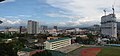
Surigao City, officially the City of Surigao (Surigaonon: Siyudad nan Surigao; Cebuano: Dakbayan sa Surigao; Tagalog: Lungsod ng Surigao), is a 3rd class component city and capital of the province of Surigao del Norte, Philippines. According to the 2020 census, it has a population of 171,107 people. [3]
Located at the north-easternmost tip of Mindanao, it has a total land area of 245.34 km2 which is roughly 1.4% of Caraga region.
The absence of a fort in Surigao belies its significance and sphere of influence during the Spanish period. It was the capital of the expansive province of the same name from 1750 until its dissolution in 1911, covering a third of Mindanao Island's total land area. It is one of the oldest port towns in Mindanao, founded by Spanish colonizers in 1655. It has abundant mineral reserves including gold, iron, manganese, silica, cobalt, copper, chromite and among the world's largest nickel deposits in Nonoc Island. The Asian Institute of Management ranks the city as among the most competitive small-sized cities in the Philippines, with an estimated total income of 600 million pesos in 2012.
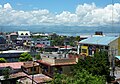
The city serves as a jump off point to visitors of nearby Siargao, Dinagat and Bucas Grande islands. It is Mindanao's closest landmass to the Visayas region. Eleven nautical miles across Surigao Strait separates the city from Panaon Island in the Visayas. Surigao is the center of politics, commerce, banking, industry and education of Surigao del Norte and Dinagat Islands as well as parts of neighboring provinces of Surigao del Sur, Agusan del Norte and Southern Leyte.
Etymology[]
There are two hypotheses on the original meaning of "Surigao" among linguists, depending on the original root word. If the root word was taken to be sulig ("sprout" or "spring up"), then Surigao may have derived from suligao ("spring water"), likely referring to the Surigao River (known as "Suligaw" in Mandaya) that empties at the northern tip of the island of Mindanao.[5][6] Early historical accounts record the name of the river as Suligao, Surigao, or Zurigan.[7]
Another possibility is that it is derived from Visayan surogao or suyogao, meaning "water current". From suyog (also sulog or surog), "current". Other Visayan words derived from the same root include Sinulog, Sulu, and Tausug (Suluk).[8]
There is also a popular legend about Visayan fishermen who went adrift on a stormy day at the mouth of today's Surigao River. With boats wrecked, they were unable to sail back to sea. They were met by a docile village chieftain named Solibao who offered them his abode. The fishermen helped the chieftain procure food for the village's daily subsistence in exchange for his hospitality. One day, with much luck, they were able to paddle back home with the help of other fisherman who made it to the village they now named Solibao. Some of the men eventually returned and settled in the area. During the 15th century, Spanish galleons dropped anchor near the settlement and came ashore. The Spanish historian, worn from the long transpacific journey misheard the people when he asked where they were, and instead wrote in his diaries Surigao, referring to the land at the north-easternmost tip of Mindanao Island.
The town was renamed Caraga after its founding, derived from the word calagan, from the Kalagan people, whose name means "people of the [fierce/brave] spirit". The Italian adventurer Giovanni Francesco Gemelli Careri, who published a book of travel in the country, cited Francisco Combes, S.J. as a source in saying that Calagan is derived from the two Visayan words, kalag for soul and an for people. Today, Caraga is the official name referring to the entire Region XIII, created through Republic Act No. 7901 on February 25, 1995, making it the newest region in the Philippines.
History[]

The site around Surigao was settled early on, even before the Spanish conquest. Fishing villages dotted along the coast facing the Hinatuan Passage while Mamanwa tribes inhabited the interior highlands. The confluence of three major bodies of water- Pacific Ocean, Surigao Strait and Mindanao Sea, kept the area inhabited continuously for many centuries, although its historical importance waxed and waned as other parts of the archipelago were explored and developed.
Spanish Era[]
Ferdinand Magellan sailed into the Philippine Archipelago, reaching the island of Homonhon in an epic voyage of discovery and eventual circumnavigation of the world in 1521. Magellan's fleet proceeded to Limasawa through Surigao Strait, a notch north-west of the city's pelagic boundaries, before dropping anchor on the waters off the island of Cebu, ushering the Spanish colonization of the Philippines.

Present day Surigao originated from a site in the city proper formerly known as Bilang-Bilang where it served as a port of call for inter-island vessels. It was renamed Banahao which became an integral part of the old district of Caraga, a town founded on June 29, 1655. After Caolo, present day Siargao, burned in 1750, Surigao became the capital of the expansive geopolitical, eclessiastical and military district of Surigao which reached the fringes of Davao and would include today's provinces of Surigao del Sur, Agusan del Norte, Agusan del Sur, parts of Compostela Valley, Misamis Oriental, Davao del Norte and Davao Oriental. It officially became the permanent residence of the Augustinian Recollects on February 1, 1752, when all the canonical books were moved from Caolo to Surigao. The first canonical books bore the signature of Fr. Lucas de la Cruz. Previously, the place was just a "vista" of the parish in Caolo. Its strategic location and new status as the seat of government was costly. Surigao witnessed violent territorial struggles as it suffered ultimately from relentless Moro raids. In 1752, the town was devastated. Most of its 2,000 inhabitants were either killed or taken as slaves by the Moros.

First and Official Flag Raising in Mindanao. Father Alberto Masoliver, S.J., during his stint as the parish priest of Surigao in 1898, kept a compilation of his diaries, entitled Diario de la Casa de Surigao. His diaries are currently stored in the Jesuit archives at Centro Borja, Sant Cugat del Valles, Spain. He thus wrote on December 26, 1898, "Before 10:00 AM, the tri-color was hoisted from Casa Real seat of provincial government) and the Tribunal … without any formalities … without anybody's attention being drawn…..these people have no idea of what it is all about, and if they have… how peaceful and without malice they are.". Surigao then was the cabecera and the seat of government of the province of Caraga which had jurisdiction over Surigao, Butuan and Cagayan de Misamis (Cagayan de Oro). Alejandro (Jantoy) Gonzalez was the president of the Junta Provincial of Surigao during the time of the first flag hoisting.
- Controversy about the location of the First Philippine Flag Raising in Mindanao. The Philippines' National Historical Institute carries the mandate to decide on historical matters and to erect national markers. In a roundtable held in January 2000, the historians decided that the raising of the flag on December 26, 1898, by Alejandro Gonzalez in Surigao was duly sanctioned by Emilio Aguinaldo's government. The installation of the NHI marker in Surigao City followed suit.[1]
American Period[]
At the turn of the century in 1901, the American colonizers established a civil government in the province of Surigao, keeping the town of Surigao as its capital. Surigao was then among the largest municipalities in land area with a jurisdiction of 949.90 square kilometers, larger than today's Butuan. During this period, there was only one main road, the Old Spanish road. The commercial district, market and plaza (Luneta) were all situated in one small area. In 1930, the Old Spanish road was abandoned and a new provincial road was constructed. The Casa Real was built where municipal administrators would hold their official functions. Surigao's core barrios- Taft and Washington, were named after United States presidents William Howard Taft and George Washington.
World War II[]
Surigao featured prominently in World War II's Pacific theater. On May 23, 1942, the Japanese Imperial Army under Colonel Yoshie occupied Surigao after arriving from Butuan. They formally took over on May 28, 1942, under Lieutenant Ichichara, taking control from Mayor Amat. Filipino guerrilla units based in Surigao continued to operate in the hinterlands. Liberation from the Japanese rule dawned on September 9, 1944. American planes started their campaign by bombing the town in the early morning. It was followed by a strafing of all Japanese warships docked at the Surigao wharf, which came to transport fresh troops and supplies to their forces in Leyte. No less than fifty warships were sunk by the raiding American bomber planes. After the attack, not a single Japanese ship was seen afloat. The following month, on October 24–25, the famous Battle of Surigao Strait, the final line battle in naval history, was fiercely fought by allied forces against the Japanese fleet. By April 12, 1945, the whole province of Surigao was liberated from Japanese occupation.
One American family who had lived in and near Surigao before the war returned after the Japanese left the area in 1945. Virginia Holmes, a child in 1945, many years later wrote, "We were shocked at the destruction the war years had wrought. Many houses stood empty, and others were mere skeletons. Walls were pockmarked with bullet holes. There were piles of rubble everywhere. The tree-lined streets that used to be so pretty were now full of potholes, and only a few trees were left undamaged."[9] Holmes said the cemetery had been neglected and at least part of it was overgrown in weeds.[10]
Post War Reconstruction[]
Massive reconstruction followed the destruction brought by the war. The Surigao Provincial Capitol was completed in 1946 atop the hill overlooking the city. Other facilities were built including schools, athletic field and municipal jail. In 1948, the first election of municipal officials was held. In the same year, construction of the Surigao Provincial Hospital commenced. Six years later in 1954, construction of the first municipal building started and was completed in 1955. Economic activities continued to flourish with the launching of gold mining operations by Mindanao Mother Lode Mines in Mabuhay, 10 kilometers away from the city. Rapid economic growth and immigration resulted to losing some of its fishing and agricultural barrios as they were converted into towns of Malimono (July 31, 1956), San Francisco (May 24, 1957) and Sison (September 15, 1959). During the same year, settlements including Capalayan, Libuac, Catadman, Mat-i, Lipata, Dakung Patag, Bunyasan, Cantapoy, Balite, and Bambanon were elevated into barrios, the forerunner of modern-day barangays.[11] At that time, Surigao was classified as a 1st Class B municipality with an annual income of P160,000.00 and a population of nearly 50,000. It was primarily an agricultural town producing mainly copra and basic staples including rice, corn, bananas and rootcrops. Fishing was also a major source of livelihood. On September 18, 1960, pursuant to the Republic Act 2786 dated June 19, 1960, the province of Surigao was divided into Surigao del Norte and Surigao del Sur.[12] The town of Surigao remained as a capital, this time for the province of Surigao del Norte.
Surigao was on a rapid growth path. Already, it had a domestic airport, three movie houses, three hotels and two hospitals. However, on November 19, 1964, tragedy befell the town as it saw its most massive destruction yet. It was in the direct path of supertyphoon Ining, internationally code-named Louise-Marge, with peak winds at 240 kilometers per hour. The wrath of the storm was severe and devastation wide, both in infrastructure and human lives. Just as they overcame the destruction of war, the locals tenacity was again proven in the town's rebuilding. In a short time, after three years in 1967, Pacific Cement Corporation [2] started commercial operations in Mabuhay, Sison, producing among the highest quality cement in the country. In 1969, Marinduque Mining Industrial Corporation started nickel exploration in Nonoc Island with an initial capitalization of Php1.0 billion pesos, ushering a new era of prosperity.
Cityhood[]
Pursuant to Republic Act No. 6134, Surigao was converted to a chartered city on August 31, 1970, with Pedro Espina as its first city mayor.
Geography[]
Surigao City is situated at the north-easternmost tip of Mindanao Island. It is bounded by Municipalities of Dinagat and Basilisa to the north, Philippine Sea and the Municipality of Cagdianao to the east, Municipalities of Sison and Tagana-an to the south, Mindanao Sea and the Municipality of San Francisco to the west and the Surigao Strait to the north-west.
Topography[]
Surigao City is marked by rolling hills that gently buffers its eastern and western boundaries. To the south-west towers the Kabangkaan Ridge which divides the city from the municipality of San Francisco (formerly Anao-aon). Kinabutan River (otherwise known as Surigao River) meanders Surigao valley before it empties to the Surigao tidal basin, a shrinking mangrove swamp fast overtaken by the city's expansion. It has an average elevation of 19 meters or 65.5 ft. above sea level. The highest elevation on the mainland at the Kabangkaan Ridge has a peak elevation of 465 meters above sea level. Along the border of Tagana-an is Mapawa Peak with an elevation of 245 meters above sea level. Barangays Cabongbongan, Nabago and Capalayan are at the foot of its slopes.
More than two dozen islands and islets make up two fifths of the city's total land area. They are separated from the mainland by Hinatuan Passage, which connects Mindanao Sea to the Pacific Ocean. The largest island of Nonoc is marked by a rusty-red weathering mantle of lateritic nickel ore, visible from any vantage point on the mainland coast. Its highest elevation at 263 meters above sea level typifies most of its hilly terrain. Across the channel at Hikdop Island, the highest point is Mt. Telegrapo at 100.05 meters. Hinatuan Island is similar to Nonoc's bare and rusty-red hilly appearance. Other notable islands of Hanigad, Sibale, Bayaganan and Awasan are generally flat, covered mostly with coconut trees and assorted hardwoods. Large swaths of mangrove and nipa palm forests cover its brackish waterways and shallow fringes of its coastlines.
Climate[]
| hideClimate data for Surigao City (1981–2010, extremes 1903–2012) | |||||||||||||
|---|---|---|---|---|---|---|---|---|---|---|---|---|---|
| Month | Jan | Feb | Mar | Apr | May | Jun | Jul | Aug | Sep | Oct | Nov | Dec | Year |
| Record high °C (°F) | 33.7 (92.7) |
33.3 (91.9) |
35.0 (95.0) |
35.2 (95.4) |
36.3 (97.3) |
37.5 (99.5) |
36.2 (97.2) |
37.0 (98.6) |
38.2 (100.8) |
35.6 (96.1) |
36.5 (97.7) |
34.6 (94.3) |
37.5 (99.5) |
| Average high °C (°F) | 29.4 (84.9) |
29.9 (85.8) |
30.8 (87.4) |
32.0 (89.6) |
32.7 (90.9) |
32.6 (90.7) |
32.3 (90.1) |
32.7 (90.9) |
32.7 (90.9) |
32.0 (89.6) |
30.8 (87.4) |
29.9 (85.8) |
31.5 (88.7) |
| Daily mean °C (°F) | 26.3 (79.3) |
26.7 (80.1) |
27.3 (81.1) |
28.2 (82.8) |
28.8 (83.8) |
28.7 (83.7) |
28.5 (83.3) |
28.7 (83.7) |
28.7 (83.7) |
28.2 (82.8) |
27.4 (81.3) |
26.8 (80.2) |
27.9 (82.2) |
| Average low °C (°F) | 23.3 (73.9) |
23.5 (74.3) |
23.8 (74.8) |
24.4 (75.9) |
24.9 (76.8) |
24.8 (76.6) |
24.6 (76.3) |
24.7 (76.5) |
24.6 (76.3) |
24.4 (75.9) |
24.0 (75.2) |
23.7 (74.7) |
24.2 (75.6) |
| Record low °C (°F) | 18.6 (65.5) |
18.2 (64.8) |
18.8 (65.8) |
18.9 (66.0) |
20.8 (69.4) |
20.7 (69.3) |
20.0 (68.0) |
20.0 (68.0) |
20.6 (69.1) |
20.5 (68.9) |
19.7 (67.5) |
19.1 (66.4) |
18.2 (64.8) |
| Average rainfall mm (inches) | 609.4 (23.99) |
446.4 (17.57) |
326.0 (12.83) |
219.1 (8.63) |
139.6 (5.50) |
142.1 (5.59) |
171.1 (6.74) |
133.9 (5.27) |
171.0 (6.73) |
240.7 (9.48) |
467.3 (18.40) |
585.2 (23.04) |
3,651.8 (143.77) |
| Average rainy days (≥ 0.1 mm) | 26 | 21 | 21 | 17 | 13 | 14 | 15 | 12 | 15 | 19 | 22 | 25 | 220 |
| Average relative humidity (%) | 88 | 86 | 84 | 83 | 81 | 81 | 81 | 80 | 80 | 82 | 86 | 87 | 83 |
| Source: PAGASA[13][14] | |||||||||||||
Like most of the country, Surigao is officially considered a tropical rainforest climate type, Köppen class Af with an average monthly precipitation of 308.66 mm (12.5 inches). It is distinctly wettest between the months of November until March. During the drier season between April to September, brief afternoon showers and thunderstorms locally called sobasco, are commonplace.
Barangays[]
Surigao City is subdivided into 54 barangays, 33 in the mainland and 21 in the islands. Of the 36 coastal barangays, 15 are in the mainland and 20 are in the islands. The urban area covers 15 barangays or approximately 20% of the total land area. These include Taft, Washington, San Juan, Sabang, Canlanipa, Cagniog, Luna, Togbongon, Rizal, Lipata, Punta Bilar, Mabua and Ipil.
The 21 island barangays are Alang-Alang, Alegria, Aurora, Baybay, Bilabid, Bitaugan, Buenavista, Cagutsan, Cantiasay, Catadman, Danawan, Libuac, Lisondra, Manjagao, Nonoc, San Jose, Sidlakan, Sugbay, Talisay, and Zaragoza.
- Alang-alang
- Alegria
- Anomar
- Aurora
- Balibayon
- Baybay
- Bilabid
- Bitaugan
- Bonifacio
- Buenavista
- Cabongbongan
- Cagniog
- Cagutsan
- Canlanipa
- Cantiasay
- Capalayan
- Catadman
- Danao
- Danawan
- Day-asan
- Ipil
- Libuac
- Lipata
- Lisondra
- Luna
- Mabini
- Mabua
- Manjagao
- Mapawa
- Mat-i
- Nabago
- Nonoc
- Orok
- Poctoy
- Punta Bilar
- Quezon
- Rizal
- Sabang
- San Isidro
- San Jose
- San Juan
- San Pedro (Hanigad)
- San Roque
- Serna (Bad-asay)
- Sidlakan
- Silop
- Sugbay
- Sukailang
- Taft
- Talisay
- Togbongon
- Trinidad
- Washington
- Zaragoza
Demographics[]
| Year | Pop. | ±% p.a. |
|---|---|---|
| 1903 | 8,606 | — |
| 1918 | 16,232 | +4.32% |
| 1939 | 34,339 | +3.63% |
| 1948 | 46,109 | +3.33% |
| 1960 | 37,439 | −1.72% |
| 1970 | 51,496 | +3.24% |
| 1975 | 66,027 | +5.11% |
| 1980 | 79,745 | +3.85% |
| 1990 | 100,379 | +2.33% |
| 1995 | 104,909 | +0.83% |
| 2000 | 118,534 | +2.65% |
| 2007 | 132,151 | +1.51% |
| 2010 | 140,540 | +2.27% |
| 2015 | 154,137 | +1.77% |
| 2020 | 171,107 | +2.07% |
| Source: Philippine Statistics Authority [15] [16] [17][18] | ||
The demographics of Surigao City are evidence of an ethnically diverse city. Throughout its history, Surigao has been a point of entry for migrants from other regions of the Philippines, enticed by the city's political significance, attractive natural setting, abundant resources and during the last century, increased mining operations. Butuanons, Hiligaynons, Warays, Cebuanos and other ethnic groups found home in Surigao and eventually learned how to speak the language. Some of their descendants now hold prominent positions in the city and provincial governments. Migrants from China also found home in Surigao; their direct descendants now comprise the bulk of successful merchants of the Surigao business community.
Surigao is home to one of the country's oldest and most colorful tribes, the Mamanwa. They are similar to the Negritoes of Luzon in features and stature. They are generally short, dark-skinned with a crop of short kinky hair. Forced to settle in the hinterlands due to development, they continued to practice their customs and traditions. The faith about Kahimunan, one of their many tribal festivities, highlights music and graceful dancing. Revelers chant and play while accompanied by native musical instruments including the gimbar (drum), gong and bamboo percussion called kalatong and katik. Wild pigs, chicken and indigenous fruits including the rare kayape are among the offerings. A baylan (priest) presides the celebration as a tribute and invocation to their god Magbabaya and departed ancestors for good health and abundant harvest.
Mamanwas are also known for their creative patterns, brass jewelries and indigenous crafts, displayed proudly on their costumes as they fill the streets at the height of the Bonok Bonok Maradjao Karadjao Festival every September 9, celebrated on the occasion of the feast of Saint Nicolas de Tolentino, Surigao City's patron saint. Bonok-bonok and its prehistoric origins was another ritual to thank their gods, presided by various village chieftains and their wives. Happiness and friendship are expressed through dancing, chanting and singing. They wave scarves of banay as symbols of goodwill, wealth and blessings for all tribal villages.
Today, most of the Mamanwas still live in the hinterlands, occasionally descending to town to sell or barter handicrafts and fresh harvest. Bands still subsist on foraging even as majority of them have adopted a more modern way of life over the years.
Barangays[]
| Barangay | population
Percentage (2020) |
population
(2020) |
Population
(2015) |
Change
(2015-2020) |
Annual Population
Growth Rate (2015-2020) |
|---|---|---|---|---|---|
| Alang-alang | 0.25% | 436 | 405 | 7.65% | 1.56% |
| Alegria | 0.36% | 623 | 574 | 8.54% | 1.74% |
| Anomar | 1.12% | 1,908 | 1,727 | 10.48% | 2.12% |
| Aurora | 0.43% | 736 | 677 | 8.71% | 1.77% |
| Balibayon | 1.30% | 2,216 | 1,752 | 26.48% | 5.07% |
| Baybay | 0.18% | 311 | 330 | -5.76% | -1.24% |
| Bilabid | 0.14% | 241 | 293 | -17.75% | -4.03% |
| Bitaugan | 0.41% | 707 | 637 | 10.99% | 2.22% |
| Bonifacio | 2.23% | 3,822 | 3,534 | 8.15% | 1.66% |
| Buenavista | 0.68% | 1,168 | 916 | 27.51% | 5.25% |
| Cabongbongan | 0.49% | 841 | 905 | -7.07% | -1.53% |
| Cagniog | 3.87% | 6,622 | 5,225 | 26.74% | 5.11% |
| Cagutsan | 0.20% | 342 | 345 | -0.87% | -0.18% |
| Canlanipa | 6.80% | 11,636 | 9,697 | 20.00% | 3.91% |
| Cantiasay | 0.61% | 1,047 | 984 | 6.40% | 1.31% |
| Capalayan | 1.56% | 2,672 | 2,502 | 6.79% | 1.39% |
| Catadman | 0.20% | 350 | 382 | -8.38% | -1.82% |
| Danao | 0.39% | 669 | 593 | 12.82% | 2.57% |
| Danawan | 0.36% | 620 | 573 | 8.20% | 1.67% |
| Day-asan | 1.19% | 2,032 | 1,883 | 7.91% | 1.62% |
| Ipil | 2.74% | 4,692 | 4,323 | 8.54% | 1.74% |
| Libuac | 0.58% | 997 | 949 | 5.06% | 1.04% |
| Lipata | 1.68% | 2,872 | 2,653 | 8.25% | 1.68% |
| Lisondra | 0.50% | 858 | 882 | -2.72% | -0.58% |
| Luna | 7.73% | 13,233 | 10,425 | 26.94% | 5.15% |
| Mabini | 1.37% | 2,347 | 2,337 | 0.43% | 0.09% |
| Mabua | 1.97% | 3,363 | 2,778 | 21.06% | 4.10% |
| Manyagao | 0.56% | 956 | 851 | 12.34% | 2.48% |
| Mapawa | 0.74% | 1,270 | 1,132 | 12.19% | 2.45% |
| Mat-i | 3.87% | 6,617 | 5,722 | 15.64% | 3.11% |
| Nabago | 0.68% | 1,167 | 1,143 | 2.10% | 0.44% |
| Nonoc | 0.65% | 1,107 | 1,310 | -15.50% | -3.48% |
| Orok | 0.80% | 1,372 | 1,114 | 23.16% | 4.48% |
| Poctoy | 1.16% | 1,991 | 1,688 | 17.95% | 3.54% |
| Punta Bilar | 0.80% | 1,371 | 1,079 | 27.06% | 5.17% |
| Quezon | 1.37% | 2,339 | 2,229 | 4.93% | 1.02% |
| Rizal | 4.38% | 7,492 | 6,659 | 12.51% | 2.51% |
| Sabang | 3.57% | 6,114 | 4,705 | 29.95% | 5.67% |
| San Isidro | 0.37% | 629 | 586 | 7.34% | 1.50% |
| San Jose | 0.79% | 1,356 | 1,265 | 7.19% | 1.47% |
| San Juan | 9.68% | 16,565 | 14,925 | 10.99% | 2.22% |
| San Pedro | 0.54% | 919 | 865 | 6.24% | 1.28% |
| San Roque | 0.93% | 1,596 | 1,444 | 10.53% | 2.13% |
| Serna | 0.99% | 1,701 | 1,438 | 18.29% | 3.60% |
| Sidlakan | 0.19% | 331 | 307 | 7.82% | 1.60% |
| Silop | 0.94% | 1,602 | 1,485 | 7.88% | 1.61% |
| Sugbay | 0.32% | 554 | 482 | 14.94% | 2.97% |
| Sukailang | 0.82% | 1,396 | 1,386 | 0.72% | 0.15% |
| Taft | 11.25% | 19,242 | 18,571 | 3.61% | 0.75% |
| Talisay | 0.68% | 1,166 | 1,403 | -16.89% | -3.82% |
| Togbongon | 1.32% | 2,257 | 2,105 | 7.22% | 1.48% |
| Trinidad | 1.59% | 2,726 | 2,587 | 5.37% | 1.11% |
| Washington | 11.29% | 19,319 | 18,900 | 2.22% | 0.46% |
| Zaragoza | 0.35% | 591 | 475 | 24.42% | 4.71% |
| Surigao City Total | 171,107 | 154,137 | 11.01% | 2.22% | |
Language[]
Sinurigaonon, the official language in the city and province is unique among the Visayan languages. It is also spoken by the majority of the population in the province of Surigao del Sur and around Lake Mainit in Agusan del Norte. Similarities with the Cebuano language are undeniable, however, staunch Cebuano speakers can hardly understand people who speak Surigaonon. There is no doubt Surigaonon existed as pure and distinct, slowly pelted over time by Visayan words as migrants settled in the area. Today, Surigaonon is the most widely spoken language inherent in the eastern Caraga region.
Surigaonon has similar consonant and vowel sounds, stress, intonation patterns to the Cebuano language and Boholano dialect. Surigaonon underwent certain morphophonemic processes, such as assimilation, deletion, alternation and metathesis (Dumanig, 2005). In the study conducted by Dumanig (2005) on Descriptive Analysis of Surigaonon language it was found that there are 18 consonants (b,d,g,h,j,k,l,m,n,ng,p,r,s,t,w,y,o,?) with 18 sounds and 3 vowels (a,i,u) with 5 sounds. It has also 25 consonant clusters (br, bl, bw, by, dr, dy, dw, gr, gw, kr, kl, kw, mw, my, nw, pr, pl, pw, py, sw, sy, tr, tw, ty, hw) and 4 diphthongs (aw, ay, iw, uy), which are similar to the Cebuano language (Rubrico, 1999). There are Surigaonon words that are spelled similarly but they differ in meaning depending on how each syllable is stressed (Dumanig, 2005). Surigaonon language follows two intonation patterns like the rising and falling intonation. The rising intonation is common in asking yes or no questions and the falling intonation occurs in ending declarative and imperative statements (Dumanig, 2005)[3]
Economy[]
| Poverty Incidence of Surigao City | |
| Source: Philippine Statistics Authority[19][20][21][22][23][24] | |

Surigao City underwent rapid economic growth that spanned nearly two decades beginning in the late 1960s. Pacific Cement (PACEMCO) started commercial operations manufacturing Portland cement and the Canadian-owned company Marinduque Mining and Industrial Corporation (MMIC) also started extracting nickel and iron ore in Nonoc Island. This was a boon to the city as it generated commerce to meet increasing demand for goods and services. Towards the late 1970s, Surigao attained first class status. The rest of the province also saw increased mining operations, primarily extracting gold and copper. The city became the nexus of mining activity in the entire Northern Mindanao (Region X), at the time among Philippines' largest regions encompassing nearly half of Mindanao Island. Philippines' Bureau of Mines and Geosciences moved its regional headquarters in the city at Km. 1.
In 1983, MMIC ended commercial operations due to financial losses and heavy debt as a result of plummeting prices of nickel and high operating costs. Copra processing plant Surigao Coconut Development Corp. (SUCODECO) in Lipata also shut down. Surigao's weakened economy was further affected when typhoon Nitang (internationally codename Typhoon Ike) struck the city in September 1984. Seventy percent of the buildings and infrastructure were destroyed. Commercial activities declined, relying on basic services, small-scale industries, agriculture and fishing.
From the mid 80s until the turn of the 21st century, Surigao's economic woes mirrored the rest of the nation as it saw some of its original families leave for opportunities in other places, both local and overseas.
During the last decade, the city saw improvement of its key macroeconomic indicators. Increased retail activity was evident downtown as new stores opened and existing ones expanded. The success of major restaurant chains like Jollibee (3 branches as of mid-2020), Greenwich, Chowking (closed in 2014 but reopened in May 2016) and Mang Inasal opened the floodgates for more investments in the city. McDonald's also opened in March 2013 (after 5 years, it opened its second branch in October 2018) followed by Goldilocks in March 2015 and finally, the 2nd branch of Red Ribbon in June 2016. Shakey's Pizza opened its first doors at the ground floor of Gaisano Capital Mall in June 2019. Dunkin' Donuts and KFC were planned to open soon in the future. Hotel rooms doubled with the opening of new hotels and expansion of existing ones, with adequate convention facilities. Port expansion was completed in 2009, increasing its handling capacity. Today, it is one of the country's key seaports for gross registered tonnage handled, mainly from its mineral exports [4].
As of 2019, more than a total of 14 universal/banks such as Asia United Bank, Banco de Oro (BDO), Bank of the Philippine Islands (BPI), Chinabank, Development Bank of the Philippines (DBP), EastWest Bank, Land Bank of the Philippines (Landbank), Metrobank, Philippine National Bank (PNB), Rizal Commercial Banking Corporation (RCBC), Security Bank and United Coconut Planters Bank (UCPB), 6 thrift/savings banks and 3 rural banks are operating in the city along with 47 finance cooperatives, 52 pawnshops and 51 money changers/foreign exchange dealers, remittance centers, microfinancing institutions and savings and loans associations with quasi-banking associations.
Agriculture and Fishing[]
The city's primary agricultural produce includes rice, corn, vegetables, rootcrops, coconut, copra and bananas. It is a major supplier of fish and crustaceans; its exports reach buyers as far as Hong Kong, Japan and China. An integrated fishport is planned which includes functional facilities such as fish market, gear and commercial shops, administration building and fish container storage facilities.
Retail[]

Surigao's retail activity is centered mainly around Luneta Park along the streets of San Nicolas, Borromeo and Rizal. A new uptown shopping district is developing in the city's Barangay Luna. Regional malls opened in early 2012 (one of which is Gaisano Capital Surigao, opened in December 2011). ParkWay Mall also opened in the last quarter of 2012 (including ParkWay Supermarket, opened in June 2013). 7-Eleven opened its first two stores in the last quarter of 2018 along with Prince Hypermart, which is also a branch to open in the city, coming soon in early 2019 and CityMall is also expected to open. Robinsons Malls has a plan to construct by 2022 until it opened.
Mining[]
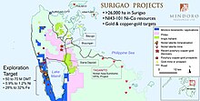
Nonoc Island has been identified as a special economic zone (Ecozone) by the national government, a boon older residents are quite familiar due to its once prosperous nickel ore production. This project is aimed to put the island's existing infrastructure, including a 1300-meter concrete airstrip and two 60,000 dwt seaport, back in operation. In 2005, China's Jinchuan Group Ltd. submitted a proposal to invest approximately US$1.0 billion for the rehabilitation and revival of the Nonoc nickel refinery. In 2010, Jinchuan renewed its interest in Nonoc, offering a bigger investment at $1.5 billion. However, its insistence for another feasibility study and disagreements over the operating structure shuttered the deal with Philnico who owns the mining rights for the island. In January 2012, San Miguel Corporation of the Philippines entered into a memorandum of agreement with the city government to rehabilitate and operate the Nonoc mines for $3 billion, the single biggest investment in the city yet.
The recent entry of major international mining company Sumitomo with $1.3 billion investment in the province sparked renewed interest of its vast mineral reserves and has helped spur secondary economic activities in the city. Other mining companies like Philex Mining Corporation, Mindoro Resources Ltd. and Anglo Ashanti are in various stages of exploration.
Local government[]
Surigao City is governed via the mayor-council system. The city council, nationally called Sangguniang Panlungsod, consists of the vice mayor and 12 council members. The mayor is elected directly every three years.
List of former city mayors[]
| Term | Name | hideNotes |
|---|---|---|
| 1970–1976 | Pedro R. Espina[25] | Served as mayor of the Municipality of Surigao from 1963 to 1970, and on August 31 1970, he was elected as the First Mayor of Surigao City. |
| 1976–1986 | Constantino Herrera Navarro Jr.[26] | Appointed as City Mayor in 1976 and elected as City Mayor in the 1980 Philippine Local Elections. His term ended with the change of Constitution. |
| 1986–1987 | Enrique Y. Tandan[27] | Appointed as acting Mayor during the transition period of national leadership from the deposed Pres. Ferdinand E. Marcos to Pres. Corazon C. Aquino in 1986. |
| 1988–1998 | Salvador C. Sering[28] | Elected in 1988 |
| 1998–1999 | Roland Arreza Sering[29] | Died in office |
| 1999–2010 | Alfonso Servaña Casurra[30] | Succeeded after the death of Roland Arreza Sering. Then elected to office. |
| 2010–2019 | Ernesto Tinio Matugas[31] | Term Ended in 2019 and ran for City Vice Mayor along with his son Estong running for City Mayor |
| 2019–present | Ernesto "Estong" U. Matugas Jr. |
Tourism[]
Tourism figures showed 200,000 foreign arrivals in the city in 2011, registering a 37% growth.[citation needed]
Annual events/festivals[]
- August 25–31 . Charter Day Celebrations. Weeklong festivities marked by a sportsfest, grand parade, evening gala affairs and the crowning of Mutya ng Surigao in commemoration of the city's founding (charter) on August 31, 1970.
- September 9 . Bonok- Bonok Maradjao Karadjao Festival. A day long parade marked by street dancing and festivities featuring the ethnic Mamanwa tribal dance, Bonok-bonok commemorating thanksgiving after a bountiful harvest, worship of gods and tribal wedding. Contingents from around the country showcase creative costumes, floats, dances and chants of Viva Señor San Nicolas! and Viva Maradjao Karajao! The dance rhythm starts with a slow beat as it pulsatingly goes faster, prompting snappy body movements to pace with the music. Colorful ceremonial costumes includes an elaborate beaded headdress or tubaw, bracelets and anklets. Prices are awarded to outstanding contingents in different categories at the culmination of the event held at the Surigao Provincial Sports Complex. The festival is held on the eve of the city's annual fiesta.
- September 10 . Surigao City fiesta.
- October 25 . Battle Of Surigao Strait. Held every October 25, in commemoration of the Last Great Battleship vs. Battleship Naval Battle of World War 2, highlighted by a pre-dawn memorial service, civil-military parade, and a memorial cruise along the Surigao Strait. Commemorating veterans, diplomats, consuls, and active naval personnel from the US, Australia, and Japan have been gracing the event over the past quarter century.
- December 26 . Commemoration of the First Hoisting of Philippine Flag in Mindanao. The Philippine flag in Mindanao was first raised in Surigao in the morning of December 26, 1898, at the Casa Real (town hall). The event was recorded in the diary of Fr. Alberto Masoliver, now kept in the Jesuit Archives in Spain [5].
Infrastructure[]


Surigao Provincial Sports Complex
Host to numerous national and regional events, the complex underwent renovation in 2009 at a cost of Php320 million. It is situated on the 2-hectare Vasquez field and includes a 3,500-person capacity grandstand, a fully air conditioned 3,500 seating capacity gymnasium, a brand new amphitheater, an Olympic-size swimming pool (renovated in 2020) and a fully rubberized track and field oval. Surigao Provincial Convention Center, also part of the complex, has a seating capacity of approximately 2,500 persons.[32]
| Wikimedia Commons has media related to Surigao Provincial Sports Complex. |
Waste Management Facility Averaging a 21-ton daily collected garbage, the local government of Surigao built a sanitary landfill in Sitio Looc in 2009 under a PP150 million grant from the Swedish government and assistance from the Land Bank of the Philippines. It is considered a model for solid waste management which includes a P45 million-worth waste treatment facility, a material recovery facility which treats recyclables and a leachate collector, which extracts and treats liquids from garbage.
Transportation[]
Motorized tricycles, an indigenous form of auto- rickshaw that can accommodate about six passengers, is mainly the mode of transport in the city. Buses and jeepneys follow fixed routes to outlying barangays, towns and neighboring provinces. The city is also served by outrigger water taxis called pump boats that follow scheduled sea routes to island barangays. Larger vessels called Lantsa have scheduled trips to Siargao, Dinagat and Bucas Grande. Regular ferry service connects the city to ports in Southern Leyte, Cebu, Manila and Agusan del Norte. There are direct flights to Manila and Cebu originating from the city's airport with occasional chartered flights to Siargao, Butuan and Tandag.

Historic Verano port completed a PP414 expansion and upgrade in 2009 to meet world standards and increased cargo demand from a revitalized mining industry in the province. Additional 2000 square meters of reclaimed area and 120 meters of berthing space were added. The port ranks as a major transshipment point in region.
Lipata Port and Ferry Terminal serves as the entry point to Mindanao Island forming part of the extensive Pan-Philippine Highway also called Maharlika Highway AH26 that originates from Laoag to its southern terminus in Zamboanga City. The port has ro-ro capabilities that provides regular service to the ports of Liloan and San Ricardo, both in Southern Leyte.
The northernmost terminus in Mindanao of the Pan-Philippine Highway (AH26) is in Surigao City, dissecting the Surigao Valley before the Surigao-Davao Coastal Road spurs at Bad-as, Placer. An integrated Land Transport Terminal serves companies with routes that reach major destinations including Ormoc, Tacloban, Legazpi, Manila, Butuan (change buses travel to Cagayan de Oro), Tandag, Davao, and Bislig (Mangagoy). Bus companies serving this terminal includes Bachelor Express, Philtranco, Davao Metro Shuttle, PP Bus Line and Surigao Express.
Completed in 2007, San Juan-Lipata Coastal Road connects the Port of Lipata to downtown Surigao, cutting the travel time in half. It includes a series of bridges across coastal barangays of San Juan and Sabang. The longest, Banahaw, spans the Surigao tidal basin.

Classified by the Civil Aviation Authority of the Philippines as a principal domestic airport, Surigao Airport (SUG) is one of the two airports that serve the province of Surigao del Norte and northern parts of Surigao del Sur and Agusan del Norte. Cebgo and Airphil Express have regular scheduled flights from Surigao to Manila and Cebu. Small private planes operate chartered flights to Siargao's Sayak Airport. Due to increased passenger traffic and cargo, it is undergoing feasibility studies for future expansion to accommodate larger aircraft.
Telecommunications[]
New facilities built by leading telecommunication companies paved way for clear reception to other parts of the country and the rest of the world. The PLDT (formerly PhilCom), Bayan Telecommunications (Bayantel), Sun Cellular, Globe Telecom and Smart Communications (formerly Cruztelco) operate vital transmission towers in the city.
Healthcare[]
On February 11, 1997, the Congress of the Philippines enacted Republic Act 8244 converting Surigao Provincial Hospital into a regional training hospital and renamed it Caraga Regional Hospital[6], effectively expanding its scope and services that would include the entire Caraga region with a catchment population of nearly 2 million people. Today, this 150- bed tertiary hospital, a core referral facility, is rapidly expanding with intensive care units that includes Coronary, Pediatric, Surgical and Burn.
In October 2010, the city opened a PP35 million Drug Rehabilitation and Treatment Center in Anomar. Established under the aegis of the Department of Health, it is the first and only facility in the entire Caraga region solely focused on the treatment and rehabilitation of victims of substance abuse.
Other major hospitals in the city include St. Paul University Hospital, Miranda Family Hospital, Surigao Medical Center (undergoing a major expansion) & the soon to open Surigao Doctors Hospital.
Education[]
Surigao traces its roots to formal schooling in the year 1906 when the last group of Spanish Benedictine Missionaries, who had worked zealously to have founded the Cartilla or Doctrina School (Escuela Catolica de San Nicolas), vacated Surigao. Soon after their departure, the Missionaries of the Sacred Heart also known as the Dutch Fathers, succeeded them, created the parish of Surigao, and made the Escuela Catolica de San Nicolas a parochial school which later became San Nicolas College. In 2002, Surigao became the first urban center in the entire Caraga region to host a university after San Nicolas College changed its nomenclature in 2004 to Saint Paul University Surigao[7], a part of Saint Paul University System.
In 1969, Surigao School of Arts and Trades was established on 1.2 hectares of land donated by the provincial government. It focused on curricula geared towards technology at a time the city saw rapid transformation with the onset of nickel exploration at the Nonoc island refinery. While the school was built, it initially held classes at the Provincial Sports Complex with a core census of 14 teachers and 103 students. In 1998, the school was renamed Surigao State College of Technology after it merged with Malimono School of Fisheries. On June 4, 2013, Surigao del Norte State University [8] was established under Rep. Act 10600, integrating Surigao del Norte State College of Technology with Siargao National College of Science and Technology in Del Carmen and the Surigao del Norte College of Agriculture and Technology in Mainit. The name change is still yet to be implemented after it was amended by RA 11010 that the institution shall retain its status prior to the effectivity of this Act until it is able to comply with CHED requirements.
San Sebastian College - Recoletos College of Law - Surigao City Extension located in Taft opened in 1997. Other colleges in the city include Surigao Education Center [9], St. Jude Thaddeus Institute of Technology, STI College Surigao [10], Northeastern Mindanao Colleges, St Ignatius Loyola Computer College, and the newly established Surigao Doctor's College (formerly the Center for Healthcare Professions - Surigao).
In 1996, Caraga Regional Science High School was established in San Juan, providing students in the entire region an opportunity to join an academe of reputable standards, now nationally recognized. Students undergo a rigorous highly accelerated 4- level curriculum which includes two years of general studies and two years of a chosen major. With much success as it garnered consistent topnotchers in the National Secondary Achievement Test (NSAT), students also have opportunities to carry out independent research and compete in Intel Science Fairs.
Media[]
AM Stations
FM Stations
- Infinite Radio 93.3
- Joy FM 94.9
- One FM 96.1
- DABIG C FM 100.5 (formerly Prime FM)
- Real Radio 104.7
- DXMS 107.3 All Star FM ng Masa
Television
- GMA Channel 10
- ABS-CBN Channel 12
- TV5 Channel 19 (soon)
- S+A Channel 23
- GTV Channel 27
Cable companies
- Surigao Cable TV (SCATV)
- Cignal
Sister cities[]
Local[]
 Cagayan de Oro
International[]
 Hialeah, Florida, United States
 Seoul, South Korea
References[]
- ^ City of Surigao | (DILG)
- ^ "2015 Census of Population, Report No. 3 – Population, Land Area, and Population Density" (PDF). Philippine Statistics Authority. Quezon City, Philippines. August 2016. ISSN 0117-1453. Archived (PDF) from the original on May 25, 2021. Retrieved July 16, 2021.
- ^ Jump up to: a b Census of Population (2020). "Caraga". Total Population by Province, City, Municipality and Barangay. PSA. Retrieved 8 July 2021.
- ^ https://psa.gov.ph/sites/default/files/City%20and%20Municipal-level%20Small%20Area%20Poverty%20Estimates_%202009%2C%202012%20and%202015_0.xlsx; publication date: 10 July 2019; publisher: Philippine Statistics Authority.
- ^ Philippine Institute of Traditional and Alternative Health Care, Department of Health; University of the Philippines Manila; University of the Philippines Mindanao (2000). "Ethnomedical documentation of and community health education for selected Philippine ethnolinguistic groups: the Mandaya people of Davao Oriental, Philippines" (PDF). Retrieved 2015-04-22.[permanent dead link]
- ^ Benito Francia y Ponce de Leon; Julián González Parrado (1898). La Islas Filipinas. Mindanao, Volume 1. Subinspección de Infantería. p. 197.
- ^ Pio A. De Pazos y Vela-Hidalgo (ed.). Jolo, Relato Historico-Militar: Desde Su Descubrimiento Por Los Espanoles en 1578 A Nuestros Dias (1879). Imprenta y Estereotipia de Polo.
- ^ Paredes, Francis Tom; Paredes, Sheila (2017). The Monosyllabic root -ao in Mindanao Languages. 8th Annual In-house Review of the Research Office of Agusan del Sur State College of Agriculture and Technology. Agusan del Sur State College of Agriculture and Technology.
- ^ Virginia Holmes, Guerrilla Daughter (Kent, Ohio: Kent State U. Press, 2009), p. 169.
- ^ Holmes, p. 169.
- ^ "An Act Converting into Barrios Certain Sitios in the Province of Surigao, and Dividing the Barrio of Macalaya into Two Barrios, Municipality of Placer, in the Same Province". LawPH.com. Archived from the original on 2012-07-11. Retrieved 2011-04-12.
- ^ "An Act to Create the Provinces of Surigao del Norte and Surigao del Sur". LawPH.com. Retrieved 2011-04-12.
- ^ "Surigao del Norte Climatological Normal Values". Philippine Atmospheric, Geophysical and Astronomical Services Administration. Archived from the original on 18 October 2018. Retrieved 18 October 2018.
- ^ "Surigao del Norte Climatological Extremes". Philippine Atmospheric, Geophysical and Astronomical Services Administration. Archived from the original on 18 October 2018. Retrieved 18 October 2018.
- ^ Census of Population (2015). "Caraga". Total Population by Province, City, Municipality and Barangay. PSA. Retrieved 20 June 2016.
- ^ Census of Population and Housing (2010). "Caraga". Total Population by Province, City, Municipality and Barangay. NSO. Retrieved 29 June 2016.
- ^ Censuses of Population (1903–2007). "Caraga". Table 1. Population Enumerated in Various Censuses by Province/Highly Urbanized City: 1903 to 2007. NSO.
- ^ "Province of Surigao del Norte". Municipality Population Data. Local Water Utilities Administration Research Division. Retrieved 17 December 2016.
- ^ "Poverty incidence (PI):". Philippine Statistics Authority. Retrieved 28 December 2020.
- ^ https://psa.gov.ph/sites/default/files/NSCB_LocalPovertyPhilippines_0.pdf; publication date: 29 November 2005; publisher: Philippine Statistics Authority.
- ^ https://psa.gov.ph/sites/default/files/2003%20SAE%20of%20poverty%20%28Full%20Report%29_1.pdf; publication date: 23 March 2009; publisher: Philippine Statistics Authority.
- ^ https://psa.gov.ph/sites/default/files/2006%20and%202009%20City%20and%20Municipal%20Level%20Poverty%20Estimates_0_1.pdf; publication date: 3 August 2012; publisher: Philippine Statistics Authority.
- ^ https://psa.gov.ph/sites/default/files/2012%20Municipal%20and%20City%20Level%20Poverty%20Estima7tes%20Publication%20%281%29.pdf; publication date: 31 May 2016; publisher: Philippine Statistics Authority.
- ^ https://psa.gov.ph/sites/default/files/City%20and%20Municipal-level%20Small%20Area%20Poverty%20Estimates_%202009%2C%202012%20and%202015_0.xlsx; publication date: 10 July 2019; publisher: Philippine Statistics Authority.
- ^ RPN (2020-09-01). "Pedro R. Espina, The First Mayor Of Surigao City". Radio Philippines Network (RPN). Retrieved 2021-09-04.
- ^ RPN (2020-09-01). "Constantino Herrera Navarro Jr., Second Mayor Of Surigao City (1976-1986)". Radio Philippines Network (RPN). Retrieved 2021-09-04.
- ^ RPN (2020-09-01). "Atty. Enrique Y. Tandan, Third Mayor Of Surigao City (1986-1987)". Radio Philippines Network (RPN). Retrieved 2021-09-04.
- ^ RPN (2020-09-01). "Atty. Salvador C. Sering, Fourth Mayor Of Surigao City (1988-1998)". Radio Philippines Network (RPN). Retrieved 2021-09-04.
- ^ RPN (2020-09-01). "Roland Arreza Sering, Fifth Mayor Of Surigao City (1998-1999)". Radio Philippines Network (RPN). Retrieved 2021-09-04.
- ^ RPN (2020-09-01). "Atty. Alfonso Servaña Casurra, Sixth Mayor Of Surigao City (1999-2010)". Radio Philippines Network (RPN). Retrieved 2021-09-04.
- ^ RPN (2020-09-01). "Engr. Ernesto Tinio Matugas, Seventh Mayor Of Surigao City (2010-2019)". Radio Philippines Network (RPN). Retrieved 2021-09-04.
- ^ "Modern sports complex re-opens in Surigao". ABS-CBN News. Retrieved 17 January 2020.
External links[]
| Wikivoyage has a travel guide for Surigao City. |
| Wikimedia Commons has media related to Surigao City. |
- Official website
- Philippine Standard Geographic Code
- Philippine Census Information
- Local Governance Performance Management System
| show Places adjacent to Surigao City |
|---|
| show Articles Related to Surigao |
|---|

| show Authority control |
|---|
- Surigao City
- Cities in Caraga
- Provincial capitals of the Philippines
- Populated places in Surigao del Norte
- Port cities and towns in the Philippines
- Populated places established in 1655
- 1655 establishments in the Philippines
- Mining communities in the Philippines
- Component cities in the Philippines