Taillebourg, Charente-Maritime
Taillebourg | |
|---|---|
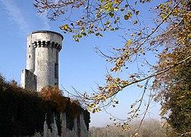 Chateau | |
 Coat of arms | |
show Location of Taillebourg | |
 Taillebourg | |
| Coordinates: 45°50′15″N 0°38′32″W / 45.8375°N 0.6422°WCoordinates: 45°50′15″N 0°38′32″W / 45.8375°N 0.6422°W | |
| Country | France |
| Region | Nouvelle-Aquitaine |
| Department | Charente-Maritime |
| Arrondissement | Saint-Jean-d'Angély |
| Canton | Saint-Jean-d'Angély |
| Government | |
| • Mayor (2020–2026) | Pierre Texier |
| Area 1 | 14.25 km2 (5.50 sq mi) |
| Population (Jan. 2018)[1] | 743 |
| • Density | 52/km2 (140/sq mi) |
| Time zone | UTC+01:00 (CET) |
| • Summer (DST) | UTC+02:00 (CEST) |
| INSEE/Postal code | 17436 /17350 |
| Elevation | 2–63 m (6.6–206.7 ft) |
| 1 French Land Register data, which excludes lakes, ponds, glaciers > 1 km2 (0.386 sq mi or 247 acres) and river estuaries. | |


Taillebourg (French pronunciation: [tajbuʁ]) is a commune in the Charente-Maritime department in southwestern France.
It is built on a rock, overlooking the Charente River, 9 km downstream from Saintes.
The place is first mentioned as terra Talleburgi in 1267
It was the site of three battles that bear its name: Battle of Taillebourg, on account of its strategically important position as a river crossing. There was also a fourth action, a siege.
The château dominates the town and was the garrison of Louis IX (known as 'Saint Louis'), before the eponymous 1242 battle.
The ancient bridge over the Charente has since been destroyed but there is a long causeway, which spans the surrounding marshes and serves to keep the road open, even during times of flooding.
Population[]
| Year | Pop. | ±% |
|---|---|---|
| 1962 | 636 | — |
| 1968 | 681 | +7.1% |
| 1975 | 637 | −6.5% |
| 1982 | 626 | −1.7% |
| 1990 | 561 | −10.4% |
| 1999 | 600 | +7.0% |
| 2008 | 732 | +22.0% |
See also[]
References[]
- ^ "Populations légales 2018". INSEE. 28 December 2020.
External links[]
| Wikimedia Commons has media related to Taillebourg (Charente-Maritime). |
This Charente-Maritime geographical article is a stub. You can help Wikipedia by . |
- Communes of Charente-Maritime
- Charente-Maritime geography stubs