Vaux-le-Moncelot
Vaux-le-Moncelot | |
|---|---|
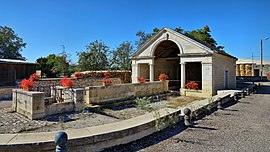 The wash house and fountain in Vaux-le-Moncelot | |
show Location of Vaux-le-Moncelot | |
 Vaux-le-Moncelot | |
| Coordinates: 47°28′24″N 5°54′08″E / 47.4733°N 5.9022°ECoordinates: 47°28′24″N 5°54′08″E / 47.4733°N 5.9022°E | |
| Country | France |
| Region | Bourgogne-Franche-Comté |
| Department | Haute-Saône |
| Arrondissement | Vesoul |
| Canton | Scey-sur-Saône-et-Saint-Albin |
| Area 1 | 7.04 km2 (2.72 sq mi) |
| Population (Jan. 2018)[1] | 72 |
| • Density | 10/km2 (26/sq mi) |
| Demonym(s) |
|
| Time zone | UTC+01:00 (CET) |
| • Summer (DST) | UTC+02:00 (CEST) |
| INSEE/Postal code | 70527 /70700 |
| Elevation | 224–300 m (735–984 ft) |
| 1 French Land Register data, which excludes lakes, ponds, glaciers > 1 km2 (0.386 sq mi or 247 acres) and river estuaries. | |


Vaux-le-Moncelot is a commune in the Haute-Saône department in the region of Bourgogne-Franche-Comté in eastern France.
Its inhabitants are the Vauxlemonçois.[3]
Geography[]
Vaux-le-Moncelot includes a communal forest, with an area of 80 hectares, made up of 77% of pedunculate oaks, 14% of hornbeam, 7% of ash trees, less than 3% of other hardwoods and douglas. It is operated by the National Forestry Office.[4] The town is crossed to the west by the Jouanne stream.
Bordering municipalities[]

Town planning[]
Typology[]
Vaux-le-Moncelot is a rural municipality, because it is part of the municipalities with little or very little density, within the meaning of the municipal density grid of INSEE.[5][6][7]
In addition, the municipality is part of the attraction area of Besançon, of which it is a municipality in the crown. This area, which includes 312 municipalities, is categorized in areas of 200,000 to less than 700,000 inhabitants.[8][9]
Land use[]
The zoning of the municipality, as reflected in the database European occupation biophysical soil Corine Land Cover (CLC), is marked by the importance of the agricultural land (77.3% in 2018) , nevertheless down compared to 1990 (79.2%). The detailed breakdown in 2018 is as follows:[10]
- arable land (38.7%)
- meadows (38.4%)
- forests (17.4%)
- areas with shrub and/or herbaceous vegetation (2.9%)
- areas urbanized (2.5%)
- heterogeneous agricultural areas (0.2%).
The IGN also provides an online tool to compare the evolution over time of land use in the municipality (or in territories at different scales). Several eras are accessible as aerial maps or photos: the Cassini map (18th century), the map of Staff (1820-1866) and the current period (1950 to present).[11]
Politics and administration[]
Administrative and electoral attachments[]
The town is part of the district of Vesoul in the department of Haute-Saône, in the Bourgogne-Franche-Comté region. For the election of deputies, it depends on the first constituency of Haute-Saône.
Since 1793 it was part of the canton of Gy.[12] As part of the 2014 cantonal redistribution in France, the town is now integrated into the canton of Scey-sur-Saône-et-Saint-Albin
Intercommunality[]
Vaux-le-Moncelot has been a member since 2007 of the community of municipalities of Monts de Gy, a public establishment of inter-municipal cooperation (EPCI) with its own taxation created at the end of 1999 and to which the municipality has transferred a certain number of its powers, under the conditions determined by the general code of local authorities.
| Elected in | Identity |
|---|---|
| 2001 | Jean-Marie Colin |
| 2008 | Claudine Narçon |
| 2014 | Roland Baulay |
Demography[]
The evolution of the number of inhabitants is known through the population censuses carried out in the municipality since 1793. From 2006, the legal populations of the municipalities are published annually by Insee. The census is now based on an annual collection of information, successively concerning all the municipal territories over a period of five years. For municipalities with less than 10,000 inhabitants, a census survey covering the entire population is carried out every five years, the legal populations of the intervening years being estimated by interpolation or extrapolation.[14] For the municipality, the first exhaustive census falling under the new system was carried out in 2005.[15]
In 2018, the town had 72 inhabitants, down 6.49% compared to 2013.
Local culture and heritage[]
Places and monuments[]
Fontaine-lavoir built in 1861 to plans by the Grayl architect Christophe Colard.
Heraldry[]
 |
Coat of arms | Cut Azure at the fountain of the place of silver accompanied by eight gold billets, four dextral and four sinister, ordered 2, 1 and 1 , those in the middle rows in a dexter bar and in a sinister band with a of the leader and that of peak; and Or with a vaulted chevron Gules interlaced with a bent chevron reversed of the same, each charged with two ears of wheat stalked and curved Or, the rafters accompanied by three cakes Gules arranged in fess, that of the middle enclosed in the rafters.[3] |
|---|---|---|
| Details | Coat of arms composed by Mr. Nicolas Vernot, adopted by the municipality on July 29, 2015. |
See also[]
References[]
- ^ "Populations légales 2018". INSEE. 28 December 2020.
- ^ "Insolite - Les habitants de Vaux-le-Moncelot n'avaient ni blason, ni gentilé. C'est désormais chose faite…. Haute-Saône : Appelez-les les «Vaulemonçois» !". www.estrepublicain.fr (in French). Retrieved 2021-06-30.
- ^ Jump up to: a b "Insolite - Les habitants de Vaux-le-Moncelot n'avaient ni blason, ni gentilé. C'est désormais chose faite…. Haute-Saône : Appelez-les les «Vaulemonçois» !". www.estrepublicain.fr (in French). Retrieved 2021-06-30.
- ^ "Vaux-le-Moncelot. La forêt sous contrat ONF pour les 20 ans à venir". www.estrepublicain.fr (in French). Retrieved 2021-06-30.
- ^ "Typologie urbain / rural | L'Observatoire des Territoires". www.observatoire-des-territoires.gouv.fr. Retrieved 2021-06-30.
- ^ "Définition - Commune rurale | Insee". www.insee.fr. Retrieved 2021-06-30.
- ^ "Comprendre la grille de densité | L'Observatoire des Territoires". www.observatoire-des-territoires.gouv.fr. Retrieved 2021-06-30.
- ^ "Aire d'attraction des villes 2020 de Besançon (045) − COG | Insee". www.insee.fr. Retrieved 2021-06-30.
- ^ "En France, neuf personnes sur dix vivent dans l'aire d'attraction d'une ville - Insee Focus - 211". www.insee.fr. Retrieved 2021-06-30.
- ^ "CORINE Land Cover | Données et études statistiques". archive.wikiwix.com. Archived from the original on 2019-03-21. Retrieved 2021-06-30.
- ^ "Remonter le temps". remonterletemps.ign.fr. Retrieved 2021-06-30.
- ^ "Vaux-le-Moncelot - Notice Communale". cassini.ehess.fr. Retrieved 2021-06-30.
- ^ "Les anciens maires de la commune de Vaux-le-Moncelot - Mairie de Vaux-le-Moncelot et son village". www.annuaire-mairie.fr. Retrieved 2021-06-30.
- ^ "Présentation du recensement de la population | Insee". www.insee.fr. Retrieved 2021-06-30.
- ^ "Documentation complémentaire sur le recensement | Insee". www.insee.fr. Retrieved 2021-06-30.
| Wikimedia Commons has media related to Vaux-le-Moncelot. |
This Haute-Saône geographical article is a stub. You can help Wikipedia by . |
- Communes of Haute-Saône
- Haute-Saône geography stubs