Yviers
show This article may be expanded with text translated from the corresponding article in French. (June 2019) Click [show] for important translation instructions. |
Yviers | |
|---|---|
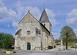 The church in Yviers | |
show Location of Yviers | |
 Yviers | |
| Coordinates: 45°16′33″N 0°00′13″W / 45.2758°N 0.0036°WCoordinates: 45°16′33″N 0°00′13″W / 45.2758°N 0.0036°W | |
| Country | France |
| Region | Nouvelle-Aquitaine |
| Department | Charente |
| Arrondissement | Angoulême |
| Canton | Tude-et-Lavalette |
| Intercommunality | |
| Government | |
| • Mayor (2014-2020) | Jean-Claude Lafaye |
| Area 1 | 22.56 km2 (8.71 sq mi) |
| Population (Jan. 2018)[1] | 518 |
| • Density | 23/km2 (59/sq mi) |
| Time zone | UTC+01:00 (CET) |
| • Summer (DST) | UTC+02:00 (CEST) |
| INSEE/Postal code | 16424 /16210 |
| Elevation | 48–147 m (157–482 ft) (avg. 52 m or 171 ft) |
| 1 French Land Register data, which excludes lakes, ponds, glaciers > 1 km2 (0.386 sq mi or 247 acres) and river estuaries. | |


Yviers is a commune in the Charente department in southwestern France.
Population[]
| Year | Pop. | ±% |
|---|---|---|
| 2005 | 487 | — |
| 2006 | 491 | +0.8% |
| 2007 | 493 | +0.4% |
| 2008 | 501 | +1.6% |
| 2009 | 508 | +1.4% |
| 2010 | 516 | +1.6% |
| 2011 | 520 | +0.8% |
| 2012 | 509 | −2.1% |
| 2013 | 508 | −0.2% |
| 2014 | 508 | +0.0% |
| 2015 | 507 | −0.2% |
| 2016 | 511 | +0.8% |
Politics[]
Presidential Elections 2nd Round [2][]
| Election | Winning Candidate | Party | % | |
|---|---|---|---|---|
| 2017 | Marine Le Pen | FN | 50.65 | |
| 2012 | François Hollande | PS | 54.14 | |
| 2007 | Nicolas Sarkozy | UMP | 54.68 | |
| 2002 | Jacques Chirac | RPR | 82.08 | |
See also[]
References[]
- ^ "Populations légales 2018". INSEE. 28 December 2020.
- ^ http://www.lemonde.fr/data/france/presidentielle-2017/
| Wikimedia Commons has media related to Yviers. |
This Charente geographical article is a stub. You can help Wikipedia by . |
Categories:
- Communes of Charente
- Charente geography stubs