İmranlı
İmranlı | |
|---|---|
 İmranlı | |
| Coordinates: 39°52′48″N 38°7′58″E / 39.88000°N 38.13278°ECoordinates: 39°52′48″N 38°7′58″E / 39.88000°N 38.13278°E | |
| Country | Turkey |
| Province | Sivas |
| Government | |
| • Kaymakam | Hüseyin ÇAMKERTEN |
| Area | |
| • District | 1,217.47 km2 (470.07 sq mi) |
| Elevation | 1,650 m (5,410 ft) |
| Population (2012)[2] | |
| • Urban | 3,587 |
| • District | 7,882 |
| • District density | 6.5/km2 (17/sq mi) |

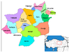
İmranlı (Kurdish: Macîran),[3] is a town and a district of Sivas Province of Turkey. Population is 6,600 (2005 census). The mayor was Murat Açıl (CHP). The town is located at 108 km to Sivas. It became a district on January 1, 1948, while it was a part of the Zara district.
Demographics
The town is populated by Sunni Turks and Kurdish Alevis. 65 villages in the district are populated by Kurdish Alevis.[4]
Population
The population of İmranlı district slowly increased to a maximum of 32,253 people between 1950 and 1965. In the 1970s there was a high level of emigration: people left the district because of the lack of social capacities and economic investment, especially towards Western Europe and larger cities in Turkey. Since 2007, the population of the district has been relatively stable, fluctuating between 7,200 and 7,700 inhabitants. The population development of the district is shown in the graph below.[5][6][7][8][9][10][11][12][13]

Settlements
İmranlı districts consists of the only town İmranlı and 102 small villages.
|
|
|
|
|
|
References
- ^ "Area of regions (including lakes), km²". Regional Statistics Database. Turkish Statistical Institute. 2002. Retrieved 2013-03-05.
- ^ "Population of province/district centers and towns/villages by districts - 2012". Address Based Population Registration System (ABPRS) Database. Turkish Statistical Institute. Retrieved 2013-02-27.
- ^ Adem Avcıkıran (2009). Kürtçe Anamnez Anamneza bi Kurmancî (PDF) (in Turkish and Kurdish). p. 57. Retrieved 17 December 2019.
- ^ Peter Alfred, Andrews; Benninghaus, Rüdiger, eds. (1989). Ethnic Groups in the Republic of Turkey. pp. 345–346.
- ^ Census 1940
- ^ Census 1950
- ^ Census 1955
- ^ Census 1960
- ^ Census 1970
- ^ Census 1975
- ^ Census 1980
- ^ Census 1985
- ^ Census 1990
This geographical article about a location in Sivas Province, Turkey is a stub. You can help Wikipedia by . |
- Populated places in Sivas Province
- Districts of Sivas Province
- Kurdish settlements in Turkey
- Central Anatolia Region geography stubs