Agno, Pangasinan
Agno | |
|---|---|
| Municipality of Agno | |
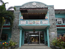 Presidencia Agno Pangasinan | |
 Seal | |
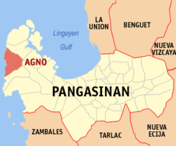 Map of Pangasinan with Agno highlighted | |
show OpenStreetMap | |
 Agno Location within the Philippines | |
| Coordinates: 16°06′58″N 119°48′10″E / 16.116086°N 119.802683°ECoordinates: 16°06′58″N 119°48′10″E / 16.116086°N 119.802683°E | |
| Country | Philippines |
| Region | Ilocos Region |
| Province | Pangasinan |
| District | 1st district |
| Founded | November 25, 1791 [1] |
| Barangays | 17 (see Barangays) |
| Government | |
| • Type | Sangguniang Bayan |
| • Mayor | Gualberto R. Sison |
| • Vice Mayor | Jose N. Pajeta Jr. |
| • Representative | Arnold D. Celeste |
| • Municipal Council | show
Members |
| • Electorate | 19,087 voters (2019) |
| Area | |
| • Total | 169.75 km2 (65.54 sq mi) |
| Elevation | 43 m (141 ft) |
| Highest elevation | 140 m (460 ft) |
| Lowest elevation | 0 m (0 ft) |
| Population (2020 census) [4] | |
| • Total | 29,947 |
| • Density | 180/km2 (460/sq mi) |
| • Households | 6,593 |
| Economy | |
| • Income class | 3rd municipal income class |
| • Poverty incidence | 16.61% (2015)[5] |
| • Revenue | ₱90,745,106.82 (2016) |
| Service provider | |
| • Electricity | Pangasinan 1 Electric Cooperative (PANELCO 1) |
| Time zone | UTC+8 (PST) |
| ZIP code | 2408 |
| PSGC | |
| IDD : area code | +63 (0)75 |
| Climate type | tropical monsoon climate |
| Native languages | Pangasinan Ilocano Tagalog |
| Website | www |


Agno, officially the Municipality of Agno (Pangasinan: Baley na Agno; Ilocano: Ili ti Agno; Tagalog: Bayan ng Agno), is a 3rd class municipality in the province of Pangasinan, Philippines. According to the 2020 census, it has a population of 29,947 people. [4]
The town is characterized by rolling terrain and rainfed rice fields. Near the poblacion, or town plaza, the road passes along the Mabini river or (Balincaguing River), which drains into the South China Sea further west. The town plaza is home to a centuries-old Roman Catholic church, as well as one of the first congregations of the Philippine Independent Church. The town shares borders with the town of Bani to the north, the town of Mabini and Alaminos City to the east and with Burgos to the south. Contrary to popular belief, the Agno River do not pass this municipality.
The town's main livelihood is fishing and agriculture, although a number of her sons and daughters work as doctors, physical therapist, nurses, engineers, computer programmers and accountants in numerous countries around the globe. On top of that, the town produces successful teachers, policemen and policewomen, and lawyers.
During the summer months of April and May the town's market abounds with fresh fruits such as mangoes and duhat, as well as fresh catch such as tuna, flying fish, grouper, lobsters and other seafood.
The town is home to natural attractions such as the Mabini river, the Umbrella Rocks in Sabangan, as well as several beaches, Agno Beach being the longest and most popular. There are several other beaches hidden along the coast such as the Macaboboni cove (which features a small cave) as well as a white beach in Barangay Gayusan. To the southern end of Agno Beach, one can dive from a two-story-high rock amidst crashing waves and end up in a beautiful coral garden below.
Arthur Cabantac was the mayor of Agno from 2007 until he was shot in 2008 while playing Mahjong.[6] He was then succeeded by Jose N. Pajeta Jr, the town's vice mayor during that time.
History[]
The name Agno was derived from a species of swamp tree called “Agno Casto”, a chaste tree used for medicinal concoctions to relieve pain and illness, that grew abundantly in the locality. In time, “Agno” was retained to become the name of the town.
Agno was formally organized into municipality in 1791. During the Spanish regime and early part of the American era, Agno was part of the Province of Zambales, but upon enactment of Public Act No. 1004 dated November 30, 1903, of the Philippine Commission, the northern part of Zambales including Agno was annexed to the Province of Pangasinan.
Barangays[]
Agno is politically subdivided into 17 barangays.[7]
- Allabon
- Aloleng
- Bangan Oda
- Baruan
- Boboy
- Cayungnan
- Dangley
- Gayusan
- Macaboboni
- Magsaysay
- Namatucan
- Patar
- Poblacion East
- Poblacion West
- San Juan
- Tupa
- Viga
Climate[]
| hideClimate data for Agno, Pangasinan | |||||||||||||
|---|---|---|---|---|---|---|---|---|---|---|---|---|---|
| Month | Jan | Feb | Mar | Apr | May | Jun | Jul | Aug | Sep | Oct | Nov | Dec | Year |
| Average high °C (°F) | 31 (88) |
31 (88) |
32 (90) |
34 (93) |
35 (95) |
34 (93) |
32 (90) |
32 (90) |
32 (90) |
32 (90) |
32 (90) |
31 (88) |
32 (90) |
| Average low °C (°F) | 22 (72) |
22 (72) |
22 (72) |
24 (75) |
24 (75) |
24 (75) |
24 (75) |
24 (75) |
24 (75) |
23 (73) |
23 (73) |
22 (72) |
23 (74) |
| Average precipitation mm (inches) | 13.6 (0.54) |
10.4 (0.41) |
18.2 (0.72) |
15.7 (0.62) |
178.4 (7.02) |
227.9 (8.97) |
368.0 (14.49) |
306.6 (12.07) |
310.6 (12.23) |
215.7 (8.49) |
70.3 (2.77) |
31.1 (1.22) |
1,766.5 (69.55) |
| Average rainy days | 3 | 2 | 2 | 4 | 14 | 16 | 23 | 21 | 24 | 15 | 10 | 6 | 140 |
| Source: World Weather Online[8] | |||||||||||||
Demographics[]
| Year | Pop. | ±% p.a. |
|---|---|---|
| 1903 | 6,169 | — |
| 1918 | 7,536 | +1.34% |
| 1939 | 9,533 | +1.13% |
| 1948 | 12,485 | +3.04% |
| 1960 | 13,424 | +0.61% |
| 1970 | 15,216 | +1.26% |
| 1975 | 16,011 | +1.03% |
| 1980 | 17,241 | +1.49% |
| 1990 | 21,197 | +2.09% |
| 1995 | 23,326 | +1.81% |
| 2000 | 25,077 | +1.56% |
| 2007 | 26,023 | +0.51% |
| 2010 | 27,508 | +2.04% |
| 2015 | 28,052 | +0.37% |
| 2020 | 29,947 | +1.29% |
| Source: Philippine Statistics Authority [9] [10] [11][12] | ||
Economy[]
| Poverty Incidence of Agno | |
| Source: Philippine Statistics Authority[13][14][15][16][17][18] | |
Heritage[]
References[]
- ^ https://www.flickr.com/groups/474900@N22/discuss/72157601652798206/
- ^ Municipality of Agno | (DILG)
- ^ "2015 Census of Population, Report No. 3 – Population, Land Area, and Population Density" (PDF). Philippine Statistics Authority. Quezon City, Philippines. August 2016. ISSN 0117-1453. Archived (PDF) from the original on May 25, 2021. Retrieved July 16, 2021.
- ^ Jump up to: a b Census of Population (2020). "Region I (Ilocos Region)". Total Population by Province, City, Municipality and Barangay. PSA. Retrieved 8 July 2021.
- ^ https://psa.gov.ph/sites/default/files/City%20and%20Municipal-level%20Small%20Area%20Poverty%20Estimates_%202009%2C%202012%20and%202015_0.xlsx; publication date: 10 July 2019; publisher: Philippine Statistics Authority.
- ^ "(UPDATE) Mayor of Agno, Pangasinan shot dead – report". ABS-CBN News. 2008-08-03. Archived from the original on 2012-07-18. Retrieved 2008-08-09.
- ^ "Province: PANGASINAN". PSGC Interactive. Makati, Philippines: National Statistical Coordination Board. Archived from the original on 14 November 2012. Retrieved 26 November 2012.
- ^ "Agno, Pangasinan: Average Temperatures and Rainfall". World Weather Online. Retrieved 23 September 2015.
- ^ Census of Population (2015). "Region I (Ilocos Region)". Total Population by Province, City, Municipality and Barangay. PSA. Retrieved 20 June 2016.
- ^ Census of Population and Housing (2010). "Region I (Ilocos Region)". Total Population by Province, City, Municipality and Barangay. NSO. Retrieved 29 June 2016.
- ^ Censuses of Population (1903–2007). "Region I (Ilocos Region)". Table 1. Population Enumerated in Various Censuses by Province/Highly Urbanized City: 1903 to 2007. NSO.
- ^ "Province of Pangasinan". Municipality Population Data. Local Water Utilities Administration Research Division. Retrieved 17 December 2016.
- ^ "Poverty incidence (PI):". Philippine Statistics Authority. Retrieved 28 December 2020.
- ^ https://psa.gov.ph/sites/default/files/NSCB_LocalPovertyPhilippines_0.pdf; publication date: 29 November 2005; publisher: Philippine Statistics Authority.
- ^ https://psa.gov.ph/sites/default/files/2003%20SAE%20of%20poverty%20%28Full%20Report%29_1.pdf; publication date: 23 March 2009; publisher: Philippine Statistics Authority.
- ^ https://psa.gov.ph/sites/default/files/2006%20and%202009%20City%20and%20Municipal%20Level%20Poverty%20Estimates_0_1.pdf; publication date: 3 August 2012; publisher: Philippine Statistics Authority.
- ^ https://psa.gov.ph/sites/default/files/2012%20Municipal%20and%20City%20Level%20Poverty%20Estima7tes%20Publication%20%281%29.pdf; publication date: 31 May 2016; publisher: Philippine Statistics Authority.
- ^ https://psa.gov.ph/sites/default/files/City%20and%20Municipal-level%20Small%20Area%20Poverty%20Estimates_%202009%2C%202012%20and%202015_0.xlsx; publication date: 10 July 2019; publisher: Philippine Statistics Authority.
External links[]
| Wikimedia Commons has media related to Agno, Pangasinan. |
- Agno Profile at PhilAtlas.com
- Municipal Profile at the National Competitiveness Council of the Philippines
- Agno at the Pangasinan Government Website
- Local Governance Performance Management System
- Philippine Standard Geographic Code
- Philippine Census Information
- Agno, Pangasinan website
| show Places adjacent to Agno, Pangasinan |
|---|
| show |
|---|
| Authority control |
|---|
- Municipalities of Pangasinan