Villasis
Villasis | |
|---|---|
| Municipality of Villasis | |
 Villasis Municipal Hall along MacArthur Highway | |
 Seal | |
 Map of Pangasinan with Villasis highlighted | |
OpenStreetMap  | |
 Villasis Location within the Philippines | |
| Coordinates: 15°54′N 120°35′E / 15.9°N 120.58°ECoordinates: 15°54′N 120°35′E / 15.9°N 120.58°E | |
| Country | Philippines |
| Region | Ilocos Region |
| Province | Pangasinan |
| District | 5th district |
| Founded | March 4, 1748 |
| Barangays | 21 (see Barangays) |
| Government | |
| • Type | Sangguniang Bayan |
| • Mayor | Nonato S. Abrenica |
| • Vice Mayor | Cheryll Z. Tan |
| • Representative | Ramon V. Guico III |
| • Municipal Council | Members |
| • Electorate | 42,084 voters (2019) |
| Area | |
| • Total | 75.83 km2 (29.28 sq mi) |
| Elevation | 28 m (92 ft) |
| Highest elevation | 45 m (148 ft) |
| Lowest elevation | 21 m (69 ft) |
| Population (2020 census) [3] | |
| • Total | 65,047 |
| • Density | 860/km2 (2,200/sq mi) |
| • Households | 14,350 |
| Economy | |
| • Income class | 1st municipal income class |
| • Poverty incidence | 10.17% (2015)[4] |
| • Revenue | ₱221,764,811.23 (2020) |
| • Assets | ₱745,532,582.96 (2020) |
| • Expenditure | ₱225,108,049.20 (2020) |
| • Liabilities | ₱68,234,969.78 (2020) |
| Service provider | |
| • Electricity | Pangasinan 3 Electric Cooperative (PANELCO 3) |
| Time zone | UTC+8 (PST) |
| ZIP code | 2427 |
| PSGC | |
| IDD : area code | +63 (0)75 |
| Native languages | Pangasinan Ilocano Tagalog |
| Website | www |

Villasis, officially the Municipality of Villasis (Pangasinan: Baley na Villasis; Ilocano: Ili ti Villasis; Tagalog: Bayan ng Villasis), is a 1st class municipality in the province of Pangasinan, Philippines. According to the 2020 census, it has a population of 65,047 people. [3]
Villasis is a farming town situated along the Agno River. On its borders are the towns of Malasiqui (on the west), Urdaneta City (on the north), Asingan (on the east), and Rosales and Santo Tomas (on the south). Hemmed between two bustling areas, Urdaneta City and Rosales, Villasis is one of the fastest developing towns in the province. It also thrives on its rice, corn and tobacco plantations. Its hilly barangays situated along the Malasiqui boundary is an ideal place for resort developers and agri-businessmen.
The town holds an annual fiesta in honor of its patron saint, San Antonio de Abad (Saint Anthony the Abbot).
Villasis is 174 kilometres (108 mi) from Manila and is 67 kilometres (42 mi) from the provincial capital, Lingayen.
Barangays[]
Villasis is politically subdivided into 21 barangays.
Climate[]
| Climate data for Villasis, Pangasinan | |||||||||||||
|---|---|---|---|---|---|---|---|---|---|---|---|---|---|
| Month | Jan | Feb | Mar | Apr | May | Jun | Jul | Aug | Sep | Oct | Nov | Dec | Year |
| Average high °C (°F) | 29 (84) |
29 (84) |
30 (86) |
32 (90) |
33 (91) |
33 (91) |
33 (91) |
33 (91) |
33 (91) |
32 (90) |
31 (88) |
29 (84) |
31 (88) |
| Average low °C (°F) | 21 (70) |
21 (70) |
22 (72) |
23 (73) |
24 (75) |
24 (75) |
24 (75) |
24 (75) |
23 (73) |
23 (73) |
22 (72) |
21 (70) |
23 (73) |
| Average precipitation mm (inches) | 127.5 (5.02) |
115.8 (4.56) |
129.7 (5.11) |
141.1 (5.56) |
248.2 (9.77) |
165 (6.5) |
185.3 (7.30) |
161.9 (6.37) |
221.4 (8.72) |
299.5 (11.79) |
199 (7.8) |
188.7 (7.43) |
2,183.1 (85.93) |
| Average rainy days | 17 | 17 | 17 | 15 | 20 | 19 | 19 | 20 | 21 | 20 | 17 | 19 | 221 |
| Source: World Weather Online[5] | |||||||||||||
Demographics[]
| Year | Pop. | ±% p.a. |
|---|---|---|
| 1903 | 12,660 | — |
| 1918 | 14,233 | +0.78% |
| 1939 | 18,452 | +1.24% |
| 1948 | 23,952 | +2.94% |
| 1960 | 27,037 | +1.01% |
| 1970 | 31,676 | +1.59% |
| 1975 | 36,080 | +2.65% |
| 1980 | 39,126 | +1.63% |
| 1990 | 47,475 | +1.95% |
| 1995 | 49,657 | +0.85% |
| 2000 | 54,224 | +1.90% |
| 2007 | 56,668 | +0.61% |
| 2010 | 59,111 | +1.55% |
| 2015 | 62,333 | +1.02% |
| 2020 | 65,047 | +0.84% |
| Source: Philippine Statistics Authority [6] [7] [8][9] | ||
Economy[]
| Poverty Incidence of Villasis | |
| Source: Philippine Statistics Authority[10][11][12][13][14][15] | |
The town's accessibility to all kinds of land transportation has made Villasis a bustling center of trade and commerce. It is intersected by the Manila North Road from north to south, allowing all major bus lines plying the Manila-Region I CAR route to pass through the town 24-hours a day. The main agricultural crops of the town are rice, corn, cassava, and varieties of vegetables and fruits. Raising livestock is another livelihood of the townspeople who raise poultry, swine, goat and cattle.
There are 56 registered small to medium-sized industries in Villasis. These include rice mills, metalcraft industries, cement production, poultry raising and piggeries and an ice-plant.
Talong festival[]
On January 18, 2008, Mayor Nonato Abrenica announced that hundreds of balikbayans joined the annual fiesta celebration, highlighted by the Talong Festival / fastest talong eater contest (boiled skin removed eggplant, long-purple casino type), in Villasis, Pangasinan. 12 of 21 villages / barangays are engaged in eggplant production with total of 3.35 km2 planted by 600 residents.[16] It is usually celebrated during the second week of January.
Religion[]
Saint Anthony the Abbot Parish Church[]
The heritage Saint Anthony the Abbot Parish Church, built in 1763, is part of the Roman Catholic Diocese of Urdaneta (from the Archdiocese of Lingayen-Dagupan). Feast Day: January 17; Parish Priest: Father Arturo F. Aquino & Parochial Vicar: Father Dionisio B. Luzano.
Image gallery[]
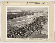
Aerial view of Villasis, circa 1930s
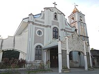
Saint Anthony the Abbot Parish Church

Public Auditorium
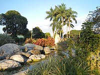
Rizal Park

Villasis Public Market and Bagsakan Center

Bagsakan stores

The vegetable and fruit stores


References[]
- ^ Municipality of Villasis | (DILG)
- ^ "2015 Census of Population, Report No. 3 – Population, Land Area, and Population Density" (PDF). Philippine Statistics Authority. Quezon City, Philippines. August 2016. ISSN 0117-1453. Archived (PDF) from the original on May 25, 2021. Retrieved July 16, 2021.
- ^ a b Census of Population (2020). "Region I (Ilocos Region)". Total Population by Province, City, Municipality and Barangay. PSA. Retrieved 8 July 2021.
- ^ https://psa.gov.ph/sites/default/files/City%20and%20Municipal-level%20Small%20Area%20Poverty%20Estimates_%202009%2C%202012%20and%202015_0.xlsx; publication date: 10 July 2019; publisher: Philippine Statistics Authority.
- ^ "Villasis, Pangasinan: Average Temperatures and Rainfall". World Weather Online. Retrieved 31 October 2015.
- ^ Census of Population (2015). "Region I (Ilocos Region)". Total Population by Province, City, Municipality and Barangay. PSA. Retrieved 20 June 2016.
- ^ Census of Population and Housing (2010). "Region I (Ilocos Region)". Total Population by Province, City, Municipality and Barangay. NSO. Retrieved 29 June 2016.
- ^ Censuses of Population (1903–2007). "Region I (Ilocos Region)". Table 1. Population Enumerated in Various Censuses by Province/Highly Urbanized City: 1903 to 2007. NSO.
- ^ "Province of Pangasinan". Municipality Population Data. Local Water Utilities Administration Research Division. Retrieved 17 December 2016.
- ^ "Poverty incidence (PI):". Philippine Statistics Authority. Retrieved 28 December 2020.
- ^ https://psa.gov.ph/sites/default/files/NSCB_LocalPovertyPhilippines_0.pdf; publication date: 29 November 2005; publisher: Philippine Statistics Authority.
- ^ https://psa.gov.ph/sites/default/files/2003%20SAE%20of%20poverty%20%28Full%20Report%29_1.pdf; publication date: 23 March 2009; publisher: Philippine Statistics Authority.
- ^ https://psa.gov.ph/sites/default/files/2006%20and%202009%20City%20and%20Municipal%20Level%20Poverty%20Estimates_0_1.pdf; publication date: 3 August 2012; publisher: Philippine Statistics Authority.
- ^ https://psa.gov.ph/sites/default/files/2012%20Municipal%20and%20City%20Level%20Poverty%20Estima7tes%20Publication%20%281%29.pdf; publication date: 31 May 2016; publisher: Philippine Statistics Authority.
- ^ https://psa.gov.ph/sites/default/files/City%20and%20Municipal-level%20Small%20Area%20Poverty%20Estimates_%202009%2C%202012%20and%202015_0.xlsx; publication date: 10 July 2019; publisher: Philippine Statistics Authority.
- ^ ABS-CBN Interactive, Balikbayans join Talong fest
External links[]
| Wikimedia Commons has media related to Villasis. |
- Villasis Profile at PhilAtlas.com
- Municipal Profile at the National Competitiveness Council of the Philippines
- Villasis at the Pangasinan Government Website
- Local Governance Performance Management System
- Philippine Standard Geographic Code
- Philippine Census Information
Places adjacent to Villasis | ||||||||||||||||
|---|---|---|---|---|---|---|---|---|---|---|---|---|---|---|---|---|
| ||||||||||||||||
Lingayen (capital) | |
| Municipalities |
|
| Component cities | |
| Independent component city |
|
| Barangays | |
- Municipalities of Pangasinan
- Populated places on the Agno River