Balungao
Balungao | |
|---|---|
| Municipality of Balungao | |
 Balungao Town Hall | |
 Seal | |
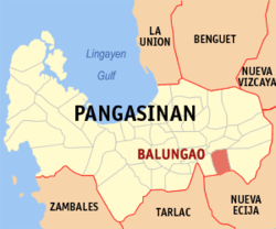 Map of Pangasinan with Balungao highlighted | |
show OpenStreetMap | |
 Balungao Location within the Philippines | |
| Coordinates: 15°54′N 120°42′E / 15.9°N 120.7°ECoordinates: 15°54′N 120°42′E / 15.9°N 120.7°E | |
| Country | Philippines |
| Region | Ilocos Region |
| Province | Pangasinan |
| District | 6th district |
| Founded | March 19, 1815[1] |
| Named for | Mount Balungao |
| Barangays | 21 (see Barangays) |
| Government | |
| • Type | Sangguniang Bayan |
| • Mayor | Maria Theresa R. Peralta |
| • Vice Mayor | Philipp D. Peralta |
| • Representative | Tyrone D. Agabas |
| • Municipal Council | show
Members |
| • Electorate | 20,166 voters (2019) |
| Area | |
| • Total | 73.25 km2 (28.28 sq mi) |
| Elevation | 50 m (160 ft) |
| Highest elevation | 382 m (1,253 ft) |
| Lowest elevation | 29 m (95 ft) |
| Population (2020 census) [4] | |
| • Total | 30,004 |
| • Density | 410/km2 (1,100/sq mi) |
| • Households | 6,891 |
| Economy | |
| • Income class | 4th municipal income class |
| • Poverty incidence | 10.95% (2015)[5] |
| • Revenue | ₱88,743,226.31 (2016) |
| Service provider | |
| • Electricity | Pangasinan 3 Electric Cooperative (PANELCO 3) |
| Time zone | UTC+8 (PST) |
| ZIP code | 2442 |
| PSGC | |
| IDD : area code | +63 (0)75 |
| Climate type | tropical monsoon climate |
| Native languages | Pangasinan Ilocano Tagalog |


Balungao, officially the Municipality of Balungao (Pangasinan: Baley na Balungao; Ilocano: Ili ti Balungao; Tagalog: Bayan ng Balungao), is a 4th class municipality in the province of Pangasinan, Philippines. According to the 2020 census, it has a population of 30,004 people. [4]
The town is located in the south-eastern part of the province bordering the province of Nueva Ecija to the south. Balungao is partially urban community with an area of 7,325 hectares (18,100 acres).[6]
Barangays[]
Balungao is politically subdivided into 20 barangays.
- Angayan Norte
- Angayan Sur
- Capulaan
- Esmeralda
- Kita-kita
- Mabini
- Mauban
- Poblacion
- Pugaro
- Rajal
- San Andres
- San Aurelio 1st
- San Aurelio 2nd
- San Aurelio 3rd
- San Joaquin
- San Julian
- San Leon
- San Marcelino
- San Miguel
- San Raymundo
Climate[]
| hideClimate data for Balungao, Pangasinan | |||||||||||||
|---|---|---|---|---|---|---|---|---|---|---|---|---|---|
| Month | Jan | Feb | Mar | Apr | May | Jun | Jul | Aug | Sep | Oct | Nov | Dec | Year |
| Average high °C (°F) | 29 (84) |
29 (84) |
30 (86) |
32 (90) |
33 (91) |
33 (91) |
33 (91) |
33 (91) |
34 (93) |
32 (90) |
31 (88) |
29 (84) |
32 (89) |
| Average low °C (°F) | 21 (70) |
21 (70) |
22 (72) |
23 (73) |
24 (75) |
24 (75) |
24 (75) |
24 (75) |
23 (73) |
23 (73) |
22 (72) |
21 (70) |
23 (73) |
| Average precipitation mm (inches) | 127.5 (5.02) |
115.8 (4.56) |
129.7 (5.11) |
141.1 (5.56) |
248.2 (9.77) |
165 (6.5) |
185.3 (7.30) |
161.9 (6.37) |
221.4 (8.72) |
299.5 (11.79) |
199 (7.8) |
188.7 (7.43) |
2,183.1 (85.93) |
| Average rainy days | 17 | 17 | 17 | 15 | 20 | 19 | 19 | 20 | 21 | 20 | 17 | 19 | 221 |
| Source: World Weather Online[7] | |||||||||||||
History[]
Early settlers[]
The town of Balungao were first inhabited by nomadic people from the Ilocos region who found their way to the area through San Fabian, Pangasinan. They were farmers looking for places to settle down, engaging in agriculture to survive. Its origin is evident in the fact that Balungao is one of the Ilocano-speaking towns in the province where the primary language is the Pangasinense.[1]
Foundation[]
Balungao was originally called Panaclaban and was a part of Cuyapo town in the adjacent province of Nueva Ecija till the latter part of 18th century. It was annexed to the town of Rosales, Pangasinan in the early part of 19th century because of its geographic location. It officially became an independent municipality in 1815.[1]
Demographics[]
| Year | Pop. | ±% p.a. |
|---|---|---|
| 1903 | 5,853 | — |
| 1918 | 8,515 | +2.53% |
| 1939 | 10,912 | +1.19% |
| 1948 | 12,773 | +1.77% |
| 1960 | 13,184 | +0.26% |
| 1970 | 14,989 | +1.29% |
| 1975 | 16,745 | +2.25% |
| 1980 | 17,342 | +0.70% |
| 1990 | 21,473 | +2.16% |
| 1995 | 21,274 | −0.17% |
| 2000 | 23,813 | +2.45% |
| 2007 | 25,214 | +0.79% |
| 2010 | 26,678 | +2.08% |
| 2015 | 31,106 | +2.97% |
| 2020 | 30,004 | −0.71% |
| Source: Philippine Statistics Authority [8] [9] [10][11] | ||
Economy[]
| Poverty Incidence of Balungao | |
| Source: Philippine Statistics Authority[12][13][14][15][16][17] | |
Places of interest[]
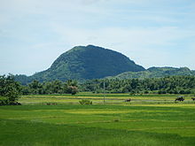
Mount Balungao[]
Mount Balungao (15°51′44.90″N 120°40′57.70″E / 15.8624722°N 120.6826944°E) is an extinct volcano, 382 metres (1,253 ft) ASL located in the municipality of Balungao. Its volcanic past is manifested by its physical profile and the presence of hot and cold springs. The Philippine Institute of Volcanology and Seismology (PHIVOLCS) lists Mount Balungao as an inactive volcano.[18]
Balungao Hilltop Adventure[]
Balungao opened its doors to adventure travel tourism with the opening of Balungao Hilltop Adventure (15°52′2″N 120°41′10″E / 15.86722°N 120.68611°E) on September 8, 2011. Located at the foot of Mount Balungao, the resort was constructed by the municipal government of Balungao and boasts the 2nd longest Zip-line in the Philippines (2011) at 600 metres (2,000 ft) long. The Balungao Hilltop Adventure also offers ATV or quad bike adventure, bungee trampoline, biking, mountain climbing, and the refurbished hot and cold spring swimming pools.
It originally started as the Mt. Balungao Hot and Cold Springs Resort under the administration of then Mayor Jose G. Peralta Jr. It was not until 2011, under the administration of the Mayor Philipp G. Peralta, that it was repackaged for adventure travelers.
Longest Zipline in Pangasinan[]
Balungao Hilltop Adventure offers a Zip Line with a length 600 meters which could last from 15 seconds to a minute depending on your weight and your position when you are suspended at the Zip Line. It begins from a Hill, overlooking the valley passing through another hill down to the Balungao Hot and Cold Spring Resort. It is considered as the longest Zip line in Pangasinan[19]
Education[]
- San Aurelio National High School
- Rajal-Angayan National High School
- Balungao National High School
- Balungao Central High School
- Remnant International School
- San Leon National High School
See also[]
References[]
- ^ Jump up to: a b c "Historical Development" Archived 2012-04-16 at the Wayback Machine. Hataw Balungao. Retrieved on 2012-04-23.
- ^ Municipality of Balungao | (DILG)
- ^ "2015 Census of Population, Report No. 3 – Population, Land Area, and Population Density" (PDF). Philippine Statistics Authority. Quezon City, Philippines. August 2016. ISSN 0117-1453. Archived (PDF) from the original on May 25, 2021. Retrieved July 16, 2021.
- ^ Jump up to: a b Census of Population (2020). "Region I (Ilocos Region)". Total Population by Province, City, Municipality and Barangay. PSA. Retrieved 8 July 2021.
- ^ https://psa.gov.ph/sites/default/files/City%20and%20Municipal-level%20Small%20Area%20Poverty%20Estimates_%202009%2C%202012%20and%202015_0.xlsx; publication date: 10 July 2019; publisher: Philippine Statistics Authority.
- ^ "Province: PANGASINAN". PSGC Interactive. Makati, Philippines: National Statistical Coordination Board. Archived from the original on 14 November 2012. Retrieved 26 November 2012.
- ^ "Balungao, Pangasinan: Average Temperatures and Rainfall". World Weather Online. Retrieved 23 September 2015.
- ^ Census of Population (2015). "Region I (Ilocos Region)". Total Population by Province, City, Municipality and Barangay. PSA. Retrieved 20 June 2016.
- ^ Census of Population and Housing (2010). "Region I (Ilocos Region)". Total Population by Province, City, Municipality and Barangay. NSO. Retrieved 29 June 2016.
- ^ Censuses of Population (1903–2007). "Region I (Ilocos Region)". Table 1. Population Enumerated in Various Censuses by Province/Highly Urbanized City: 1903 to 2007. NSO.
- ^ "Province of Pangasinan". Municipality Population Data. Local Water Utilities Administration Research Division. Retrieved 17 December 2016.
- ^ "Poverty incidence (PI):". Philippine Statistics Authority. Retrieved 28 December 2020.
- ^ https://psa.gov.ph/sites/default/files/NSCB_LocalPovertyPhilippines_0.pdf; publication date: 29 November 2005; publisher: Philippine Statistics Authority.
- ^ https://psa.gov.ph/sites/default/files/2003%20SAE%20of%20poverty%20%28Full%20Report%29_1.pdf; publication date: 23 March 2009; publisher: Philippine Statistics Authority.
- ^ https://psa.gov.ph/sites/default/files/2006%20and%202009%20City%20and%20Municipal%20Level%20Poverty%20Estimates_0_1.pdf; publication date: 3 August 2012; publisher: Philippine Statistics Authority.
- ^ https://psa.gov.ph/sites/default/files/2012%20Municipal%20and%20City%20Level%20Poverty%20Estima7tes%20Publication%20%281%29.pdf; publication date: 31 May 2016; publisher: Philippine Statistics Authority.
- ^ https://psa.gov.ph/sites/default/files/City%20and%20Municipal-level%20Small%20Area%20Poverty%20Estimates_%202009%2C%202012%20and%202015_0.xlsx; publication date: 10 July 2019; publisher: Philippine Statistics Authority.
- ^ "Philippines Institute of Volcanology and Seismology (PHIVOLCS)- List of Inactive Volcanoes" Archived 2008-12-06 at the Wayback Machine
- ^ [1]
External links[]
| Wikimedia Commons has media related to Balungao. |
- Balungao Profile at PhilAtlas.com
- Municipal Profile at the National Competitiveness Council of the Philippines
- Balungao Pangasinan Official Website
- Balungao at the Pangasinan Government Website[permanent dead link]
- Local Governance Performance Management System
- Philippine Standard Geographic Code
- Philippine Census Information
| show Places adjacent to Balungao |
|---|
| show |
|---|
- Municipalities of Pangasinan