Bayambang
Bayambang | |
|---|---|
| Municipality of Bayambang | |
 | |
 Flag  Seal | |
 Map of Pangasinan with Bayambang highlighted | |
show OpenStreetMap | |
 Bayambang Location within the Philippines | |
| Coordinates: 15°43′00″N 120°21′00″E / 15.71667°N 120.35°ECoordinates: 15°43′00″N 120°21′00″E / 15.71667°N 120.35°E | |
| Country | Philippines |
| Region | Ilocos Region |
| Province | Pangasinan |
| District | 3rd district |
| Founded | April 5, 1614[1] |
| Barangays | 77 (see Barangays) |
| Government | |
| • Type | Sangguniang Bayan |
| • Mayor | Cezar T. Quiambao |
| • Vice Mayor | Raul R. Sabangan |
| • Representative | Rose Marie J. Arenas |
| • Municipal Council | show
Members |
| • Electorate | 75,911 voters (2019) |
| Area | |
| • Total | 143.94 km2 (55.58 sq mi) |
| Elevation | 20 m (70 ft) |
| Highest elevation | 48 m (157 ft) |
| Lowest elevation | 11 m (36 ft) |
| Population (2020 census) [4] | |
| • Total | 129,011 |
| • Density | 900/km2 (2,300/sq mi) |
| • Households | 25,004 |
| Economy | |
| • Income class | 1st municipal income class |
| • Poverty incidence | 13.88% (2015)[5] |
| • Revenue | ₱243,337,006.99 (2016) |
| Service provider | |
| • Electricity | Central Pangasinan Electric Cooperative (CENPELCO) |
| Time zone | UTC+8 (PST) |
| ZIP code | 2423 |
| PSGC | |
| IDD : area code | +63 (0)75 |
| Climate type | tropical monsoon climate |
| Native languages | Pangasinan Ilocano Tagalog |
| Website | www |


Bayambang, officially the Municipality of Bayambang (Pangasinan: Baley na Bayambang; Ilocano: Ili ti Bayambang; Tagalog: Bayan ng Bayambang), is a 1st class municipality in the province of Pangasinan, Philippines. According to the 2020 census, it has a population of 129,011 people. [4]
It previously included the municipalities of Bautista, Alcala, Santo Tomas, Rosales, Paniqui, Gerona and Camiling, Tarlac.[6] It was founded in the 16th century by Agalet, an Aeta.
Bayambang is the former seat of the 5th Capital of the Revolutionary Philippine Republic. It celebrates its Malangsi Fishtival (1st week of April, "Kalutan tan Gayaga ed Dalan"). Bayambang is the seat of the Pangasinan State University, the Colleges of Nursing and Education.
Bayambang is proposed to become the 5th city in the province of Pangasinan. An approved resolution unanimously passed by the members of the Municipal Board and the office of Pangasinan 3rd District filed a bill in Congress for the enactment of a Republic Act (RA) converting the municipality into a component city of the province.[7]
Etymology[]
The name of this town according to the legend, came from the name of a plant called "balangbang" (Bauhinia acuminata) which grew in abundance during the early days. "Culibangbang" leaves were used for bulalong Iloko or sinigang. The verdant hills of Bayambang were almost covered by these plants. The people made pickles out of them. As years passed by, these plants became extinct in the vicinity, but the name "Bayambang" which sounds like an echo of the plant's name, was retained and was given to designate this town.
Others believed that the name of the town came from the once numerous "Culibangbang" trees, misunderstood as "Bayambang" by the Spaniards when they first came to this town.[8]
Telbang (Bagbag in Ilokano, Dapdap in other dialects, scientific name: Erythrina variegata Linn. var. orientalis, Linn.) was the original Bayambang according tales. Bayambang is not a tree name, but a plant name: Celosia - Deeringia polysperma (Roxb.) Moq. (as C. polysperma Roxb.).[9]
Geography[]
Bayambang is bounded on the north by Malasiqui, on the south by Camiling, on the east by Bautista, and on the west by Urbiztondo. Bayambang is the southernmost town of the province of Pangasinan. It is the gateway to Tarlac Province in the south.
The town's topography or terrain varies from rolling lands and hills to generally flat plains. Its climate is marked by the wet season from June to October, and dry season from November to May.
Land area: 16,800 hectares
- Total Agricultural Area: 12,225 hectares
- Total Residential Area: 278 hectares
- Total Commercial Area: 9.5 hectares
- Total Institutional Area: 68 hectares
- Forest reserve & Wild Parks: 2,059 hectares
- Total Industrial Area: 15.8 hectares
- Open Space: 2,134.7 hectares
Barangays[]

Bayambang is politically subdivided into 77 barangays,[10] 11 of which are urban barangays and 66 are rural barangays.
- Alinggan
- Amamperez
- Amancosiling Norte
- Amancosiling Sur
- Ambayat I
- Ambayat II
- Apalen
- Asin
- Ataynan
- Bacnono
- Balaybuaya
- Banaban
- Bani
- Batangcaoa
- Beleng
- Bical Norte
- Bical Sur
- Bongato East
- Bongato West
- Buayaen
- Buenlag 1st
- Buenlag 2nd
- Cadre Site
- Carungay
- Caturay
- Darawey (Tangal)
- Duera
- Dusoc
- Hermoza
- Idong
- Inanlorenza
- Inirangan
- Iton
- Langiran
- Ligue
- M. H. del Pilar
- Macayocayo
- Magsaysay
- Maigpa
- Malimpec
- Malioer
- Managos
- Manambong Norte
- Manambong Parte
- Manambong Sur
- Mangayao
- Nalsian Norte
- Nalsian Sur
- Pangdel
- Pantol
- Paragos
- Poblacion Sur
- Pugo
- Reynado
- San Gabriel 1st
- San Gabriel 2nd
- San Vicente
- Sancagulis
- Sanlibo
- Sapang
- Tamaro
- Tambac
- Tampog
- Tanolong
- Tatarac
- Telbang
- Tococ East
- Tococ West
- Warding
- Wawa
- Zone I (Poblacion)
- Zone II (Poblacion)
- Zone III (Poblacion)
- Zone IV (Poblacion)
- Zone V (Poblacion)
- Zone VI (Poblacion)
- Zone VII (Poblacion)
Climate[]
| hideClimate data for Bayambang, Pangasinan | |||||||||||||
|---|---|---|---|---|---|---|---|---|---|---|---|---|---|
| Month | Jan | Feb | Mar | Apr | May | Jun | Jul | Aug | Sep | Oct | Nov | Dec | Year |
| Average high °C (°F) | 31 (88) |
31 (88) |
31 (88) |
33 (91) |
32 (90) |
32 (90) |
30 (86) |
30 (86) |
30 (86) |
31 (88) |
31 (88) |
31 (88) |
31 (88) |
| Average low °C (°F) | 21 (70) |
21 (70) |
22 (72) |
24 (75) |
24 (75) |
24 (75) |
23 (73) |
23 (73) |
23 (73) |
23 (73) |
23 (73) |
22 (72) |
23 (73) |
| Average precipitation mm (inches) | 5.1 (0.20) |
11.6 (0.46) |
21.1 (0.83) |
27.7 (1.09) |
232.9 (9.17) |
350.8 (13.81) |
679.8 (26.76) |
733.1 (28.86) |
505 (19.9) |
176.6 (6.95) |
67.2 (2.65) |
17.7 (0.70) |
2,828.6 (111.38) |
| Average rainy days | 3 | 3 | 3 | 4 | 14 | 18 | 23 | 25 | 22 | 15 | 8 | 4 | 142 |
| Source: World Weather Online (modelled/calculated data, not measured locally)[11] | |||||||||||||
History[]
The "Awarans" account that Benaldo Gutierrez and Honorato Carungay, Bayambang was founded in the early 16th century by an Aeta, Agalet. Bayambang was inside Inirangan and Hermosa, then re-located to Telbang and southern Poblacion, the Old Bayambang.
In 1897, the first "Juez de Cuchillo" executed residents and burned houses. In November 1899, Emilio Aguinaldo designated Bayambang as Pangasinan capital (also during the Japanese Regime), the seat of our short-lived Philippine Republic, due to capture by Gen. Arthur MacArthur of Tarlac on October 12, 1899. Jose P. Rizal visited Camiling, Tarlac's Leonor Rivera, since it was formerly a part of Bayambang. Antonio Luna built a camp in Bayambang. Dr. Diaz became Governor under the Japanese Imperial Government and held Office in Bayambang, at the Eulogio Dauz residence (junction of Quezon Blvd. And M.H. Del Pilar streets).
Bayambang was the seat of the UNESCO National Community Training Center. . Vicente Cayabyab, Gobernadorcillo was the first Chief Executive of the town during the Spanish Regime followed by Mauricio de Guzman, first Cabeza de Barangay (Municipal Captain). Honorato Carungay, Lorenzo Rodriguez and Julian Mananzan succeeded him, and later, Saturnino, Evaristo Dimalanta as president.
Lauriano Roldan became the first Civil Government President, and succeeded by Alvino Garcia, Mateo Mananzan, Gavino de Guzman, Marciano Fajardo, Agustin Carungay, Emeterio Camacho, and Enrique M. Roldan.
The Mayors were: Gerundio Umengan, Leopoldo Aquino, Sr., Ambrosio Gloria (appointed by the PCAU of the Army), Bernardo Lagoy, appointed 1946, Leopoldo Aquino, Sr. (reelected), Eligio C. Sagun (1952-1955), Don Numeriano Castro (appointed), Salvador F. Quinto (1956-1959), Miguel C. Matabang (1960-1963), Jaime P. Junio (1964-1986), Feliciano Casingal, Jr. (OIC), Don Daniel Bato (OIC), Domingo Tagulao, Calixto B. Camacho, Leocadio C. De Vera Jr and Engr. Ricardo M. Camacho.
Dr. Cezar T. Quiambao is the incumbent Municipal Mayor.[8]
In celebration of its 400th year Founding Anniversary on April 5, 2014, Bayambang is declared as the new holder of the Guinness world record for the longest barbecue grill. Turkey's 6.116-kilometerlong grill record was exceeded by the eight-kilometer interconnected grill pads of simultaneously grilled 24,000 kilos of tilapia.
Proclamation No. 131 (Office of the President of the Philippines on March 24, 2011) has declared every 5th day of April as a Non-Working Day in Bayambang.
Cojuangco claim[]
The Cojuangco's Central Azucarera de Tarlac Realty Corporation (CAT) claims ownership of 386.8-hectare estate in 12 barangays in Bayambang, including the site of the 289-hectare Camp Gregg Military Reservation (declared on October 13, 1903, by the US colonial government, turned over to the Philippines on March 27, 1949, and particularly to the Bureau of Lands on September 29, 1949). The Alyansa ng mga Magbubukid sa Gitnang Luson (AMGL, Peasant Alliance in Central Luzon) opposed the Cojuancos.[12]
Cityhood[]
House Bill No. 8826 was filed last March 1, 2021 for the conversion of the municipality of Bayambang into a component city in the province of Pangasinan.[13] The bill is currently pending with the committee on local government since March 2, 2021.
Demographics[]
| Year | Pop. | ±% p.a. |
|---|---|---|
| 1903 | 11,098 | — |
| 1918 | 15,260 | +2.15% |
| 1939 | 25,578 | +2.49% |
| 1948 | 35,171 | +3.60% |
| 1960 | 47,498 | +2.54% |
| 1970 | 56,415 | +1.73% |
| 1975 | 62,808 | +2.18% |
| 1980 | 64,037 | +0.39% |
| 1990 | 79,027 | +2.13% |
| 1995 | 82,913 | +0.90% |
| 2000 | 96,609 | +3.33% |
| 2007 | 103,145 | +0.91% |
| 2010 | 111,521 | +2.88% |
| 2015 | 118,205 | +1.11% |
| 2020 | 129,011 | +1.73% |
| Source: Philippine Statistics Authority [4] [14] [15] [16][17] | ||
- Literacy rate: 92%
- Annual growth rate: 2.6%
- Per-capita income: PhP26,182.00
- Primary livelihood: farming, fishing
Economy[]
| Poverty Incidence of Bayambang | |
| Source: Philippine Statistics Authority[18][19][20][21][22][23] | |
Local government[]
Dr. Cezar T. Quiambao is the incumbent Municipal Mayor and Raul R. Sabangan is the Vice Mayor.
The Municipal Councilors and Officials are: Mylvin "Boying" Junio, Joseph Vincent Ramos, Philip Dumalanta, Benjie De Vera, Junie Angeles, Martin Terrado, Catherine De Vera, Amory Junio and Rogelio P. Dumalanta, Liga ng mga Barangay Pres. and Philip Braham F. Medrano, SK Federation President.[8]
Culture[]
Binasuan is a colorful and lively dance from Bayambang in the Pangasinan province shows off the balancing skills of the dancers. The glasses that the dancers gracefully, yet carefully, maneuver are half-filled with rice wine gracefully who whirl and roll on the floor.
Fish "Buro" is originally made in barangay Bongato. This fermented rice delicacy is made of steamed rice, salt and freshwater fish (either carp, catfish, eel, gurami or "dalag"). Rice Crackers are made in barangay Sangcagulis. This is now becoming a popular merienda among the loca
Tourism[]

On November 27, 2012, half-million people witnessed the malangsi-fish festival, capped by the "kalutan ed dalan " street grilling party. Pista’y Baley's theme is "Unified Bayambang, Progressive Bayambaguenos." Bayambang interesting attractions include:
- The Farmers parade displayed and corn husk products.[24]
- Bayambang District Hospital
- Drum Corp Philippines[25] (27th Lancers)
- Northern Plains Mansions
- CSI and Royal Malls
- Agno River Flood Control Project, Bacnono
- Rock Island Resort
- Mangabul lake
- St. Vincent Ferrer Parish Church
Image gallery[]

Town hall facade
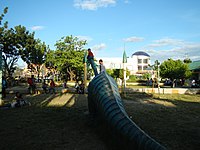
Children's Park
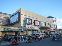
Royal Mall

The Plaza

Public market
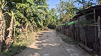
A street on Barangay Langiran


References[]
- ^ About Bayambang
- ^ Municipality of Bayambang | (DILG)
- ^ "2015 Census of Population, Report No. 3 – Population, Land Area, and Population Density" (PDF). Philippine Statistics Authority. Quezon City, Philippines. August 2016. ISSN 0117-1453. Archived (PDF) from the original on May 25, 2021. Retrieved July 16, 2021.
- ^ Jump up to: a b c Census of Population (2020). "Region I (Ilocos Region)". Total Population by Province, City, Municipality and Barangay. PSA. Retrieved 8 July 2021.
- ^ https://psa.gov.ph/sites/default/files/City%20and%20Municipal-level%20Small%20Area%20Poverty%20Estimates_%202009%2C%202012%20and%202015_0.xlsx; publication date: 10 July 2019; publisher: Philippine Statistics Authority.
- ^ "Archived copy". Archived from the original on 2016-08-11. Retrieved 2012-12-18.CS1 maint: archived copy as title (link)
- ^ "Pangasinan town eyes conversion into component city".
- ^ Jump up to: a b c http://www.bayambang.gov.ph/about/[permanent dead link]
- ^ "Archived copy". Archived from the original on 2016-03-04. Retrieved 2012-12-18.CS1 maint: archived copy as title (link)
- ^ "Province: PANGASINAN". PSGC Interactive. Makati City, Philippines: National Statistical Coordination Board. Archived from the original on 14 November 2012. Retrieved 26 November 2012.
- ^ "Bayambang, Pangasinan: Average Temperatures and Rainfall". World Weather Online. Retrieved 26 September 2015.
- ^ "Archived copy". Archived from the original on 2013-09-07. Retrieved 2012-12-18.CS1 maint: archived copy as title (link)
- ^ Arenas, Rose Marie. "AN ACT CONVERTING THE MUNICIPALITY OF BAYAMBANG INTO A COMPONENT CITY OF THE PROVINCE OF PANGASINAN TO BE KNOWN AS THE CITY OF BAYAMBANG" (PDF). House of Representatives. Retrieved April 20, 2021.
- ^ Census of Population (2015). "Region I (Ilocos Region)". Total Population by Province, City, Municipality and Barangay. PSA. Retrieved 20 June 2016.
- ^ Census of Population and Housing (2010). "Region I (Ilocos Region)". Total Population by Province, City, Municipality and Barangay. NSO. Retrieved 29 June 2016.
- ^ Censuses of Population (1903–2007). "Region I (Ilocos Region)". Table 1. Population Enumerated in Various Censuses by Province/Highly Urbanized City: 1903 to 2007. NSO.
- ^ "Province of Pangasinan". Municipality Population Data. Local Water Utilities Administration Research Division. Retrieved 17 December 2016.
- ^ "Poverty incidence (PI):". Philippine Statistics Authority. Retrieved 28 December 2020.
- ^ https://psa.gov.ph/sites/default/files/NSCB_LocalPovertyPhilippines_0.pdf; publication date: 29 November 2005; publisher: Philippine Statistics Authority.
- ^ https://psa.gov.ph/sites/default/files/2003%20SAE%20of%20poverty%20%28Full%20Report%29_1.pdf; publication date: 23 March 2009; publisher: Philippine Statistics Authority.
- ^ https://psa.gov.ph/sites/default/files/2006%20and%202009%20City%20and%20Municipal%20Level%20Poverty%20Estimates_0_1.pdf; publication date: 3 August 2012; publisher: Philippine Statistics Authority.
- ^ https://psa.gov.ph/sites/default/files/2012%20Municipal%20and%20City%20Level%20Poverty%20Estima7tes%20Publication%20%281%29.pdf; publication date: 31 May 2016; publisher: Philippine Statistics Authority.
- ^ https://psa.gov.ph/sites/default/files/City%20and%20Municipal-level%20Small%20Area%20Poverty%20Estimates_%202009%2C%202012%20and%202015_0.xlsx; publication date: 10 July 2019; publisher: Philippine Statistics Authority.
- ^ http://www.bayambang.gov.ph/2012/11/27/malangsi-fishtival-draws-huge-crowd/[permanent dead link]
- ^ http://dctc.webs.com/whoweare.htm[permanent dead link]
External links[]
| Wikimedia Commons has media related to Bayambang. |
- Official website
- Municipal Profile at the National Competitiveness Council of the Philippines
- Bayambang at the Pangasinan Government Website Archived 2016-08-11 at the Wayback Machine
- Local Governance Performance Management System
- Philippine Standard Geographic Code
- Philippine Census Information
| show Places adjacent to Bayambang |
|---|
| show |
|---|
- Municipalities of Pangasinan
- Populated places on the Agno River