Sual
Sual | |
|---|---|
| Municipality of Sual | |
 | |
 Flag  Seal | |
 Map of Pangasinan with Sual highlighted | |
show OpenStreetMap | |
 Sual Location within the Philippines | |
| Coordinates: 16°04′N 120°06′E / 16.07°N 120.1°ECoordinates: 16°04′N 120°06′E / 16.07°N 120.1°E | |
| Country | Philippines |
| Region | Ilocos Region |
| Province | Pangasinan |
| District | 1st district |
| Founded | May 20, 1805 |
| Barangays | 19 (see Barangays) |
| Government | |
| • Type | Sangguniang Bayan |
| • Mayor | Liseldo D. Calugay |
| • Vice Mayor | Dioneil G. Caburao |
| • Representative | Arnold D. Celeste |
| • Municipal Council | show
Members |
| • Electorate | 28,940 voters (2019) |
| Area | |
| • Total | 130.16 km2 (50.26 sq mi) |
| Elevation | 77 m (253 ft) |
| Highest elevation | 387 m (1,270 ft) |
| Lowest elevation | 0 m (0 ft) |
| Population (2020 census) [3] | |
| • Total | 39,091 |
| • Density | 300/km2 (780/sq mi) |
| • Households | 7,817 |
| Economy | |
| • Income class | 1st municipal income class |
| • Poverty incidence | 13.53% (2015)[4] |
| • Revenue | ₱216,238,426.90 (2016) |
| Service provider | |
| • Electricity | Central Pangasinan Electric Cooperative (CENPELCO) |
| Time zone | UTC+8 (PST) |
| ZIP code | 2403 |
| PSGC | |
| IDD : area code | +63 (0)75 |
| Climate type | tropical monsoon climate |
| Native languages | Pangasinan Ilocano Tagalog |


Sual, officially the Municipality of Sual (Pangasinan: Baley na Sual; Ilocano: Ili ti Sual; Tagalog: Bayan ng Sual), is a 1st class municipality in the province of Pangasinan, Philippines. According to the 2020 census, it has a population of 39,091 people. [3]
The Philippines largest coal power plant, the 1200 megawatt Sual Power Station, is located in this municipality. It used to be owned by Mirant Services LLC.
Sual is one of the towns where the Spanish galleon brought their goods to trade.
Barangays[]
Sual is politically subdivided into 19 barangays.
- Baquioen
- Baybay Norte
- Baybay Sur
- Bolaoen
- Cabalitian
- Calumbuyan
- Camagsingalan
- Caoayan
- Capantolan
- Macaycayawan
- Paitan East
- Paitan West
- Pangascasan
- Poblacion
- Santo Domingo
- Seselangen
- Sioasio East
- Sioasio West
- Victoria
Climate[]
| hideClimate data for Sual, Pangasinan | |||||||||||||
|---|---|---|---|---|---|---|---|---|---|---|---|---|---|
| Month | Jan | Feb | Mar | Apr | May | Jun | Jul | Aug | Sep | Oct | Nov | Dec | Year |
| Average high °C (°F) | 31 (88) |
31 (88) |
31 (88) |
33 (91) |
32 (90) |
32 (90) |
30 (86) |
30 (86) |
30 (86) |
31 (88) |
31 (88) |
31 (88) |
31 (88) |
| Average low °C (°F) | 21 (70) |
21 (70) |
22 (72) |
24 (75) |
24 (75) |
24 (75) |
23 (73) |
23 (73) |
23 (73) |
23 (73) |
23 (73) |
22 (72) |
23 (73) |
| Average precipitation mm (inches) | 5.1 (0.20) |
11.6 (0.46) |
21.1 (0.83) |
27.7 (1.09) |
232.9 (9.17) |
350.8 (13.81) |
679.8 (26.76) |
733.1 (28.86) |
505 (19.9) |
176.6 (6.95) |
67.2 (2.65) |
17.7 (0.70) |
2,828.6 (111.38) |
| Average rainy days | 3 | 3 | 3 | 4 | 14 | 18 | 23 | 25 | 22 | 15 | 8 | 4 | 142 |
| Source: World Weather Online[5] | |||||||||||||
Demographics[]
| Year | Pop. | ±% p.a. |
|---|---|---|
| 1903 | 2,986 | — |
| 1918 | 4,286 | +2.44% |
| 1939 | 6,396 | +1.92% |
| 1948 | 7,458 | +1.72% |
| 1960 | 9,412 | +1.96% |
| 1970 | 12,528 | +2.90% |
| 1975 | 14,367 | +2.78% |
| 1980 | 15,796 | +1.91% |
| 1990 | 19,594 | +2.18% |
| 1995 | 20,929 | +1.24% |
| 2000 | 25,832 | +4.62% |
| 2007 | 29,925 | +2.05% |
| 2010 | 31,216 | +1.55% |
| 2015 | 34,149 | +1.73% |
| 2020 | 39,091 | +2.69% |
| Source: Philippine Statistics Authority [6] [7] [8][9] | ||
Economy[]
| Poverty Incidence of Sual | |
| Source: Philippine Statistics Authority[10][11][12][13][14][15] | |
History[]
Sual used to be a part of a town called San Isidro Labrador de Tobuang (now called Labrador). However Sual would separate from this town when an issue was decreed by the Spanish Governor General Rafael Maria de Aguilar. In May 2019, Liseldo D.Q. Calugay, after a landslide victory, end the 15-year reign of the Arcinue clan.
Maritime issues[]
On January, 2008, Bolinao Mayor Alfonso Celeste said the local government will file damage suit against Indonesian owners of the barge APOL 3003. The University of the Philippines Marine Science Institute (UPMSI) stated that the environmental damage was PHP54.9 million. The barge towed by a tug boat from Indonesia to the power plant in Sual on November 27 when Typhoon Mina destroyed its anchor and rope, then hurled it to Ilog Malino reef, spilling 95% of its coal cargo. The hard coal spill spread to 33 hectares (82 acres) of coral and sea grass areas.[16]
Tourism[]
- St. Peter the Martyr Parish Church
- Limahong Beach Resort in Cabalitian island
Gallery[]

Welcome sign

Sual Municipal Hall

Sual Sports and Civic Center

Sual Public Market (Poblacion)
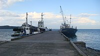
Tugboats and small vessels in the Fish Port Complex
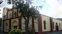
San Pedro Martir Parish Church (Poblacion)


References[]
- ^ Municipality of Sual | (DILG)
- ^ "2015 Census of Population, Report No. 3 – Population, Land Area, and Population Density" (PDF). Philippine Statistics Authority. Quezon City, Philippines. August 2016. ISSN 0117-1453. Archived (PDF) from the original on May 25, 2021. Retrieved July 16, 2021.
- ^ Jump up to: a b Census of Population (2020). "Region I (Ilocos Region)". Total Population by Province, City, Municipality and Barangay. PSA. Retrieved 8 July 2021.
- ^ https://psa.gov.ph/sites/default/files/City%20and%20Municipal-level%20Small%20Area%20Poverty%20Estimates_%202009%2C%202012%20and%202015_0.xlsx; publication date: 10 July 2019; publisher: Philippine Statistics Authority.
- ^ "Sual, Pangasinan: Average Temperatures and Rainfall". World Weather Online. Retrieved 31 October 2015.
- ^ Census of Population (2015). "Region I (Ilocos Region)". Total Population by Province, City, Municipality and Barangay. PSA. Retrieved 20 June 2016.
- ^ Census of Population and Housing (2010). "Region I (Ilocos Region)". Total Population by Province, City, Municipality and Barangay. NSO. Retrieved 29 June 2016.
- ^ Censuses of Population (1903–2007). "Region I (Ilocos Region)". Table 1. Population Enumerated in Various Censuses by Province/Highly Urbanized City: 1903 to 2007. NSO.
- ^ "Province of Pangasinan". Municipality Population Data. Local Water Utilities Administration Research Division. Retrieved 17 December 2016.
- ^ "Poverty incidence (PI):". Philippine Statistics Authority. Retrieved 28 December 2020.
- ^ https://psa.gov.ph/sites/default/files/NSCB_LocalPovertyPhilippines_0.pdf; publication date: 29 November 2005; publisher: Philippine Statistics Authority.
- ^ https://psa.gov.ph/sites/default/files/2003%20SAE%20of%20poverty%20%28Full%20Report%29_1.pdf; publication date: 23 March 2009; publisher: Philippine Statistics Authority.
- ^ https://psa.gov.ph/sites/default/files/2006%20and%202009%20City%20and%20Municipal%20Level%20Poverty%20Estimates_0_1.pdf; publication date: 3 August 2012; publisher: Philippine Statistics Authority.
- ^ https://psa.gov.ph/sites/default/files/2012%20Municipal%20and%20City%20Level%20Poverty%20Estima7tes%20Publication%20%281%29.pdf; publication date: 31 May 2016; publisher: Philippine Statistics Authority.
- ^ https://psa.gov.ph/sites/default/files/City%20and%20Municipal-level%20Small%20Area%20Poverty%20Estimates_%202009%2C%202012%20and%202015_0.xlsx; publication date: 10 July 2019; publisher: Philippine Statistics Authority.
- ^ Inquirer.net, Bolinao to sue barge owners for coal spill Archived 2009-03-12 at the Wayback Machine
External links[]
| Wikimedia Commons has media related to Sual. |
- Sual Profile at PhilAtlas.com
- Municipal Profile at the National Competitiveness Council of the Philippines
- Sual at the Pangasinan Government Website
- Local Governance Performance Management System
- Philippine Standard Geographic Code
- Philippine Census Information
| show Places adjacent to Sual |
|---|
| show |
|---|
- Municipalities of Pangasinan