Akçakale
This article may be expanded with text translated from the corresponding article in Turkish. (November 2020) Click [show] for important translation instructions.
|
Akçakale | |
|---|---|
 Akçakale town | |
 Akçakale | |
| Coordinates: 36°42′39″N 38°56′52″E / 36.71083°N 38.94778°ECoordinates: 36°42′39″N 38°56′52″E / 36.71083°N 38.94778°E | |
| Country | |
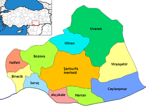
| Province | Şanlıurfa |
| Government | |
| • Mayor | Mehmet Yalçınkaya (AKP) |
| • Kaymakam | Hamza Özer |
| Area | |
| • District | 690.86 km2 (266.74 sq mi) |
| Elevation | 360 m (1,180 ft) |
| Population (2012)[2] | |
| • Urban | 28,684 |
| • District | 91,731 |
| • District density | 130/km2 (340/sq mi) |
| Website | www.akcakale.bel.tr |

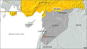
Akçakale (Arabic: تل أبيض; Tal Abyaḍ) is an ethnic Arab town and a district of Şanlıurfa Province, in southeastern Turkey.
Akçakale forms a divided city with Tell Abyad in Syria, maintaining a border crossing. The Mayor is Mehmet Yalçınkaya (AKP).[3] The current District Governor is Hamza Özer.[4]
Syrian Civil War[]
On October 3, 2012, Akçakale was hit by shells from across the Syrian border in Tell Abyad, killing five civilians.[5][6] In October 2014, there was an Islamic State in Iraq and the Levant presence in the town, due to the porous nature of the border at that time between Akçakale and Tell Abyad, which was then part of the Islamic State.[7] When Tell Abyad was taken by the Kurdish-majority People's Protection Units in June 2015, the Turkish government then closed the border.
Transportation[]
Akçakale is at the southern end of the highway.
Sport[]
The Akçakale Belediyespor plays in the Akçakale Ilçe Stadium and competes currently in the Turkish amateur league.[8]
Climate[]
Akçakale has a hot-summer Mediterranean climate (Köppen climate classification: Csa).
| Climate data for Akçakale | |||||||||||||
|---|---|---|---|---|---|---|---|---|---|---|---|---|---|
| Month | Jan | Feb | Mar | Apr | May | Jun | Jul | Aug | Sep | Oct | Nov | Dec | Year |
| Average high °C (°F) | 10 (50) |
13 (55) |
17 (62) |
23 (73) |
29 (84) |
35 (95) |
39 (102) |
38 (100) |
35 (95) |
27 (80) |
19 (66) |
12 (53) |
24 (75) |
| Average low °C (°F) | 1 (33) |
2 (35) |
5 (41) |
9 (48) |
13 (55) |
18 (64) |
21 (69) |
20 (68) |
16 (60) |
11 (51) |
5 (41) |
2 (35) |
10 (50) |
| Average precipitation mm (inches) | 91 (3.6) |
69 (2.7) |
69 (2.7) |
48 (1.9) |
25 (1) |
2.5 (0.1) |
0 (0) |
0 (0) |
0 (0) |
23 (0.9) |
43 (1.7) |
79 (3.1) |
450 (17.8) |
| Source: Weatherbase[9] | |||||||||||||
References[]
- ^ "Area of regions (including lakes), km²". Regional Statistics Database. Turkish Statistical Institute. 2002. Retrieved 2013-03-05.
- ^ "Population of province/district centers and towns/villages by districts - 2012". Address Based Population Registration System (ABPRS) Database. Turkish Statistical Institute. Retrieved 2013-02-27.
- ^ Şafak, Yeni (2019-07-11). "Şanlıurfa Akçakale Seçim Sonuçları – Akçakale Yerel Seçim Sonuçları". Yeni Şafak (in Turkish). Retrieved 2019-11-08.
- ^ "Akçakale Kaymakamlığı". www.akcakale.gov.tr. Retrieved 2019-11-08.
- ^ La Turquie riposte après des tirs d'obus syriens sur son sol, Le Figaro, 04/10/2012
- ^ "Turkey hits targets inside Syria after border deaths". BBC News. 4 October 2012. Retrieved 3 October 2012.
- ^ Khalel, Sheren; Vickery, Matthew (25 October 2014). "No-one here trusts anyone anymore: Inside an Islamic State stronghold". Sunday Herald.
- ^ "Akçakale Belediyespor | Kulüp bilgileri | AmatorFutbol.Org". www.amatorfutbol.org. Retrieved 2020-03-15.
- ^ "Weatherbase: Historical Weather for Akcakale, Turkey". Weatherbase. 2011. Retrieved on 24 November 2011.

| Bulgaria | |
|---|---|
| Greece | |
| Syria | |
| Iraq | |
| Iran | |
| Nakhchivan (Azerbaijan) | |
| Armenia | |
| Georgia | |
- Populated places in Şanlıurfa Province
- Districts of Şanlıurfa Province
- Divided cities on the Turkish-Syrian border
- Syria–Turkey border crossings
- Arab settlements in Turkey