Ayaş, Ankara
This article may be expanded with text translated from the corresponding article in Turkish. (November 2020) Click [show] for important translation instructions.
|
Ayaş | |
|---|---|
District | |
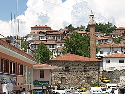 Ayaş district center | |
 Location of Ayaş, Ankara within Turkey. | |
 Ayaş Location of Ayaş, Ankara within Turkey. | |
| Coordinates: 40°01′N 32°21′E / 40.017°N 32.350°E | |
| Country | |
| Region | Central Anatolia |
| Province | Ankara |
| Government | |
| • Governor | Nihat Karabiber |
| • Mayor | Ali Başkaraağaç (CHP) |
| Area | |
| • District | 1,111.74 km2 (429.25 sq mi) |
| Elevation | 910 m (2,990 ft) |
| Population (2012)[2] | |
| • Urban | 8,295 |
| • District | 13,087 |
| • District density | 12/km2 (30/sq mi) |
| Time zone | UTC+3 (TRT) |
| Postal code | 06xxx |
| Area code(s) | 0312 |
| Licence plate | 06 |
| Website | www.ayas.bel.tr |

Ayaş is a town and district of Ankara Province in the Central Anatolia region of Turkey, 58 km from the city of Ankara which is very rich for historical monuments. According to 2000 census, population of the district is 21,239 of which 7,839 live in the urban center of Ayaş.[3][4] The district covers an area of 1,112 km2 (429 sq mi),[5] and the average elevation is 910 m (2,986 ft).
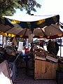
The district is known for its mulberry trees, its tasty tomatoes and its healing mineral water spas, both for drinking and bathing. There is an annual mulberry festival in the town of Ayaş.
The town has a long history and is mentioned in folk songs and the journals of the traveller Evliya Çelebi.
History[]
The citizens of Ayaş were Oghuz tribes as the village names Bayat, Afşar and Peçenek implies. In 1554, it became a sanjak center, and in 1864 it became a Kaza in Ankara Vilayeti. In Ottoman period, education was advanced in Ayaş. In 1900, there were eight medreses, two primary mekteps and one .[6]
Settlements in the district[]
Towns[]
- Ayaş
Villages[]
Picture gallery[]
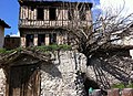
Ayaş houses
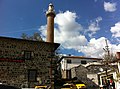
Ulu Cami


See also[]
- Ayaş Tunnel, railway tunnel under construction, which will be Turkey's longest when completed.[7]
Notes[]
- ^ "Area of regions (including lakes), km²". Regional Statistics Database. Turkish Statistical Institute. 2002. Retrieved 2013-03-05.
- ^ "Population of province/district centers and towns/villages by districts - 2012". Address Based Population Registration System (ABPRS) Database. Turkish Statistical Institute. Retrieved 2013-02-27.
- ^ Turkish Statistical Institute. "Census 2000, Key statistics for urban areas of Turkey" (in Turkish). Archived from the original (XLS) on 2007-07-22. Retrieved 2008-03-28.
- ^ GeoHive. "Statistical information on Turkey's administrative units". Retrieved 2008-03-28.
- ^ Statoids. "Statistical information on districts of Turkey". Retrieved 2008-04-23.
- ^ Tuğlacı, Pars (1985). Osmanlı Şehirleri (in Turkish). Milliyet Yayınları. Retrieved 2008-03-28.
- ^ "Arifiye - Sincan Demiryolu Projesi, Ayaş Tüneli" (in Turkish). Nurol İnşaat. Retrieved 2014-04-16.
References[]
- Falling Rain Genomics, Inc. "Geographical information on Ayaş, Turkey". Retrieved 2008-03-28.
- Kenthaber Uluslararası İnternet Med.Yay.Ltd.Şti. "General information on Ayaş district of Ankara" (in Turkish). Archived from the original on 2006-01-08. Retrieved 2008-03-28.
External links[]
| Wikimedia Commons has media related to Ayaş. |
- District governor's official website (in Turkish)
- District municipality's official website (in Turkish)
- Map of Ayaş district (in Turkish)
Ayaş, Ankara in Ankara Province of Turkey | |||||||||||||||||||||||||||
|---|---|---|---|---|---|---|---|---|---|---|---|---|---|---|---|---|---|---|---|---|---|---|---|---|---|---|---|
| Districts |  | ||||||||||||||||||||||||||
|
Metropolitan municipalities are bolded. | |||||||||||||||||||||||||||
Coordinates: 40°01′02″N 32°20′54″E / 40.01722°N 32.34833°E
- Ayaş, Ankara
- Populated places in Ankara Province
- Districts of Ankara Province