Balansun
Balansun | |
|---|---|
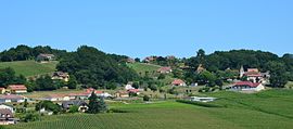 The centre of the village of Balansun | |
show Location of Balansun | |
 Balansun | |
| Coordinates: 43°29′33″N 0°41′51″W / 43.4925°N 0.6975°WCoordinates: 43°29′33″N 0°41′51″W / 43.4925°N 0.6975°W | |
| Country | France |
| Region | Nouvelle-Aquitaine |
| Department | Pyrénées-Atlantiques |
| Arrondissement | Pau |
| Canton | Artix et Pays de Soubestre |
| Intercommunality | Lacq-Orthez |
| Government | |
| • Mayor (2020–2026) | Bénédicte Alcetegaray[1] |
| Area 1 | 10.73 km2 (4.14 sq mi) |
| Population (Jan. 2018)[2] | 293 |
| • Density | 27/km2 (71/sq mi) |
| Time zone | UTC+01:00 (CET) |
| • Summer (DST) | UTC+02:00 (CEST) |
| INSEE/Postal code | 64088 /64300 |
| Elevation | 84–208 m (276–682 ft) (avg. 112 m or 367 ft) |
| 1 French Land Register data, which excludes lakes, ponds, glaciers > 1 km2 (0.386 sq mi or 247 acres) and river estuaries. | |


Balansun (French pronunciation: [balɑ̃sœ̃]; Occitan: Valensun) is a commune of the Pyrénées-Atlantiques department in the Nouvelle-Aquitaine region of south-western France.
The inhabitants of the commune are known as Balansenais or Balansenaises.[3]
Geography[]
Balansun is a commune in the former province of Béarn located some 6 km east of Orthez and 4 km north of Argagnon. Access to the commune is by the D946 road from Arthez-de-Béarn in the east which passes through the centre of the commune south of the village and continues south-west to join the D817 west of Castétis. Access to the village is by the Chemin de l'Eglise which branches north off the D946 on the western side of the commune. The commune is mixed forest and farmland.[4]
The commune is located in the Drainage basin of the Adour with the Ruisseau de Clamondé forming the southern border of the commune as it flows west to join the Gave de Pau west of Castetis. Three streams flow through the commune from east to west into the Ruisseau de Clamondé gathering many tributaries in the commune/
Places and hamlets[]
- Barran
- Bélou
- Bergerayre
- Bernadou
- Bidau
- Bordes
- Bourroua
- Bousque
- Cabalé
- Cabanne
- Cantegrith
- Cantonnier
- Carsuzaa
- Chou
- Cousiner
- Craber
- Crabérou
- Friquet[5]
- Garly
- Heugarès
- Lacabanne
- Laheuguère[5]
- Larribau
- Lasserre
- Lay
- Loup
- Loustalet
- Massioo
- Menaut
- Menusé
- Millet
- Moncaud
- Monhort
- Naudou
- Rouby
- Saint-Martin[5]
- Sarraillot
- Sautié
- Tisnérot
- Touyarot
- Trotemenut
Neighbouring communes and villages[]
| show Places adjacent to Balansun |
|---|
Toponymy[]
Michel Grosclaude said that the origin of the original name is the Gascon Latin name of a man Valentius with the suffix -unum.[6]
The following table details the origins of the commune name and other names in the commune.
| Name | Spelling | Date | Source | Page | Origin | Description |
|---|---|---|---|---|---|---|
| Balansun | Balansun | 1205 | Raymond | Bérérenx | Village | |
| Balansun | 13th century | Raymond | Fors de Béarn | |||
| Balansun | 1323 | Grosclaude | ||||
| Balensu | 1343 | Raymond | Pardies | |||
| Valenssun | 1385 | Raymond | Census | |||
| Valencin | 14th century | Raymond | Froissart | |||
| Balanssun | 1536 | Raymond | Reformation | |||
| Balensun | 18th century | Grosclaude | ||||
| Balensun | 1750 | Cassini | ||||
| Balenzun | 1793 | Ldh/EHESS/Cassini | An II | |||
| Balensun | 1801 | Ldh/EHESS/Cassini | Bulletin des lois | |||
| Bellegarde | Belegarde | 1538 | Raymond | Reformation | Farm and Fief, vassal of the Viscounts of Béarn | |
| Friquet | la maison de Fricquet | 1538 | Raymond | Reformation | Fief, vassal of the Viscounts of Béarn | |
| Laheuguère | La Figuere | 1538 | Raymond | Reformation | Farm | |
| Saint-Martin | Sent-Marthii | 1385 | Raymond | Census | Farm | |
| Tresarbres | Tresarbres | 1538 | Raymond | Reformation | Fief, vassal of the Viscounts of Béarn, with 400 arpents in 1538 |
Sources:
- Grosclaude: Toponymic Dictionary of communes, Béarn, 2006 (in French)[6]
- Raymond: Topographic Dictionary of the Department of Basses-Pyrenees, 1863, on the page numbers indicated in the table. (in French)[5]
- Cassini: Cassini Map from 1750[7]
- Ldh/EHESS/Cassini: Des villages de Cassini aux communes d'aujourd'hui: Commune data sheet Balansun, EHESS. (in French)
Origins:
- Bérérenx: Chapter of Bérérenx[8]
- Fors de Béarn[9]
- Pardies: Notaries of Pardies[10]
- Census: Census of Béarn[11]
- Froissart: Jean Froissart, Book IV
- Reformation: Reformation of Béarn[12]
History[]
Paul Raymond noted that on page 20 of his 1863 dictionary that the fief of Balansun was a vassal of the Viscounts of Béarn and, in 1385, had 27 fires depending on the bailiwick of Pau.
Administration[]
- Mayors from 1942
| From | To | Name |
|---|---|---|
| 1942 | 1944 | Jean Baptiste Daugarou |
| 1944 | 1946 | Pierre Temboury |
| 1946 | 1977 | Alfred Debaig |
| 1977 | 1995 | Jean Sautie |
| 1995 | 2001 | Marie-Thérèse Maubecq |
| 2001 | 2014 | Anny Furbeyre |
| 2014 | 2026 | Bénédicte Alcetegaray |
Inter-communality[]
The commune is part of four inter-communal structures:
- the Communauté de communes de Lacq-Orthez;
- the SIVU of Balansun/Castétis;
- the water and sanitation association of Trois Cantons;
- the Energy association of Pyrénées-Atlantiques;
Demography[]
In 2017 the commune had 287 inhabitants.
|
| ||||||||||||||||||||||||||||||||||||||||||||||||||||||||||||||||||||||||||||||||||||||||||||||||||||||||||||||||||
| Source: EHESS[14] and INSEE[15] | |||||||||||||||||||||||||||||||||||||||||||||||||||||||||||||||||||||||||||||||||||||||||||||||||||||||||||||||||||
Economy[]
Economic activity is mainly agricultural (livestock).
Sites and monuments[]
The Parish Church of the Assumption of Notre-Dame (1850)![]() is registered as an historical monument.[16]
is registered as an historical monument.[16]
Facilities[]
The commune has a primary school which is grouped in an RPI (Intercommunal Educational Grouping) with the primary school in Castétis.
See also[]
References[]
- ^ "Répertoire national des élus: les maires". data.gouv.fr, Plateforme ouverte des données publiques françaises (in French). 2 December 2020.
- ^ "Populations légales 2018". INSEE. 28 December 2020.
- ^ Inhabitants of Pyrénées-Atlantiques (in French)
- ^ Google Maps
- ^ Jump up to: a b c d Topographic Dictionary of the Department of Basses-Pyrenees, Paul Raymond, Imprimerie nationale, 1863, Digitised from Lyon Public Library 15 June 2011 (in French)
- ^ Jump up to: a b Michel Grosclaude, Toponymic Dictionary of communes, Béarn, Edicions reclams & Édition Cairn - 2006, 416 pages, p. 293 ISBN 2-35068-005-3(in French)
- ^ Cassini Map 1750 – Balansun
- ^ Titles of the commune of Bérérenx in the Departmental Archives of Pyrénées-Atlantiques (in French)
- ^ Manuscript from the 14th century in the Departmental Archives of Pyrénées-Atlantiques (in French)
- ^ Departmental Archives of Pyrénées-Atlantiques (in French)
- ^ Manuscript from the 14th century - Departmental Archives of Pyrénées-Atlantiques (in French)
- ^ Manuscript from the 16th to 18th centuries - Departmental Archives of Pyrénées-Atlantiques (in French)
- ^ List of Mayors of France (in French)
- ^ Des villages de Cassini aux communes d'aujourd'hui: Commune data sheet Balansun, EHESS. (in French)
- ^ Population en historique depuis 1968, INSEE
- ^ Ministry of Culture, Mérimée IA64000623 Parish Church of the Assumption of Notre-Dame (in French)
External links[]
| Wikimedia Commons has media related to Balansun. |
- Communes of Pyrénées-Atlantiques