Branges
Branges | |
|---|---|
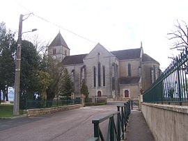 The church in Branges | |
 Coat of arms | |
show Location of Branges | |
 Branges | |
| Coordinates: 46°38′45″N 5°10′31″E / 46.6458°N 5.1753°ECoordinates: 46°38′45″N 5°10′31″E / 46.6458°N 5.1753°E | |
| Country | France |
| Region | Bourgogne-Franche-Comté |
| Department | Saône-et-Loire |
| Arrondissement | Louhans |
| Canton | Louhans |
| Government | |
| • Mayor (2020–2026) | Anthony Vadot[1] |
| Area 1 | 24.59 km2 (9.49 sq mi) |
| Population (Jan. 2018)[2] | 2,359 |
| • Density | 96/km2 (250/sq mi) |
| Time zone | UTC+01:00 (CET) |
| • Summer (DST) | UTC+02:00 (CEST) |
| INSEE/Postal code | 71056 /71500 |
| Elevation | 173–209 m (568–686 ft) (avg. 187 m or 614 ft) |
| 1 French Land Register data, which excludes lakes, ponds, glaciers > 1 km2 (0.386 sq mi or 247 acres) and river estuaries. | |


Branges (French pronunciation: [bʁɑ̃ʒ]) is a commune in the Saône-et-Loire department in the region of Bourgogne-Franche-Comté in eastern France.
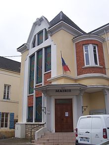
Town hall
See also[]
References[]
- ^ Maires au 17-06-2020, data.gouv.fr, accessed 1 December 2020
- ^ "Populations légales 2018". INSEE. 28 December 2020.
| Wikimedia Commons has media related to Branges. |
| show Authority control |
|---|
This Saône-et-Loire geographical article is a stub. You can help Wikipedia by . |
Categories:
- Communes of Saône-et-Loire
- Saône-et-Loire geography stubs