Bustince-Iriberry
show This article may be expanded with text translated from the corresponding article in French. (December 2008) Click [show] for important translation instructions. |
Bustince-Iriberry
Buztintze-Hiriberri | |
|---|---|
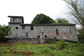 The church of Bustince | |
show Location of Bustince-Iriberry | |
 Bustince-Iriberry | |
| Coordinates: 43°11′21″N 1°10′43″W / 43.1892°N 1.1786°WCoordinates: 43°11′21″N 1°10′43″W / 43.1892°N 1.1786°W | |
| Country | France |
| Region | Nouvelle-Aquitaine |
| Department | Pyrénées-Atlantiques |
| Arrondissement | Bayonne |
| Canton | Montagne Basque |
| Intercommunality | CA Pays Basque |
| Government | |
| • Mayor (2020–2026) | Henry Inchauspé[1] |
| Area 1 | 5.67 km2 (2.19 sq mi) |
| Population (Jan. 2018)[2] | 103 |
| • Density | 18/km2 (47/sq mi) |
| Time zone | UTC+01:00 (CET) |
| • Summer (DST) | UTC+02:00 (CEST) |
| INSEE/Postal code | 64155 /64220 |
| Elevation | 192–383 m (630–1,257 ft) (avg. 257 m or 843 ft) |
| 1 French Land Register data, which excludes lakes, ponds, glaciers > 1 km2 (0.386 sq mi or 247 acres) and river estuaries. | |


Bustince-Iriberry (Basque: Buztintze-Hiriberri) is a commune in the Pyrénées-Atlantiques department in southwestern France.
It is located in the former province of Lower Navarre.
See also[]
References[]
- ^ "Répertoire national des élus: les maires". data.gouv.fr, Plateforme ouverte des données publiques françaises (in French). 2 December 2020.
- ^ "Populations légales 2018". INSEE. 28 December 2020.
External links[]
| Wikimedia Commons has media related to Bustince-Iriberry. |
- BUSTINTZE-HIRIBERRY in the Bernardo Estornés Lasa - Auñamendi Encyclopedia (Euskomedia Fundazioa) (in Spanish)
This Pyrénées-Atlantiques geographical article is a stub. You can help Wikipedia by . |
Categories:
- Communes of Pyrénées-Atlantiques
- Lower Navarre
- Pyrénées-Atlantiques geography stubs