Camou-Cihigue
Camou-Cihigue
Gamere-Zihiga | |
|---|---|
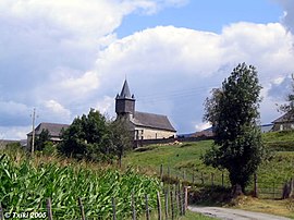 Church of Cihigue | |
show Location of Camou-Cihigue | |
 Camou-Cihigue | |
| Coordinates: 43°07′02″N 0°54′17″W / 43.1172°N 0.9047°WCoordinates: 43°07′02″N 0°54′17″W / 43.1172°N 0.9047°W | |
| Country | France |
| Region | Nouvelle-Aquitaine |
| Department | Pyrénées-Atlantiques |
| Arrondissement | Oloron-Sainte-Marie |
| Canton | Montagne Basque |
| Intercommunality | CA Pays Basque |
| Government | |
| • Mayor (2020–2026) | Charles Anicet Leurgorry |
| Area 1 | 10.08 km2 (3.89 sq mi) |
| Population (Jan. 2018)[1] | 101 |
| • Density | 10/km2 (26/sq mi) |
| Time zone | UTC+01:00 (CET) |
| • Summer (DST) | UTC+02:00 (CEST) |
| INSEE/Postal code | 64162 /64470 |
| Elevation | 208–1,009 m (682–3,310 ft) (avg. 263 m or 863 ft) |
| 1 French Land Register data, which excludes lakes, ponds, glaciers > 1 km2 (0.386 sq mi or 247 acres) and river estuaries. | |


Camou-Cihigue (French pronunciation: [kamu si.iɡ]; Basque: Gamere-Zihiga) is a commune in the Pyrénées-Atlantiques department in south-western France.
It is located in the former province of Soule.
Geography[]
Neughboring communes:
- Ossas-Suhare, in the north
- Aussurucq, in the north-west
- Alos-Sibas-Abense, in the east
- Alçay-Alçabéhéty-Sunharette, in the south
History[]
The commune of Camou-Cihigue was formed in 1836, from the merger of the former commune of Camou Merged and the village of Cihigue.
See also[]
References[]
- ^ "Populations légales 2018". INSEE. 28 December 2020.
External links[]
| Wikimedia Commons has media related to Camou-Cihigue. |
- GAMERE-ZIHIGA in the Bernardo Estornés Lasa - Auñamendi Encyclopedia (Euskomedia Fundazioa) (in Spanish)
| show Municipalities in Soule |
|---|

show This article may be expanded with text translated from the corresponding article in French. (December 2008) Click [show] for important translation instructions. |
This Pyrénées-Atlantiques geographical article is a stub. You can help Wikipedia by . |
Categories:
- Communes of Pyrénées-Atlantiques
- Pyrénées-Atlantiques geography stubs