Cercy-la-Tour
Cercy-la-Tour | |
|---|---|
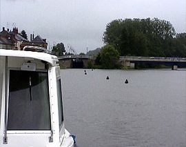 River Aron in Cercy-la-Tour | |
 Coat of arms | |
show Location of Cercy-la-Tour | |
 Cercy-la-Tour | |
| Coordinates: 46°52′10″N 3°38′45″E / 46.8694°N 3.6458°ECoordinates: 46°52′10″N 3°38′45″E / 46.8694°N 3.6458°E | |
| Country | France |
| Region | Bourgogne-Franche-Comté |
| Department | Nièvre |
| Arrondissement | Château-Chinon |
| Canton | Luzy |
| Intercommunality | Bazois Loire Morvan |
| Government | |
| • Mayor (2020–2026) | Sébastien Descreaux[1] |
| Area 1 | 45.57 km2 (17.59 sq mi) |
| Population (Jan. 2018)[2] | 1,730 |
| • Density | 38/km2 (98/sq mi) |
| Time zone | UTC+01:00 (CET) |
| • Summer (DST) | UTC+02:00 (CEST) |
| INSEE/Postal code | 58046 /58340 |
| Elevation | 191–253 m (627–830 ft) |
| 1 French Land Register data, which excludes lakes, ponds, glaciers > 1 km2 (0.386 sq mi or 247 acres) and river estuaries. | |


Cercy-la-Tour (French pronunciation: [sɛʁsi la tuʁ]) is a commune in the Nièvre department in central France.
Geography[]
The village is located in the middle of the commune, where the river Alène joins the Aron.
Demographics[]
At the 1999 census, the population was 2,108. On 1 January 2017, the estimate was 1,746.
See also[]
References[]
- ^ "Répertoire national des élus: les maires". data.gouv.fr, Plateforme ouverte des données publiques françaises (in French). 2 December 2020. Retrieved 7 December 2020.
- ^ "Populations légales 2018". INSEE. 28 December 2020.
External links[]
| Wikimedia Commons has media related to Cercy-la-Tour. |
| show Authority control |
|---|
This Nièvre geographical article is a stub. You can help Wikipedia by . |
Categories:
- Communes of Nièvre
- Nivernais
- Nièvre geography stubs