City of Stonnington
| City of Stonnington Victoria | |||||||||||||||
|---|---|---|---|---|---|---|---|---|---|---|---|---|---|---|---|
 | |||||||||||||||
| Population | 116,207 (2018)[1] | ||||||||||||||
| • Density | 4,522/km2 (11,711/sq mi) | ||||||||||||||
| Established | 1994 | ||||||||||||||
| Area | 25.7 km2 (9.9 sq mi)[1] | ||||||||||||||
| Council seat | Malvern | ||||||||||||||
| State electorate(s) | |||||||||||||||
| Federal Division(s) | Higgins | ||||||||||||||
| Website | City of Stonnington | ||||||||||||||
| |||||||||||||||
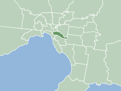
The City of Stonnington is a local government area located within the metropolitan area of Melbourne, Australia. It comprises the inner south-eastern suburbs, between 3 and 13 km (2 and 8 mi), from the Melbourne CBD. The city covers an area of 25.7 km2 (9.9 sq mi).[1]
Within twenty years of the settlement of Melbourne in 1835, the Prahran Municipality (later City of Prahran) was formed in 1855, followed by the Gardiner Road Board (later City of Malvern) in 1856.[citation needed]
The late 19th century saw substantial residential and commercial development such that by 1891 Prahran had a population of almost 40,000 and Malvern 11,000.[citation needed] Following the election of the Kennett government in the Spring of 1992, as part of a comprehensive reorganisation of local government in Victoria, the Cities of Malvern and Prahran were amalgamated to form the City of Stonnington.
The logo of the City of Stonnington features two interlocking celebratory ribbons representing the coming together of the two former cities of Malvern and Prahran.[2]
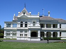
Following the amalgamation of the cities the Malvern Town Hall was renamed the Stonnington City Centre and it became the corporate headquarters of the new Stonnington City Council. In 2015, the new Stonnington City Centre, opposite at 311 Glenferrie Road, was opened and the Malvern Town Hall reverted to its original name.
The name Stonnington comes from Stonington mansion, the Charles D'Ebro-designed mansion built in 1890 for a founding partner of Cobb and Co, John Wagner, who named the house after his wife's birthplace in Stonington (sic), Connecticut, USA.[2] The house is located in Glenferrie Road, Malvern.[2]
The City of Stonnington had a population of 116,207 in June 2018.[1]
History[]


Prior to European settlement, the land of the City of Stonnington was occupied by the Wurundjeri, an Indigenous Australian Woiwurrung speaking people of the Kulin nation.
The establishment of European settlers in what was then the Port Phillip District of New South Wales in 1835, was soon followed by pastoralist John Gardiner, together with Joseph Hawdon and John Hepburn, driving cattle south from Yass to Kooyong Koot (later named Gardiner's) Creek, in the area now known as Malvern and establishing a homestead and grazing property.
The year 1840 was the beginning of Crown land auctions of land to the east of Melbourne and south of the Yarra River and Gardiners Creek. The high ground between Gardiner's Creek Road (now Toorak Road) and the river returned the best prices and it was here that most of the grand mansions of the period were built. Much of the land south of Toorak Road was swampy. This area was subdivided into much smaller blocks, for workman's cottages and later to house gold-rush immigrants. The distinction between the two areas remains today in the suburbs of Toorak and South Yarra. Further auctions of land in the Prahran area took place in 1849 and 1850.
The early 1850s saw the return of many miners from the gold diggings to Prahran, resulting in increased development and the gazetting as a municipality in 1855. The population of Prahran at the time of the first council elections was about 8,000. Meanwhile, Government land sales within the area bounded by Kooyong Road, Gardiners Creek and Wattletree Road were held in 1854 and a small settlement grew around Malvern and Glenferrie Roads. The area known as Gardiner (later Malvern) was proclaimed a Roads Board District in 1856 and became a municipality in 1871, taking the name Malvern in 1878.
The 1880s and 1890s saw substantial residential and commercial development in the City of Prahran, such that by 1891 Prahran had a population of almost 40,000. The development of Malvern followed from 1900 onwards and by 1921 Malvern's population was almost 33,000.
Geography[]
The western part of the city, around South Yarra, Prahran and Windsor, were originally part of the River Yarra flood plain and much of the area was covered by swamps, bogs, and creeks, formed from the run-off from the Malvern Hills to the east. The Albert Park Lake to the west is a remnant of the original flood plain.
The City of Stonnington is bounded by the Yarra River and Gardiners Creek to the north, Warrigal Road to the east, Dandenong Road and Queens Way to the south and Punt Road to the west. Stonnington has numerous tree-lined streets and 126 parks and gardens as well as 27 off-leash parks . Many public reserves occur along the Gardiners Creek valley. The city has some of Melbourne's major shopping precincts in Chapel Street, Glenferrie Road, High Street, Malvern Road and Toorak Road, as well as the Chadstone Shopping Centre. Local sporting venues include Malvern Valley Golf Club, Kooyong Lawn Tennis Club and Harold Holt Memorial Swimming Centre.
Suburbs list is previously mentioned
Demographics[]
The following demographic information is from the 2011 Census of Population and Housing, Australian Bureau of Statistics.
- Population – Stonnington has a population of 93,145, of which 52% are female. There are 39,105 occupied dwellings in the city.[3]
- Age – The age structure of the population of Stonnington is different from the Greater Melbourne average with a higher percentage of persons aged 25–34 (21.9%) and a lower percentage of children aged under 15 (13.1%).[3]
- Country of birth – Stonnington has a multicultural population with 29% being born overseas. The top five countries of birth are England, India, China, New Zealand and Greece.[3]
- Language spoken – In 27.6% of homes a language other than English is spoken. The top five languages are Greek, Mandarin, Cantonese, Italian, and Hindi.[3]
- Religious affiliation – 20.8% of people stated their religion as Catholic, 27.2% as no religion, 14.9% as Anglican and 5.7% as Eastern Orthodox.[3]
- Weekly income – The median household income is $1,722. Stonnington has a higher household income when compared to the Greater Melbourne median of $1,333.[3]
- Occupation – 57.4% of the populations gave their occupation as Professional or Manager, compared to the Greater Melbourne average of 36.6%.[3]
- Employment – The unemployment rate in Stonnington was 4.4% compared to 5.5% in Greater Melbourne (4.4%).[3]
- Dwellings – Stonnington has a higher proportion of medium or high density dwellings (64%), compared to the Greater Melbourne average of 28%.[3]
- Housing loan repayments – The median monthly housing loan repayment in Stonnington was $2,447, compared to the Greater Melbourne average of $1,800.[3]
- Households renting - 43.4% are renting compared to 27% in Greater Melbourne.[3]
Council[]
Stonnington City Council | |
|---|---|
| Structure | |
 | |
Council political groups | Independent (4) Greens (2) Liberal (2) Labor (1) |
| Party | Councillors | |
|---|---|---|
| Independent | 4 | |
| Greens | 2 | |
| Liberal | 2 | |
| Labor | 1 | |
| Total | 9 | |
| Ward | Councillor | Party | Notes | |
|---|---|---|---|---|
| East | Polly Morgan | Greens | ||
| Jami Klisaris | Labor | |||
| Alexander Lew | Liberal | |||
| North | Matthew Koce | Left leaning Liberal party member who votes with the Greens | ||
| Marcia Griffin | Liberal | |||
| Kate Hely | Left leaning Independent | |||
| South | Melina Sehr | Independent | ||
| Mike Scott | Greens | |||
| Nicki Batagol | Left leaning Independent | |||
Mayors[]
From 1996 until 2004, the mayor was elected annually for the following 12 months in March. From 2004 the election took place in November or December. There was a truncated transitional term of office from March to November 2004.
The current mayor is Kate Hely.
Suburbs[]
- Armadale
- Glen Iris (Shared with the City of Boroondara)
- Kooyong
- Malvern
- Malvern East
- Prahran
- South Yarra (Shared with the City of Melbourne)
- Toorak
- Windsor (Shared with the City of Port Phillip)
Education[]
Australia has a system of public (state government) and private (independent) schools. Most public schools are co-educational. Most private schools are administered by their own boards and receive a government subsidy besides having their own fee structure.
Secondary education[]
Schooling is compulsory for students until the age of fifteen, although many students continue on to complete Year 12. The following are secondary colleges (high schools) in the City of Stonnington:
- De La Salle College, Malvern
- St Kevin's College, Toorak
- The King David School, Armadale
- Korowa Anglican Girls' School, Glen Iris
- Lauriston Girls' School, Armadale
- Loreto Mandeville Hall, Toorak
- Presentation College, Windsor (1873-2020, closed due to lack of enrolments)
- Sacré Cœur School, Glen Iris
- St Catherine's School, Toorak
- Melbourne High School, South Yarra
- Prahran High School, Prahran
Tertiary education[]
- The Prahran Mechanics' Institute was established in 1854. It grew to have a focus on the arts. The teaching branch of this organisation has gone through numerous changes since then, including becoming a campus of Swinburne University of Technology in 1992, and of Melbourne Polytechnic in 2013.[4]
- Toorak Teachers' College was established in Malvern in 1957. This became part of Deakin University in 1991, which chose to close it in 2006.[5]
- "Christ College", which ultimately became the Christ Campus of the Australian Catholic University, was in Chadstone/East Malvern until the year 2000.
Public transport[]
Stonnington is extremely well serviced by Melbourne's public transport system. Three suburban railway lines and eight tram services pass through the City of Stonnington, as well as a number of bus services, including 12 services to Chadstone Shopping Centre.
Railways[]
The Cranbourne, Pakenham and Frankston railway lines provide a regular service to South Yarra, Hawksburn, Toorak, Armadale and Malvern stations. The Sandringham railway line services South Yarra, Prahran and Windsor stations and the Glen Waverley line runs along the northern boundary of Stonnington to Heyington, Kooyong, Tooronga, Gardiner, Glen Iris, Darling, East Malvern and Holmesglen stations.
Trams[]
All major east-west roads in Stonnington have tram services. Route 3 runs along Balaclava Road and Waverly Road to East Malvern and tram route 5 services Dandenong Road and Wattletree Road and ends at Burke Road in Malvern. Route 6 runs along High Street and terminates at Malvern Road in Glen Iris, while route 72 services Commercial Road, Malvern Road and Burke Road and route 58 travels along Toorak Road and ends at Glenferrie Road in Toorak. Route 78 runs north-south along Chapel Street and Route 16 along Glenferrie Road.
Media[]
In Stonnington is the City of Stonnington's bi-monthly community newsletter that is delivered to all residents. It features a range of information to help keep residents informed of the latest Council news and views, as well as issues affecting the City. In 2014 Stonnington started producing an electronic version of InStonnington along with the printed edition.
In addition to the newspapers, radio and television of the Melbourne media Stonnington has a free local newspaper, the Leader Newspaper Group's Stonnington Leader, which is a part of News Limited. It has a circulation of about 50,000.
See also[]
References[]
- ^ Jump up to: a b c d "3218.0 – Regional Population Growth, Australia, 2017-18: Population Estimates by Local Government Area (ASGS 2018), 2017 to 2018". Australian Bureau of Statistics. Australian Bureau of Statistics. 27 March 2019. Retrieved 25 October 2019. Estimated resident population, 30 June 2018.
- ^ Jump up to: a b c "History of Stonnington". City of Stonnington. Retrieved 28 May 2020.
- ^ Jump up to: a b c d e f g h i j k Australian Bureau of Statistics (31 October 2012). "Stonnington (Local Government Area)". 2011 Census QuickStats. Retrieved 12 March 2015.

- ^ McKay, Holly (23 August 2012). "Staff and students march to save Swinburne Prahran". Progress Leader. Archived from the original on 25 August 2012. Retrieved 31 October 2012.
- ^ "Sale of the Melbourne Campus at Toorak". Deakin University. Retrieved 31 October 2012.
- 10 Years in the making 1994–2004
- Betty Malone's introduction to Sally Wilde's 'History of Prahran, Vol II: 1925–1990'. Retrieved 14 March 2006
- City of Stonnington Community Profile. Retrieved 12 March 2006
- Victorian Electoral Commission – Results for Stonnington City Council Elections 2004. Retrieved 9 March 2006
- John Butler Cooper, The History of Prahran. Retrieved 29 June 2009
- John Butler Cooper, The History of Malvern. Retrieved 29 June 2009
- Stonnington Mayors and Councillors : Past and Present. Retrieved 27 June 2009
External links[]
| Wikivoyage has a travel guide for Stonnington. |
Coordinates: 37°51′22″S 145°01′46″E / 37.856245°S 145.029563°E

| Authority control |
|
|---|
- Populated places established in 1994
- 1994 establishments in Australia
- Local government areas in Melbourne