Shire of Wellington
| Shire of Wellington Victoria | |||||||||||||||
|---|---|---|---|---|---|---|---|---|---|---|---|---|---|---|---|
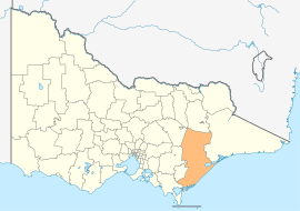 Location in Victoria | |||||||||||||||
| Population | 44,019 (2018)[1] | ||||||||||||||
| • Density | 4.06943/km2 (10.5398/sq mi) | ||||||||||||||
| Established | 1994 | ||||||||||||||
| Gazetted | 2 December 1994[2] | ||||||||||||||
| Area | 10,817 km2 (4,176.5 sq mi)[1] | ||||||||||||||
| Mayor | Cr Garry Stephens [3] | ||||||||||||||
| Council seat | Sale | ||||||||||||||
| Region | Eastern Victoria | ||||||||||||||
| State electorate(s) | |||||||||||||||
| Federal division(s) | Gippsland | ||||||||||||||
 | |||||||||||||||
| Website | Shire of Wellington | ||||||||||||||
| |||||||||||||||
The Shire of Wellington is a local government area in Victoria, Australia, located in the eastern part of the state. It covers an area of 10,817 square kilometres (4,176 sq mi) and in June 2018 had a population of 44,019.
It includes the towns of Heyfield, Rosedale, Maffra, Sale, Stratford, Coongulla, Newry, Tinamba and Yarram. It was formed in 1994 from the amalgamation of the Shire of Alberton, Shire of Avon, Shire of Maffra, City of Sale and parts of the Shire of Rosedale.[2]
The Shire is governed and administered by the Wellington Shire Council; its seat of local government and administrative centre is located at the council headquarters in Sale, it also has service centres located in Maffra, Stratford and Rosedale. The Shire is named after a major geographical feature in the region, Lake Wellington, which is located in the south-east of the LGA.
Council[]
Current composition[]
The Council is composed of three wards and nine councillors, with three councillors per ward elected to represent each ward.[4][5]
| Ward | Councillor | Notes | |
|---|---|---|---|
| Northern | Carolyn Crossley | Former mayor (2015, 2017 and 2018)[6][7] | |
| Carmel Ripper | Elected on countback[8] | ||
| John Tatterson | |||
| Central | Ian Bye | ||
| Jill Wood | |||
| Scott Rossetti | Former mayor (2010, 2013 and 2014)[9] | ||
| Coastal | Marcus McKenzie | ||
| Gayle Maher | |||
| Garry Stephens | Current mayor | ||
Administration and governance[]

The Council meets in the Council Chambers of the Wellington Centre in the Port of Sale precinct at 70 Foster Street, which also houses the Gippsland Art Gallery, Visitor Information Centre and Sale Library.[10] The council headquarters are located over the road at 18 Desailly Street which is the location of the council's administrative activities.[11] It also provides customer services at its service centres in Maffra, Stratford, Rosedale and Yarram.
Main towns in shire[]
In June 2018 the shire had a population of 44,019.[1]
| Population | |
| Locality | Total |
| Alberton | 262 |
| Alberton West | 81 |
| Boisdale | 275 |
| Briagolong | 1,081 |
| 188 | |
| Bushy Park | 50 |
| Carrajung | 102 |
| 232 | |
| Coongulla | 183 |
| Cowwarr | 368 |
| Dargo | 99 |
| 469 | |
| 334 | |
| Population | |
| Locality | Total |
| Fernbank | 152 |
| Flynn | 180 |
| 951 | |
| Glenmaggie | 277 |
| Golden Beach | 293 |
| Gormandale | 321 |
| 125 | |
| Heyfield | 1,993 |
| Hollands Landing | 15 |
| Jack River | 301 |
| Kilmany | 171 |
| Licola | 11 |
| Loch Sport | 814 |
| Population | |
| Locality | Total |
| Longford | 930 |
| Maffra | 4,316 |
| Manns Beach | 135 |
| McLoughlins Beach | 282 |
| Munro | 143 |
| 127 | |
| 299 | |
| Newry | 427 |
| Paradise Beach | 160 |
| 135 | |
| Port Albert | 293 |
| 149 | |
| Rosedale | 1,654 |
| Population | |
| Locality | Total |
| Sale | 15,135 |
| Seaspray | 322 |
| Seaton | 157 |
| 172 | |
| Stratford | 2,617 |
| Tarraville | 80 |
| Tinamba | 277 |
| Valencia Creek | 152 |
| Woodside | 364 |
| Woodside Beach | 95 |
| 222 | |
| Wurruk | 1,112 |
| Yarram | 2,135 |
See also[]
- Central Gippsland
- East Gippsland
- List of localities (Victoria)
References[]
- ^ a b c "3218.0 – Regional Population Growth, Australia, 2017-18: Population Estimates by Local Government Area (ASGS 2018), 2017 to 2018". Australian Bureau of Statistics. Australian Bureau of Statistics. 27 March 2019. Retrieved 25 October 2019. Estimated resident population, 30 June 2018.
- ^ a b Victoria Government Gazette – Online Archive (1837–1997). "S94 of 1994: Order estg (Part 7) the Shire of Wellington". State Library of Victoria. State Government of Victoria (published 2 December 1994). p. 3. Retrieved 10 January 2014.
- ^ Braithwaite, David (13 November 2020). "Garry Stephens elected Wellington Shire mayor". Gippsland Times. Retrieved 14 November 2020.
- ^ Local Government in Victoria. "Wellington Shire Council". Department of Transport, Planning and Local Infrastructure. State Government of Victoria. Retrieved 10 January 2014.
- ^ "Councillors".
- ^ "Councillor Profile: Cr Carolyn Crossley".
- ^ http://www.gippslandtimes.com.au/story/5043774/crossley-re-elected-mayor/
- ^ "Councillor Profile: Cr Carmel Ripper".
- ^ "Councillor Profile: Cr Scott Rossetti".
- ^ http://www.wellington.vic.gov.au/Lists/News-and-Public-Notices/%E2%80%98The-Port%E2%80%99-Project-Update
- ^ http://www.wellington.vic.gov.au/Contact-Us
External links[]
- Wellington Shire Council official website
- Metlink local public transport map
- Link to Land Victoria interactive maps
Coordinates: 37°53′00″S 146°59′00″E / 37.88333°S 146.98333°E

This Australian government-related article is a stub. You can help Wikipedia by . |
This article about a location in Gippsland (region) is a stub. You can help Wikipedia by . |
- Populated places established in 1994
- 1994 establishments in Australia
- Local government areas of Victoria (Australia)
- Gippsland
- Shire of Wellington
- Australia government stubs
- Gippsland geography stubs