City of Hobsons Bay
| City of Hobsons Bay Victoria | |||||||||||||||
|---|---|---|---|---|---|---|---|---|---|---|---|---|---|---|---|
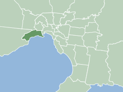 Location within Melbourne metropolitan area | |||||||||||||||
| Population | 96,470 (2018)[1] | ||||||||||||||
| • Density | 1,507/km2 (3,904/sq mi) | ||||||||||||||
| Established | June 1994 | ||||||||||||||
| Area | 64 km2 (24.7 sq mi)[1] | ||||||||||||||
| Mayor | Cr Jonathon Marsden (Greens) | ||||||||||||||
| Council seat | Altona | ||||||||||||||
| Region | Metropolitan Melbourne | ||||||||||||||
| State electorate(s) | |||||||||||||||
| Federal division(s) | |||||||||||||||
| Website | City of Hobsons Bay | ||||||||||||||
| |||||||||||||||

The City of Hobsons Bay is a local government area in Melbourne, Victoria, Australia. It comprises the south-western suburbs between 6 and 20 km from the Melbourne city centre.
It was founded on 22 June 1994 during the amalgamation of local councils by the state government from the City of Williamstown and the City of Altona, as well as the suburb of South Kingsville from the City of Footscray. It took its name from Hobsons Bay, named after Captain William Hobson. The city has an area of 64 square kilometres, and in June 2018 had a population of 96,470.[1]
Council[]
The current councillors, in order of election at the 2020 election, are:[2]
| Ward | Party | Councillor | Notes | |
|---|---|---|---|---|
| Cherry Lake | Independent | Tony Briffa | ||
| Independent | Daria Kellander | |||
| Strand | Greens | Jonathon Marsden | Mayor | |
| Independent | Peter Hemphill | |||
| Independent | Pamela Sutton-Legaud | |||
| Wetlands | Labor | Matt Tyler | ||
| Independent | Diana Grima | |||
Education[]
Libraries[]
The library, run by the council has five branches: Altona, Altona Meadows, Altona North, Newport and Williamstown. Reflecting the multiculturalism of the community, the library service has a large amount of material in eight different languages.
The Environment Resource Centre is located in Altona library and provides the community access to resources concerning the environment, including initiatives and environmental groups in Hobsons Bay.
Transport[]
Suburban railway[]
Hobsons Bay has seven train stations on the Werribee railway line, in PTV Zones 1 and 2. These stations are Spotswood, Newport, Seaholme, Altona, Westona, Laverton and Aircraft. Previously on this line were the stations of Mobiltown, Paisley, and Galvin.
Williamstown railway line is another service which runs through Hobsons Bay. It departs the Werribee railway line at Newport and visits the stations of North Williamstown, Williamstown Beach, and Williamstown.
Freeways[]
The interchange between the West Gate Freeway, Western Ring Road and Princes Freeway lies in the north-west of Hobsons Bay.
From Hobsons Bay, the West Gate Freeway provides access to the Melbourne CBD and eastern suburbs (over the iconic West Gate Bridge), the Princes Freeway provides access to outer south-western suburbs and Geelong, while the Western Ring Road leads to the northern suburbs and Melbourne Airport.
Suburbs[]

- Altona
- Altona Meadows
- Altona North
- Brooklyn (Shared with the City of Brimbank)
- Laverton (Shared with the City of Wyndham)
- Newport
- Seabrook
- Seaholme
- South Kingsville
- Spotswood
- Williamstown
- Williamstown North
Sister Cities[]
 Anjo, Aichi, Japan[3]
 Shire of Buloke, Victoria, Australia (friendship alliance)
See also[]
- List of places on the Victorian Heritage Register in the City of Hobsons Bay
- List of Melbourne suburbs
References[]
- ^ a b c "3218.0 – Regional Population Growth, Australia, 2017-18: Population Estimates by Local Government Area (ASGS 2018), 2017 to 2018". Australian Bureau of Statistics. Australian Bureau of Statistics. 27 March 2019. Retrieved 25 October 2019. Estimated resident population, 30 June 2018.
- ^ "Hobsons Bay City Council election results 2020". www.vec.vic.gov.au. Retrieved 13 November 2020.
- ^ "International Exchange". List of Affiliation Partners within Prefectures. Council of Local Authorities for International Relations (CLAIR). Archived from the original on 24 December 2015. Retrieved 21 November 2015.
External links[]
- Hobsons Bay City Council
- Hobsons Bay Community Online Forum
- Metlink local public transport map
- Link to Land Victoria interactive maps
- The Times - publisher of Hobsons Bay Times

- Local government areas in Melbourne
- 1994 establishments in Australia