Shire of Murrindindi
| Shire of Murrindindi Victoria | |||||||||||||||
|---|---|---|---|---|---|---|---|---|---|---|---|---|---|---|---|
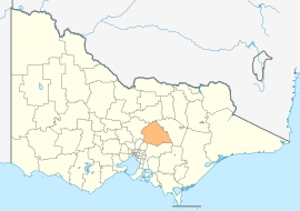 Location in Victoria | |||||||||||||||
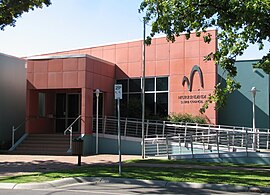 Council Offices in Alexandra | |||||||||||||||
| Population | 14,478 (2018)[1] | ||||||||||||||
| • Density | 3.731/km2 (9.664/sq mi) | ||||||||||||||
| Established | 1994 | ||||||||||||||
| Gazetted | 18 November 1994[2] | ||||||||||||||
| Area | 3,880 km2 (1,498.1 sq mi)[1] | ||||||||||||||
| Mayor | Sandice McAulay | ||||||||||||||
| Council seat | Alexandra | ||||||||||||||
| Region | Hume | ||||||||||||||
| State electorate(s) | Eildon | ||||||||||||||
| Federal division(s) | Indi | ||||||||||||||
| Website | Shire of Murrindindi | ||||||||||||||
| |||||||||||||||
The Shire of Murrindindi is a local government area in the Hume region of Victoria, Australia, located in the north-east part of the state. It covers an area of 3,880 square kilometres (1,500 sq mi) and, in June 2018, had a population of 14,478.[1] It includes the towns of Alexandra, Buxton, Eildon, Flowerdale, Kinglake, Marysville, Molesworth, Strath Creek, Taggerty, Yarck and Yea. It was formed in 1994 from the amalgamation of the Shire of Alexandra, Shire of Yea, and parts of the Shire of Broadford, Shire of Eltham, Shire of Euroa, Shire of Healesville and City of Whittlesea.[2]
The Shire is governed by the Murrindindi Shire Council; its seat of local government and administrative centre is located at the council headquarters in Alexandra, it also has service centres located in Kinglake and Yea. The Shire is named after the locality of Murrindindi, which is located near the geographical centre of the LGA.
Parts of Murrindindi were badly affected by the 2009 Victorian bushfires, notably the towns of Marysville and Kinglake. In total, 106 people lost their lives across the Shire including 38 in Kinglake and 34 in Marysville.
The Lake Mountain ski resort is an unincorporated area near the southern border of the shire, which creates a small exclave.
Council[]
Current composition[]
The council is composed of seven wards and seven councillors, with one councillor elected to represent each ward.[3]
| Ward | Councillor |
|---|---|
| Cathedral | Sandice McAulay |
| Cheviot | Sue Carpenter |
| Eildon | Karine Haslem |
| King Parrot | Eric Lording |
| Kinglake | Ilona Gerencser |
| Koriella | John Walsh |
| Red Gate | Damien Gallagher |
Administration and governance[]
The Council meets on a monthly basis for Scheduled Meetings and from time to time for Unscheduled Meetings. The meetings are streamed live on Council's Facebook page. Council provides customer services from its Library and Customer Service Centres in Alexandra, Kinglake and Yea and also from its Mobile Library and Customer Service.
Media[]
Murrindindi Shire activities are covered weekly in local print publications and also on local radio UGFM. The latest information is also made available on Council's website and Facebook pages.
Main towns in shire[]
In June 2018 the shire had a population of 14,478.[1]
| Population | |
| Locality | Total |
| Acheron | 171 |
| Alexandra | 2,695 |
| Buxton | 492 |
| Castella | 268 |
| Cathkin | 25 |
| 41 | |
| Cheviot | 0 |
| 14 | |
| 8 | |
| Population | |
| Locality | Total |
| Eildon | 974 |
| 0 | |
| 60 | |
| Flowerdale | 689 |
| 41 | |
| Glenburn | 415 |
| 85 | |
| Hazeldene | 247 |
| 122 | |
| Population | |
| Locality | Total |
| 54 | |
| 59 | |
| 73 | |
| 106 | |
| Kinglake | 1,536 |
| 345 | |
| Kinglake West | 1,166 |
| 60 | |
| Limestone | 82 |
| Population | |
| Locality | Total |
| 60 | |
| Marysville | 394 |
| Molesworth | 72 |
| Murrindindi | 107 |
| Narbethong | 205 |
| Pheasant Creek | 322 |
| Rubicon | 56 |
| Strath Creek | 164 |
| Taggerty | 328 |
See also[]

- List of localities (Victoria)
- List of places on the Victorian Heritage Register in the Shire of Murrindindi
References[]
- ^ a b c d "3218.0 – Regional Population Growth, Australia, 2017-18: Population Estimates by Local Government Area (ASGS 2018), 2017 to 2018". Australian Bureau of Statistics. Australian Bureau of Statistics. 27 March 2019. Retrieved 25 October 2019. Estimated resident population, 30 June 2018.
- ^ a b Victoria Government Gazette – Online Archive (1837–1997). "S87 of 1994. Order estg (Part 9) the Shire of Murrindindi". State Government of Victoria (published 18 November 1994). p. 4. Retrieved 10 January 2014.
- ^ Local Government in Victoria. "Murrindindi Shire Council". Department of Transport, Planning and Local Infrastructure. State Government of Victoria. Retrieved 10 January 2014.
Coordinates: 37°20′00″S 145°30′00″E / 37.33333°S 145.50000°E

- Populated places established in 1994
- 1994 establishments in Australia
- Local government areas of Victoria (Australia)
- Hume (region)
- Shire of Murrindindi