Coalmont, Colorado

Coalmont Schoolhouse circa 1915. Restored 1997 by Spicer Club
Coalmont, Colorado | |
|---|---|
 Coalmont | |
| Coordinates: 40°33′43″N 106°26′44″W / 40.56194°N 106.44556°WCoordinates: 40°33′43″N 106°26′44″W / 40.56194°N 106.44556°W | |
| Country | |
| State | |
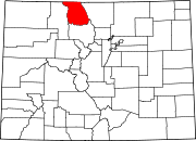
| County | Jackson County[1] |
| Elevation | 8,215 ft (2,504 m) |
| Time zone | UTC-7 (MST) |
| • Summer (DST) | UTC-6 (MDT) |
| ZIP Code[2] | 80480 |
Coalmont is an unincorporated community and U.S. Post Office in Jackson County, Colorado, United States. The town is named for the open-pit lignite coal mines in the area, from which coal was shipped out on the Union Pacific Railroad to the mainline at Laramie, Wyoming.
Geography[]
Coalmont is located at 40°33′43″N 106°26′44″W / 40.56194°N 106.44556°W (40.562069,-106.445675).
See also[]
- Outline of Colorado
- State of Colorado
- Colorado cities and towns
- Colorado counties
- North Park (Colorado basin)
References[]
- ^ a b "US Board on Geographic Names". United States Geological Survey. 2007-10-25. Retrieved 2008-01-31.
- ^ "United States Zip Codes". Retrieved December 21, 2021.
External links[]
| Wikimedia Commons has media related to Coalmont, Colorado. |
Categories:
- Unincorporated communities in Jackson County, Colorado
- Unincorporated communities in Colorado


