El Peñón Formation
| El Peñón Formation Stratigraphic range: Late Aptian ~ | |
|---|---|
| Type | Geological formation |
| Unit of | Villeta Group |
| Underlies | Capotes Formation |
| Overlies | Trincheras Formation |
| Thickness | more than 381 m (1,250 ft) |
| Lithology | |
| Primary | Calcareous shale |
| Other | Siltstone, gypsum |
| Location | |
| Coordinates | 5°15′13″N 74°20′28″W / 5.25361°N 74.34111°WCoordinates: 5°15′13″N 74°20′28″W / 5.25361°N 74.34111°W |
| Region | Altiplano Cundiboyacense Eastern Ranges, Andes |
| Country | |
| Type section | |
| Named for | El Peñón |
| Named by | Ulloa |
| Location | El Peñón |
| Year defined | 1982 |
| Coordinates | 5°15′13″N 74°20′28″W / 5.25361°N 74.34111°W |
| Region | Cundinamarca |
| Country | |
| Thickness at type section | 381 m (1,250 ft) |
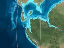 Paleogeography of Northern South America 120 Ma, by Ron Blakey | |

The El Peñón Formation (Spanish: Formación El Peñón, Kipe) is a geological formation of the Altiplano Cundiboyacense, Eastern Ranges of the Colombian Andes. The formation consists of calcareous shales and siltstones and dates to the Early Cretaceous period; Late Aptian epoch and has a measured thickness at its type section of 381 metres (1,250 ft). Ammonite fossils have been found in the formation, deposited in a shallow marine platform environment.
Etymology[]
The formation was defined and named in 1982 by Ulloa after El Peñón, Cundinamarca.[1]
Description[]
Lithologies[]
The El Peñón Formation has at is type section a thickness of 381 metres (1,250 ft),[2] and is characterised by a sequence of calcareous shales and siltstones. The middle part of the sequence contains gypsum.[3] Fossils of the ammonites and have been found in the El Peñón Formation.[1]
Stratigraphy and depositional environment[]
The El Peñón Formation, part of the Villeta Group, conformably overlies the Trincheras Formation and is conformably overlain by the Capotes Formation.[4] The age has been estimated to be Late Aptian.[1] Stratigraphically, the formation is time equivalent with the and a lateral facies equivalent of the Socotá Formation.[5] The formation has been deposited in a shallow marine platform environment.[1] In the Late Aptian, central Colombia was dominated by shallow marine carbonate platform environments.[6]
Outcrops[]

The El Peñón Formation, restricted to Cundinamarca, is locally found around its type locality,[1] between Bituima and Guayabal de Síquima,[7] and along the road from Villeta to Sasaima.[2]
Regional correlations[]
| Age | Paleomap | VMM | Guaduas-Vélez | W Emerald Belt | Villeta anticlinal | Chiquinquirá- Arcabuco |
Tunja- Duitama |
Altiplano Cundiboyacense | El Cocuy | ||||
|---|---|---|---|---|---|---|---|---|---|---|---|---|---|
| Maastrichtian |  |
eroded | Guaduas | ||||||||||
| Guadalupe | |||||||||||||
| Campanian | |||||||||||||
| Oliní | |||||||||||||
| Santonian | - | ||||||||||||
| Coniacian | Oliní | Conejo | Chipaque | ||||||||||
| Loma Gorda | undefined | La Frontera | |||||||||||
| Turonian |  |
Hondita | La Frontera | ||||||||||
| Cenomanian | hiatus | Simijaca | |||||||||||
| Pacho Fm. | Hiló - Pacho | Une | |||||||||||
| Albian |  |
Hiló | Une | ||||||||||
| Capotes - - | |||||||||||||
| Aptian | Capotes | Socotá - El Peñón | Paja | Fómeque | |||||||||
| Paja | Paja | El Peñón | Trincheras | ||||||||||
| La Naveta | |||||||||||||
| Barremian | 
| ||||||||||||
| Hauterivian | Las Juntas | ||||||||||||
| Rosablanca | Ritoque | ||||||||||||
| Valanginian | Ritoque | - Murca | Rosablanca | hiatus | Macanal | ||||||||
| Rosablanca | |||||||||||||
| Berriasian |  |
Guavio | |||||||||||
| Arcabuco | |||||||||||||
| Sources | |||||||||||||
See also[]
 Geology of the Eastern Hills
 Geology of the Ocetá Páramo
 Geology of the Altiplano Cundiboyacense
References[]
Bibliography[]
- , and . 2002. Mapa Geológico del Departamento de Cundinamarca - 1:250,000 - Memoria explicativa, 1–108. INGEOMINAS. Accessed 2017-04-26.
- , and . 2001. Geología de la Plancha 208 Villeta - 1:100,000, 1-84. INGEOMINAS. Accessed 2017-06-05.
- . 2012. Chronology Relative Sea Level History and a New Sequence Stratigraphic Model for Basinal Cretaceous Facies of Colombia, 161–216. Society for Sedimentary Geology (SEPM).
Maps[]
- , and . 1998. Plancha 208 - Villeta - 1:100,000, 1. INGEOMINAS. Accessed 2017-06-06.
- ; , and . 1998. Plancha 227 - La Mesa - 1:100,000, 1. INGEOMINAS. Accessed 2017-06-06.
External links[]
- ; ; , and . 2015. Plancha 5-09 del Atlas Geológico de Colombia 2015 – escala 1:500,000, 1. Servicio Geológico Colombiano. Accessed 2017-03-16.
- Geologic formations of Colombia
- Cretaceous Colombia
- Lower Cretaceous Series of South America
- Aptian Stage
- Shale formations
- Shallow marine deposits
- Altiplano Cundiboyacense
- Geography of Cundinamarca Department