Chipaque Formation
| Chipaque Formation Stratigraphic range: Cenomanian-Turonian ~ | |
|---|---|
| Type | Geological formation |
| Unit of | Villeta Group |
| Underlies | Guadalupe Gp |
| Overlies | Une Formation |
| Thickness | up to 1,700 metres (5,580 ft) |
| Lithology | |
| Primary | |
| Other | Sandstone, limestone, siltstone |
| Location | |
| Coordinates | 4°27′07″N 74°03′20″W / 4.45194°N 74.05556°WCoordinates: 4°27′07″N 74°03′20″W / 4.45194°N 74.05556°W |
| Region | Altiplano Cundiboyacense Eastern Ranges, Andes |
| Country | |
| Type section | |
| Named for | Chipaque |
| Named by | |
| Location | Chipaque |
| Year defined | 1957 |
| Coordinates | 4°27′07″N 74°03′20″W / 4.45194°N 74.05556°W |
| Region | Cundinamarca, Boyacá |
| Country | |
| Thickness at type section | 1,027 metres (3,370 ft) |
 Paleogeography of Northern South America 90 Ma, by Ron Blakey | |
The Chipaque Formation (Spanish: Formación Chipaque, K2cp, Kc) is a geological formation of the Altiplano Cundiboyacense, Eastern Ranges of the Colombian Andes. The formation is also described as Gachetá Formation, named after Gachetá, in the area of the Llanos foothills of the Eastern Ranges. The predominantly formation dates to the Late Cretaceous period; Cenomanian-Turonian epochs and has a maximum thickness of 1,700 metres (5,600 ft). The formation, rich in TOC, is an important oil and gas generating unit for the giant oilfields and of the Eastern Ranges as well as in the Llanos Orientales.
Etymology[]
The formation was named in 1931 as group and as formation in 1957 by after Chipaque, Cundinamarca.[1]
Description[]
Lithologies[]
The Chipaque Formation with a maximum thickness of 1,700 metres (5,600 ft), is characterised by a sequence of pyritic , limestones and siltstones, with sandstone banks intercalated in the formation.[2] The Chipaque Formation contains a high density of fauna.[1] The formation is rich in TOC and one of the principal source rocks for oil and gas generation in the foothills of the Eastern Ranges,[3] sourcing fields as , and many others.[4] Chipaque also sourced the oilfields of the Llanos Orientales.[5] In the Chitasugá-1 well, drilled between 1980 and 1981, from the sandstones of the Chipaque Formation half a million m³ of water were produced.[6] The sandstone beds are reservoir rocks for oil in the Eastern Ranges.[3]
Stratigraphy and depositional environment[]
The Chipaque Formation overlies the Une Formation and is overlain by the Guadalupe Group. The core of the Zipaquirá Anticline consists of the Chipaque Formation.[7] The age has been estimated to be Cenomanian-Turonian.[1] Stratigraphically, the formation is time equivalent with the Simijaca Formation.[8] The formation has been deposited in an to shallow marine platform setting.[9] The deposition is represented by a maximum flooding surface and anoxic conditions.[10]
Outcrops[]

The Chipaque Formation is apart from its type locality, found in the Eastern Hills of Bogotá, the Ocetá Páramo and many other locations in the Eastern Ranges. The anticlinals of the Río Blanco-Machetá, San José and Sopó-Sesquilé are composed of the Chipaque Formation.[1]
Regional correlations[]
| Age | Paleomap | VMM | Guaduas-Vélez | W Emerald Belt | Villeta anticlinal | Chiquinquirá- Arcabuco |
Tunja- Duitama |
Altiplano Cundiboyacense | El Cocuy | ||||
|---|---|---|---|---|---|---|---|---|---|---|---|---|---|
| Maastrichtian |  |
eroded | Guaduas | ||||||||||
| Guadalupe | |||||||||||||
| Campanian | |||||||||||||
| Oliní | |||||||||||||
| Santonian | - | ||||||||||||
| Coniacian | Oliní | Conejo | Chipaque | ||||||||||
| Loma Gorda | undefined | La Frontera | |||||||||||
| Turonian |  |
Hondita | La Frontera | ||||||||||
| Cenomanian | hiatus | Simijaca | |||||||||||
| Pacho Fm. | Hiló - Pacho | Une | |||||||||||
| Albian |  |
Hiló | Une | ||||||||||
| Capotes - - | |||||||||||||
| Aptian | Capotes | Socotá - El Peñón | Paja | Fómeque | |||||||||
| Paja | Paja | El Peñón | Trincheras | ||||||||||
| La Naveta | |||||||||||||
| Barremian | 
| ||||||||||||
| Hauterivian | Las Juntas | ||||||||||||
| Rosablanca | Ritoque | ||||||||||||
| Valanginian | Ritoque | - Murca | Rosablanca | hiatus | Macanal | ||||||||
| Rosablanca | |||||||||||||
| Berriasian |  |
Guavio | |||||||||||
| Arcabuco | |||||||||||||
| Sources | |||||||||||||
| Ma | Age | Paleomap | Regional events | proximal Llanos | distal Llanos | Environments | Maximum thickness | Petroleum geology | Notes | ||||
|---|---|---|---|---|---|---|---|---|---|---|---|---|---|
| 0.01 | Holocene |  |
Holocene volcanism Seismic activity |
alluvium | Overburden | ||||||||
| 1 | Pleistocene |  |
Pleistocene volcanism Andean orogeny 3 Glaciations |
Soatá Sabana |
Alluvial to fluvial (Guayabo) | 550 m (1,800 ft) (Guayabo) |
[11][12][13][14] | ||||||
| 2.6 | Pliocene |  |
Pliocene volcanism Andean orogeny 3 GABI |
Subachoque | |||||||||
| 5.3 | Messinian | Andean orogeny 3 Foreland |
Marichuela | Honda | [13][15] | ||||||||
| 13.5 | Langhian | Regional flooding | hiatus | Lacustrine (León) | 400 m (1,300 ft) (León) |
Seal | [14][16] | ||||||
| 16.2 | Burdigalian | Miocene inundations Andean orogeny 2 |
Proximal fluvio-deltaic (C1) | 850 m (2,790 ft) (Carbonera) |
Reservoir | [15][14] | |||||||
| 17.3 | Distal lacustrine-deltaic (C2) | Seal | |||||||||||
| 19 | Proximal fluvio-deltaic (C3) | Reservoir | |||||||||||
| 21 | Early Miocene | Pebas wetlands | Barzalosa | Distal fluvio-deltaic (C4) | Seal | ||||||||
| 23 | Late Oligocene |  |
Andean orogeny 1 Foredeep |
Proximal fluvio-deltaic (C5) | Reservoir | [12][15] | |||||||
| 25 | Distal fluvio-lacustrine (C6) | Seal | |||||||||||
| 28 | Early Oligocene | Proximal deltaic-marine (C7) | Reservoir | [12][15][17] | |||||||||
| 32 | Oligo-Eocene | Usme | onlap | Marine-deltaic (C8) | Seal Source |
[17] | |||||||
| 35 | Late Eocene |  |
Coastal (Mirador) | 240 m (790 ft) (Mirador) |
Reservoir | [14][18] | |||||||
| 40 | Middle Eocene | Regadera | hiatus | ||||||||||
| 45 | |||||||||||||
| 50 | Early Eocene | |
Deltaic (Los Cuervos) | 260 m (850 ft) (Los Cuervos) |
Seal Source |
[14][18] | |||||||
| 55 | Late Paleocene | PETM 2000 ppm CO2 |
Bogotá | ||||||||||
| 60 | Early Paleocene | SALMA | Barco | Guaduas | Fluvial (Barco) | 225 m (738 ft) (Barco) |
Reservoir | [11][12][15][14][19] | |||||
| 65 | Maastrichtian | |
KT extinction | Guadalupe | Deltaic-fluvial (Guadalupe) | 750 m (2,460 ft) (Guadalupe) |
Reservoir | [11][14] | |||||
| 72 | Campanian | End of rifting | [14][20] | ||||||||||
| 83 | Santonian | Villeta/Güagüaquí | |||||||||||
| 86 | Coniacian | ||||||||||||
| 89 | Turonian | Cenomanian-Turonian anoxic event | Chipaque | Gachetá | hiatus | Restricted marine (all) | 500 m (1,600 ft) (Gachetá) |
Source | [11][14][21] | ||||
| 93 | Cenomanian | |
Rift 2 | ||||||||||
| 100 | Albian | Une | Une | Caballos | Deltaic (Une) | 500 m (1,600 ft) (Une) |
Reservoir | [15][21] | |||||
| 113 | Aptian | |
Fómeque | Open marine (Fómeque) | 800 m (2,600 ft) (Fómeque) |
Source (Fóm) | [12][14][22] | ||||||
| 125 | Barremian | High biodiversity | Paja | Shallow to open marine (Paja) | 940 m (3,080 ft) (Paja) |
Reservoir | [11] | ||||||
| 129 | Hauterivian | |
Rift 1 | Las Juntas | hiatus | Deltaic (Las Juntas) | 910 m (2,990 ft) (Las Juntas) |
Reservoir (LJun) | [11] | ||||
| 133 | Valanginian | Macanal Rosablanca |
Restricted marine (Macanal) | 2,935 m (9,629 ft) (Macanal) |
Source (Mac) | [12][23] | |||||||
| 140 | Berriasian | Girón | |||||||||||
| 145 | Tithonian | Break-up of Pangea | Arcabuco | Alluvial, fluvial (Buenavista) | 110 m (360 ft) (Buenavista) |
"Jurassic" | [15][24] | ||||||
| 150 | Early-Mid Jurassic |  |
Passive margin 2 | La Quinta | Noreán |
hiatus | Coastal tuff (La Quinta) | 100 m (330 ft) (La Quinta) |
[25] | ||||
| 201 | Late Triassic |  |
[15] | ||||||||||
| 235 | Early Triassic |  |
Pangea | hiatus | "Paleozoic" | ||||||||
| 250 | Permian |  |
|||||||||||
| 300 | Late Carboniferous | 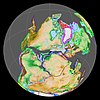 |
Famatinian orogeny | () |
[26] | ||||||||
| 340 | Early Carboniferous | Fossil fish Romer's gap |
Cuche (355-385) |
() |
Deltaic, estuarine (Cuche) | 900 m (3,000 ft) (Cuche) |
|||||||
| 360 | Late Devonian |  |
Passive margin 1 | Río Cachirí (360-419) |
() |
Alluvial-fluvial-reef (Farallones) | 2,400 m (7,900 ft) (Farallones) |
[23][27][28][29][30] | |||||
| 390 | Early Devonian |  |
High biodiversity | Floresta (387-400) |
Shallow marine (Floresta) | 600 m (2,000 ft) (Floresta) |
|||||||
| 410 | Late Silurian | ||||||||||||
| 425 | Early Silurian | hiatus | |||||||||||
| 440 | Late Ordovician |  |
Rich fauna in Bolivia | (450-490) |
() |
||||||||
| 470 | Early Ordovician | First fossils | (>470±22) |
() |
() |
() |
[31][32][33] | ||||||
| 488 | Late Cambrian |  |
Regional intrusions | (490-515) |
() |
() |
(490-590) |
() |
[34][35] | ||||
| 515 | Early Cambrian | Cambrian explosion | [33][36] | ||||||||||
| 542 | Ediacaran |  |
Break-up of Rodinia | pre-Quetame | post-Parguaza | () |
Yellow: allochthonous basement (Chibcha Terrane) Green: autochthonous basement (Río Negro-Juruena Province) |
Basement | [37][38] | ||||
| 600 | Neoproterozoic |  |
Cariri Velhos orogeny | (600-1400) |
pre-Guaviare | [34] | |||||||
| 800 |  |
Snowball Earth | [39] | ||||||||||
| 1000 | Mesoproterozoic |  |
Sunsás orogeny | (1000) |
(1030-1100) |
[40][41][42][43] | |||||||
| 1300 | pre-Ariarí | (1300-1400) |
(1180-1550) |
[44] | |||||||||
| 1400 |  |
pre-Bucaramanga | [45] | ||||||||||
| 1600 | Paleoproterozoic | (1500-1700) |
pre-Garzón | [46] | |||||||||
| 1800 |  |
(1800) |
[44][46] | ||||||||||
| 1950 | pre-Mitú | [44] | |||||||||||
| 2200 | Columbia | ||||||||||||
| 2530 | Archean |  |
[44] | ||||||||||
| 3100 | Kenorland | ||||||||||||
| Sources | |||||||||||||
- Legend
- group
- important formation
- fossiliferous formation
- minor formation
- (age in Ma)
- proximal Llanos (Medina)[note 1]
- distal Llanos (Saltarin 1A well)[note 2]
Gallery[]
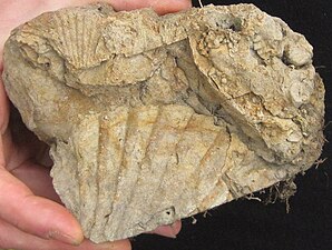
Oyster fossils from a sandstone bank of the Chipaque Formation

Organic shale of the Chipaque Formation

Chipaque Formation
Ocetá Páramo
Chipaque Formation
Ocetá Páramo
Banded shale of the Chipaque Formation
Ocetá Páramo


See also[]
- Geology of the Eastern Hills
- Geology of the Ocetá Páramo
- Geology of the Altiplano Cundiboyacense
- Petroleum industry in Colombia
Notes and references[]
Notes[]
References[]
- ^ a b c d Montoya Arenas & Reyes Torres, 2005, p.26
- ^ Lobo Guerrero, 1992, p.4
- ^ a b García González et al., 2009, p.49
- ^ Cortés et al., 2009, p.4
- ^ García González et al., 2009, p.58
- ^ Lobo Guerrero, 1993, p.20
- ^ García & Jiménez, 2016, p.24
- ^ Montoya Arenas & Reyes Torres, 2005, p.22
- ^ García González et al., 2009, p.209
- ^ Villamil, 2012, p.164
- ^ a b c d e f García González et al., 2009, p.27
- ^ a b c d e f García González et al., 2009, p.50
- ^ a b García González et al., 2009, p.85
- ^ a b c d e f g h i j Barrero et al., 2007, p.60
- ^ a b c d e f g h Barrero et al., 2007, p.58
- ^ Plancha 111, 2001, p.29
- ^ a b Plancha 177, 2015, p.39
- ^ a b Plancha 111, 2001, p.26
- ^ Plancha 111, 2001, p.24
- ^ Plancha 111, 2001, p.23
- ^ a b Pulido & Gómez, 2001, p.32
- ^ Pulido & Gómez, 2001, p.30
- ^ a b Pulido & Gómez, 2001, pp.21-26
- ^ Pulido & Gómez, 2001, p.28
- ^ Correa Martínez et al., 2019, p.49
- ^ Plancha 303, 2002, p.27
- ^ Terraza et al., 2008, p.22
- ^ Plancha 229, 2015, pp.46-55
- ^ Plancha 303, 2002, p.26
- ^ Moreno Sánchez et al., 2009, p.53
- ^ Mantilla Figueroa et al., 2015, p.43
- ^ Manosalva Sánchez et al., 2017, p.84
- ^ a b Plancha 303, 2002, p.24
- ^ a b Mantilla Figueroa et al., 2015, p.42
- ^ Arango Mejía et al., 2012, p.25
- ^ Plancha 350, 2011, p.49
- ^ Pulido & Gómez, 2001, pp.17-21
- ^ Plancha 111, 2001, p.13
- ^ Plancha 303, 2002, p.23
- ^ Plancha 348, 2015, p.38
- ^ Planchas 367-414, 2003, p.35
- ^ Toro Toro et al., 2014, p.22
- ^ Plancha 303, 2002, p.21
- ^ a b c d Bonilla et al., 2016, p.19
- ^ Gómez Tapias et al., 2015, p.209
- ^ a b Bonilla et al., 2016, p.22
- ^ a b Duarte et al., 2019
- ^ García González et al., 2009
- ^ Pulido & Gómez, 2001
- ^ García González et al., 2009, p.60
Bibliography[]
- , and . 2016. Structural analysis of the Zipaquirá Anticline (Eastern Cordillera, Colombia). , Universidad Nacional de Colombia 39. 21–32.
- . 2012. Combined structural and Petroleum Systems Modeling in the Eastern Cordillera Basin, Colombia (MSc. thesis), 1–161. Rheinisch-Westfälische Technische Hochschule Aachen & .
- . 2012. Chronology Relative Sea Level History and a New Sequence Stratigraphic Model for Basinal Cretaceous Facies of Colombia, 161–216. Society for Sedimentary Geology (SEPM).
- ; ; , and . 2009. Timing of oil generation in the Eastern flank of the Eastern Cordillera of Colombia based on kinematic models; implications in the Llanos Foothills and Foreland charge, 1–8. (ACGGP).
- ; ; , and . 2009. Informe Ejecutivo - evaluación del potencial hidrocarburífero de las cuencas colombianas, 1–219. Universidad Industrial de Santander.
- , and . 2005. Geología de la Sabana de Bogotá, 1–104. INGEOMINAS.
- . 1993. Informe sobre la Cuenca Petrolífera de la Sabana de Bogotá, Colombia, 1–29.
- . 1992. Geología e Hidrogeología de Santafé de Bogotá y su Sabana, 1–20. Sociedad Colombiana de Ingenieros.
Reports[]
- ; ; ; ; ; , and . 2008. Geología del cinturón esmeraldífero oriental Planchas 210, 228, 229, 1−126. INGEOMINAS.
- , and . 2001. Geología de la Plancha 227 - La Mesa - 1:100,000, 1–80. INGEOMINAS.
- ; ; ; ; ; ; ; , and . 2013. Geología de la Plancha 229 - Gachalá - 1:100,000, 1–296. Servicio Geológico Colombiano. Accessed 2018-06-01.
- ; ; ; ; ; ; ; , and . 2011. Cartografía geológica de la Plancha 247 - Cáqueza - 1:100,000, 1–100. INGEOMINAS. Accessed 2017-08-04.
Maps[]
- ; , and . 1998. Plancha 172 - Paz de Río - 1:100,000, 1. INGEOMINAS. Accessed 2017-06-06.
- ; , and . 1998. Plancha 192 - Laguna de Tota - 1:100,000, 1. INGEOMINAS. Accessed 2017-06-06.
- . 1992. Plancha 193 - Yopal - 1:100,000, 1. INGEOMINAS. Accessed 2017-06-06.
- , and . 2009. Plancha 209 - Zipaquirá - 1:100,000, 1. INGEOMINAS. Accessed 2017-06-06.
- ; ; ; , and . 2010. Plancha 210 - Guateque - 1:100,000, 1. INGEOMINAS. Accessed 2017-06-06.
- , and . 2009. Plancha 211 - Tauramena - 1:100,000, 1. INGEOMINAS. Accessed 2017-06-06.
- ; , and . 1998. Plancha 228 - Santafé de Bogotá Noreste - 1:100,000, 1. INGEOMINAS. Accessed 2017-06-06.
- ; , and . 2009. Plancha 230 - Monterrey - 1:100,000, 1. INGEOMINAS. Accessed 2017-06-06.
- , and . 1998. Plancha 246 - Fusagasugá - 1:100,000, 1. INGEOMINAS. Accessed 2017-06-06.
- ; , and . 1999. Plancha 265 - Icononzo - 1:100,000, 1. INGEOMINAS. Accessed 2017-06-06.
- ; , and . 1998. Plancha 266 - Villavicencio - 1:100,000, 1. INGEOMINAS. Accessed 2017-06-06.
- ; ; , and . 2002. Plancha 303 - Colombia - 1:100,000, 1. INGEOMINAS.
- , and . 2005. Planchas 171 & 191 - Geología sector del sur del municipio de Paipa (Boyacá) - 1:25,000. INGEOMINAS.
- . 1997. Mapa geológico de Santa Fe de Bogotá – Geological Map Bogotá – 1:50,000, 1. INGEOMINAS. Accessed 2017-03-16.
External links[]
| Wikimedia Commons has media related to Chipaque Formation. |
- ; ; , and . 2015. Plancha 5-09 del Atlas Geológico de Colombia 2015 – escala 1:500,000, 1. Servicio Geológico Colombiano. Accessed 2017-03-16.
- Geologic formations of Colombia
- Cretaceous Colombia
- Upper Cretaceous Series of South America
- Cenomanian Stage
- Turonian Stage
- Shale formations
- Open marine deposits
- Shallow marine deposits
- Source rock formations
- Mining in Colombia
- Altiplano Cundiboyacense
- Geography of Cundinamarca Department
- Geography of Boyacá Department
- Geography of Bogotá
- Muysccubun