Floresta Formation
| Floresta Formation Stratigraphic range: Late Emsian-Early Givetian ~ | |
|---|---|
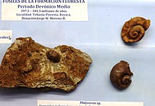 Platyceras nodosum from the Floresta Formation | |
| Type | Geological formation |
| Underlies | Cuche Formation |
| Overlies | |
| Thickness | up to 600 m (2,000 ft) |
| Lithology | |
| Primary | Siltstone |
| Other | Shale, coquina, sandstone |
| Location | |
| Coordinates | 5°51′37.2″N 72°56′57.6″W / 5.860333°N 72.949333°WCoordinates: 5°51′37.2″N 72°56′57.6″W / 5.860333°N 72.949333°W |
| Region | Altiplano Cundiboyacense Eastern Ranges, Andes |
| Country | |
| Type section | |
| Named for | Floresta |
| Named by | Olsson & Carter |
| Location | Floresta |
| Year defined | 1939 |
| Coordinates | 5°51′37.2″N 72°56′57.6″W / 5.860333°N 72.949333°W |
| Approximate paleocoordinates | 51°42′S 48°06′W / 51.7°S 48.1°W |
| Region | Boyacá |
| Country | |
| Thickness at type section | 600 m (2,000 ft) |
 Paleogeography of the Middle Devonian 380 Ma, by Stampfli & Borel | |
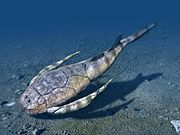
The Floresta Formation (Spanish: Formación Floresta, Df) is a geological formation of the Altiplano Cundiboyacense in the Eastern Ranges of the Colombian Andes. The sequence of siltstones, shales, coquinas and sandstone beds dates to the Devonian period; Late Emsian, Eifelian and Early Givetian epochs, and has a maximum thickness of 600 metres (2,000 ft). The unit is highly fossiliferous; brachiopods, bryozoans, gastropods, trilobites, corals and bivalves have been found in the Floresta Formation. Some fragments of Placoderm fish fossils were found in the Floresta Formation, while the overlying Cuche Formation is much richer in fish biodiversity.
Etymology[]
The formation was first described as Floresta Series by Olsson and Carter in 1939. The current definition was given by Botero in 1950. The formation is named after Floresta, Boyacá, where the formation outcrops.[1]
Description[]
Lithologies[]
The Floresta Formation is characterized by a lower sequence of shales and ochre to beige siltstones with alternating coquinas, while the upper part consists of siltstones with sandy beds.[2]
Stratigraphy and depositional environment[]
The Floresta Formation overlies the and is overlain by the Cuche Formation. The age has been estimated to be Late Emsian to Early Givetian.[3] Stratigraphically, the formation is time equivalent with the around Quetame.[4] The Onondaga Formation of New York is considered time equivalent too.[5] The formation contains concretions and a high diversity of fossils. The formation was deposited in a transgressional and regressional epicontinental marine environment at the edge of the Paleo-Tethys Ocean.[6] The uppermost part of the formation has been deposited in a deltaic setting,[7] with the lower sequence formed in a coral reef environment.[8]
Fossil content[]
Remains of ,[9] ,[10] Dipleura cf. dekayi, ,[11] , Cordania gasepiou, Viaphacops cristata,[12] Anchiopsis armata,[13] , Coronura cf. lessepsensis,[14] Greenops cf. grabaui,[15] , ,[16] Placoderm fishes,[17] Platyceras nodosum,[18] , , Atrypa harrisi, , Aviculopecten wellsi, , Camarotoechia dotis, Chonetes cf. billingsi, C. comstockii, C. cf. stubeli, , , , , , , , , , Cypricardinia cf. subindenta, , Dalmanites cf. patacamayaensis, , , , Favosites aff. hamiltonensis, , , , , , , , , Heliophyllum halli,[18] , , , Leptaena boyaca, , , , Meristella wheeleri, , Odontopleura callicera, , Phacops cf. salteri, , , Pleurodictyum americanum, , , , , , , , , Spirifer kingi, , , , , , , , , , , Anthozoa sp., Camarotoechia sp., , Cyphaspis sp., , Dalmanites sp., , Gastropoda sp., , Homalonotus sp., , , Orthoceras sp., Ostracoda sp., Orthis sp., Paraspirifer sp., Proetus sp., , , , and have been described from the Floresta Formation.[19] , and Tarijactinoides sp. nov.,[16] were newly described in 2015.[3]
Outcrops[]

The Floresta Formation is found at the Floresta Massif around its type locality in Floresta, Boyacá,[20] stretching to the south until between Busbanzá and Nobsa and to the west close to Belén, Cerinza and Tutazá.[21] The formation is also found in the upper course of the Chicamocha River in the eponymous canyon.
Many of the fossils are on display in the paleontological museum of Floresta.
Regional correlations[]
| Ma | Age | Paleomap | Regional events | proximal Llanos | distal Llanos | Environments | Maximum thickness | Petroleum geology | Notes | ||||
|---|---|---|---|---|---|---|---|---|---|---|---|---|---|
| 0.01 | Holocene |  |
Holocene volcanism Seismic activity |
alluvium | Overburden | ||||||||
| 1 | Pleistocene |  |
Pleistocene volcanism Andean orogeny 3 Glaciations |
Soatá Sabana |
Alluvial to fluvial (Guayabo) | 550 m (1,800 ft) (Guayabo) |
[22][23][24][25] | ||||||
| 2.6 | Pliocene |  |
Pliocene volcanism Andean orogeny 3 GABI |
Subachoque | |||||||||
| 5.3 | Messinian | Andean orogeny 3 Foreland |
Marichuela | Honda | [24][26] | ||||||||
| 13.5 | Langhian | Regional flooding | hiatus | Lacustrine (León) | 400 m (1,300 ft) (León) |
Seal | [25][27] | ||||||
| 16.2 | Burdigalian | Miocene inundations Andean orogeny 2 |
Proximal fluvio-deltaic (C1) | 850 m (2,790 ft) (Carbonera) |
Reservoir | [26][25] | |||||||
| 17.3 | Distal lacustrine-deltaic (C2) | Seal | |||||||||||
| 19 | Proximal fluvio-deltaic (C3) | Reservoir | |||||||||||
| 21 | Early Miocene | Pebas wetlands | Barzalosa | Distal fluvio-deltaic (C4) | Seal | ||||||||
| 23 | Late Oligocene |  |
Andean orogeny 1 Foredeep |
Proximal fluvio-deltaic (C5) | Reservoir | [23][26] | |||||||
| 25 | Distal fluvio-lacustrine (C6) | Seal | |||||||||||
| 28 | Early Oligocene | Proximal deltaic-marine (C7) | Reservoir | [23][26][28] | |||||||||
| 32 | Oligo-Eocene | Usme | onlap | Marine-deltaic (C8) | Seal Source |
[28] | |||||||
| 35 | Late Eocene |  |
Coastal (Mirador) | 240 m (790 ft) (Mirador) |
Reservoir | [25][29] | |||||||
| 40 | Middle Eocene | Regadera | hiatus | ||||||||||
| 45 | |||||||||||||
| 50 | Early Eocene |  |
Deltaic (Los Cuervos) | 260 m (850 ft) (Los Cuervos) |
Seal Source |
[25][29] | |||||||
| 55 | Late Paleocene | PETM 2000 ppm CO2 |
Bogotá | ||||||||||
| 60 | Early Paleocene | SALMA | Barco | Guaduas | Fluvial (Barco) | 225 m (738 ft) (Barco) |
Reservoir | [22][23][26][25][30] | |||||
| 65 | Maastrichtian |  |
KT extinction | Guadalupe | Deltaic-fluvial (Guadalupe) | 750 m (2,460 ft) (Guadalupe) |
Reservoir | [22][25] | |||||
| 72 | Campanian | End of rifting | [25][31] | ||||||||||
| 83 | Santonian | Villeta/Güagüaquí | |||||||||||
| 86 | Coniacian | ||||||||||||
| 89 | Turonian | Cenomanian-Turonian anoxic event | Chipaque | Gachetá | hiatus | Restricted marine (all) | 500 m (1,600 ft) (Gachetá) |
Source | [22][25][32] | ||||
| 93 | Cenomanian |  |
Rift 2 | ||||||||||
| 100 | Albian | Une | Une | Caballos | Deltaic (Une) | 500 m (1,600 ft) (Une) |
Reservoir | [26][32] | |||||
| 113 | Aptian |  |
Fómeque | Open marine (Fómeque) | 800 m (2,600 ft) (Fómeque) |
Source (Fóm) | [23][25][33] | ||||||
| 125 | Barremian | High biodiversity | Paja | Shallow to open marine (Paja) | 940 m (3,080 ft) (Paja) |
Reservoir | [22] | ||||||
| 129 | Hauterivian |  |
Rift 1 | Las Juntas | hiatus | Deltaic (Las Juntas) | 910 m (2,990 ft) (Las Juntas) |
Reservoir (LJun) | [22] | ||||
| 133 | Valanginian | Macanal Rosablanca |
Restricted marine (Macanal) | 2,935 m (9,629 ft) (Macanal) |
Source (Mac) | [23][34] | |||||||
| 140 | Berriasian | Girón | |||||||||||
| 145 | Tithonian | Break-up of Pangea | Arcabuco | Alluvial, fluvial (Buenavista) | 110 m (360 ft) (Buenavista) |
"Jurassic" | [26][35] | ||||||
| 150 | Early-Mid Jurassic |  |
Passive margin 2 | La Quinta | Noreán |
hiatus | Coastal tuff (La Quinta) | 100 m (330 ft) (La Quinta) |
[36] | ||||
| 201 | Late Triassic |  |
[26] | ||||||||||
| 235 | Early Triassic |  |
Pangea | hiatus | "Paleozoic" | ||||||||
| 250 | Permian |  |
|||||||||||
| 300 | Late Carboniferous | 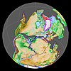 |
Famatinian orogeny | () |
[37] | ||||||||
| 340 | Early Carboniferous | Fossil fish Romer's gap |
Cuche (355-385) |
() |
Deltaic, estuarine (Cuche) | 900 m (3,000 ft) (Cuche) |
|||||||
| 360 | Late Devonian |  |
Passive margin 1 | Río Cachirí (360-419) |
() |
Alluvial-fluvial-reef (Farallones) | 2,400 m (7,900 ft) (Farallones) |
[34][38][39][40][41] | |||||
| 390 | Early Devonian |  |
High biodiversity | Floresta (387-400) |
Shallow marine (Floresta) | 600 m (2,000 ft) (Floresta) |
|||||||
| 410 | Late Silurian | ||||||||||||
| 425 | Early Silurian | hiatus | |||||||||||
| 440 | Late Ordovician |  |
Rich fauna in Bolivia | (450-490) |
() |
||||||||
| 470 | Early Ordovician | First fossils | (>470±22) |
() |
() |
() |
[42][43][44] | ||||||
| 488 | Late Cambrian |  |
Regional intrusions | (490-515) |
() |
() |
(490-590) |
() |
[45][46] | ||||
| 515 | Early Cambrian | Cambrian explosion | [44][47] | ||||||||||
| 542 | Ediacaran |  |
Break-up of Rodinia | pre-Quetame | post-Parguaza | () |
Yellow: allochthonous basement (Chibcha Terrane) Green: autochthonous basement (Río Negro-Juruena Province) |
Basement | [48][49] | ||||
| 600 | Neoproterozoic |  |
Cariri Velhos orogeny | (600-1400) |
pre-Guaviare | [45] | |||||||
| 800 |  |
Snowball Earth | [50] | ||||||||||
| 1000 | Mesoproterozoic |  |
Sunsás orogeny | (1000) |
(1030-1100) |
[51][52][53][54] | |||||||
| 1300 | pre-Ariarí | (1300-1400) |
(1180-1550) |
[55] | |||||||||
| 1400 |  |
pre-Bucaramanga | [56] | ||||||||||
| 1600 | Paleoproterozoic | (1500-1700) |
pre-Garzón | [57] | |||||||||
| 1800 |  |
(1800) |
[55][57] | ||||||||||
| 1950 | pre-Mitú | [55] | |||||||||||
| 2200 | Columbia | ||||||||||||
| 2530 | Archean |  |
[55] | ||||||||||
| 3100 | Kenorland | ||||||||||||
| Sources | |||||||||||||
- Legend
- group
- important formation
- fossiliferous formation
- minor formation
- (age in Ma)
- proximal Llanos (Medina)[note 1]
- distal Llanos (Saltarin 1A well)[note 2]
See also[]
 Geology of the Eastern Hills
 Geology of the Ocetá Páramo
 Geology of the Altiplano Cundiboyacense
Notes[]
References[]
- ^ Mojica & Villarroel, 1984, p.64
- ^ Morzadec et al., 2015, p.332
- ^ a b Morzadec et al., 2015, p.355
- ^ Morzadec et al., 2015, p.331
- ^ Giroud López, 2014, p.168
- ^ Janvier & Villarroel, 1998, p.6
- ^ Giroud López, 2014, p.169
- ^ Giroud López, 2014, p.170
- ^ Morzadec et al., 2015, p.335
- ^ Morzadec et al., 2015, p.336
- ^ Morzadec et al., 2015, p.340
- ^ Morzadec et al., 2015, p.342
- ^ Morzadec et al., 2015, p.344
- ^ Morzadec et al., 2015, p.346
- ^ Morzadec et al., 2015, p.348
- ^ a b Morzadec et al., 2015, p.352
- ^ Janvier & Villarroel, 1998, p.9
- ^ a b Giroud López, 2014, p.39
- ^ Floresta at Fossilworks.org
- ^ Mojica & Villarroel, 1984, p.70
- ^ Plancha 172, 1998
- ^ a b c d e f García González et al., 2009, p.27
- ^ a b c d e f García González et al., 2009, p.50
- ^ a b García González et al., 2009, p.85
- ^ a b c d e f g h i j Barrero et al., 2007, p.60
- ^ a b c d e f g h Barrero et al., 2007, p.58
- ^ Plancha 111, 2001, p.29
- ^ a b Plancha 177, 2015, p.39
- ^ a b Plancha 111, 2001, p.26
- ^ Plancha 111, 2001, p.24
- ^ Plancha 111, 2001, p.23
- ^ a b Pulido & Gómez, 2001, p.32
- ^ Pulido & Gómez, 2001, p.30
- ^ a b Pulido & Gómez, 2001, pp.21-26
- ^ Pulido & Gómez, 2001, p.28
- ^ Correa Martínez et al., 2019, p.49
- ^ Plancha 303, 2002, p.27
- ^ Terraza et al., 2008, p.22
- ^ Plancha 229, 2015, pp.46-55
- ^ Plancha 303, 2002, p.26
- ^ Moreno Sánchez et al., 2009, p.53
- ^ Mantilla Figueroa et al., 2015, p.43
- ^ Manosalva Sánchez et al., 2017, p.84
- ^ a b Plancha 303, 2002, p.24
- ^ a b Mantilla Figueroa et al., 2015, p.42
- ^ Arango Mejía et al., 2012, p.25
- ^ Plancha 350, 2011, p.49
- ^ Pulido & Gómez, 2001, pp.17-21
- ^ Plancha 111, 2001, p.13
- ^ Plancha 303, 2002, p.23
- ^ Plancha 348, 2015, p.38
- ^ Planchas 367-414, 2003, p.35
- ^ Toro Toro et al., 2014, p.22
- ^ Plancha 303, 2002, p.21
- ^ a b c d Bonilla et al., 2016, p.19
- ^ Gómez Tapias et al., 2015, p.209
- ^ a b Bonilla et al., 2016, p.22
- ^ a b Duarte et al., 2019
- ^ García González et al., 2009
- ^ Pulido & Gómez, 2001
- ^ García González et al., 2009, p.60
Bibliography[]
- . 2014. El Mar en la Localidad Tipo del Devónico Medio, del Municipio de Floresta - Boyacá, Colombia, 1-174. Universidad de La Habana. Accessed 2017-03-31.
- , and . 1998. Los Peces Devónicos del Macizo de Floresta (Boyacá, Colombia). Consideraciones taxonómicas, bioestratigráficas, biogeográficas y ambientales. 23. 3-18. Accessed 2017-03-31.
- , and . 1984. Contribución al conocimiento de las unidades paleozoicas del área de Floresta (Cordillera Oriental Colombiana; Departamento de Boyacá) y en especial al de la Formación Cuche. 13. 55-80. Accessed 2017-03-31.
- ; ; ; , and . 2015. Trilobites and inarticulate brachiopods from the Devonian Floresta Formation of Colombia: a review. Bulletin of Geosciences 90. 331-358. Accessed 2017-04-04.
Maps[]
- ; ; ; , and . 1999. Plancha 111 - Toledo - 1:100,000, 1. INGEOMINAS. Accessed 2017-06-06.
- ; ; ; ; ; ; ; , and . 2009. Plancha 135 - San Gil - 1:100,000, 1. INGEOMINAS. Accessed 2017-06-06.
- ; ; , and . 1984. Plancha 136 - Málaga - 1:100,000, 1. INGEOMINAS. Accessed 2017-06-06.
- . 2009. Plancha 151 - Charalá - 1:100,000, 1. INGEOMINAS. Accessed 2017-06-06.
- ; , and . 1998. Plancha 172 - Paz de Río - 1:100,000, 1. INGEOMINAS. Accessed 2017-06-06.
External links[]
- (in Spanish) Peces devónicos de Colombia, diversidad en los mares y ríos de hace 410-355 millones de años
|     | ||||||||||||||||||||||||||
| Major fossiliferous stratigraphic units |
| ||||||||||||||||||||||||||
| |||||||||||||||||||||||||||
- Floresta Formation
- Geologic formations of Colombia
- Devonian System of South America
- Devonian Colombia
- Shale formations
- Deltaic deposits
- Reef deposits
- Geography of Boyacá Department