Caballos Formation
| Caballos Formation Stratigraphic range: Aptian-Albian ~ | |
|---|---|
| Type | Geological formation |
| Underlies | Hondita Formation |
| Overlies | & |
| Thickness | up to 411 m (1,348 ft) |
| Lithology | |
| Primary | Sandstone, shale, siltstone |
| Other | Limestone, coal |
| Location | |
| Coordinates | 3°49′18.9″N 75°21′22.4″W / 3.821917°N 75.356222°WCoordinates: 3°49′18.9″N 75°21′22.4″W / 3.821917°N 75.356222°W |
| Region | Caquetá, Huila, Putumayo & Tolima Departments |
| Country | |
| Extent | & Central & Eastern Ranges, Andes |
| Type section | |
| Named for | Cerro Caballos |
| Named by | Corrigan |
| Location | Olaya Herrera |
| Year defined | 1967 |
| Coordinates | 3°49′18.9″N 75°21′22.4″W / 3.821917°N 75.356222°W |
| Approximate paleocoordinates | 2°54′S 47°24′W / 2.9°S 47.4°W |
| Region | Tolima |
| Country | |
| Thickness at type section | 411 m (1,348 ft) |
 Paleogeography of Northern South America 105 Ma, by Ron Blakey | |

The Caballos Formation (Spanish: Formación Caballos, KI) is a geological formation of the (VSM), , Central and Eastern Ranges of the Colombian Andes. The sandstone and shale formation dates to the Middle Cretaceous period; Aptian to Albian epochs and has a maximum thickness of 411 metres (1,348 ft).
Etymology[]
The formation was defined and named in 1967 by Corrigan after Cerro Caballos, to the west of Olaya Herrera, Tolima.[1]
Description[]
Lithologies[]
The Caballos Formation has a maximum thickness of 411 metres (1,348 ft) in the Quebrada Bambucá and is characterized by a lower sequence of fine to coarse sandstones, of lithic arenite, quartz arenite and feldspar arenite composition, a middle section of fossiliferous black shales and siltstones, intercalated by micritic limestones and coals and very fine sandstones. The upper part of the formation contains conglomerates and glauconitic sandstones.[1]
Stratigraphy and depositional environment[]
The Caballos Formation in some parts concordantly overlies the and in other parts rests unconformably on the and .[2] The formation is overlain by the Hondita Formation. The age has been estimated to be Aptian to Albian. Stratigraphically, the formation is time equivalent with the Une, , Simijaca, El Peñón, Capotes, , and Pacho Formations.[3] The formation has been deposited in a fluvial to estuarine and shallow marine environment.[4]
The Caballos Formation is a source, reservoir and seal rock in the ,[5][6] and a source and reservoir rock in the .[7][8] The and of the latter basin produce from Caballos reservoirs.
Fossil content[]
The formation has provided fossils of Heminautilus etheringtoni,[9] Araucarites sp., Brachyphyllum sp., Cladophlebis sp., and Weichselia sp.,[10] as well as many types of pollen.[11]
Outcrops[]

The Caballos Formation is apart from its type locality, found in Huila, Tolima and Putumayo Departments.
Regional correlations[]
| Ma | Age | Paleomap | Regional events | proximal Llanos | distal Llanos | Environments | Maximum thickness | Petroleum geology | Notes | ||||
|---|---|---|---|---|---|---|---|---|---|---|---|---|---|
| 0.01 | Holocene |  |
Holocene volcanism Seismic activity |
alluvium | Overburden | ||||||||
| 1 | Pleistocene |  |
Pleistocene volcanism Andean orogeny 3 Glaciations |
Soatá Sabana |
Alluvial to fluvial (Guayabo) | 550 m (1,800 ft) (Guayabo) |
[12][13][14][15] | ||||||
| 2.6 | Pliocene |  |
Pliocene volcanism Andean orogeny 3 GABI |
Subachoque | |||||||||
| 5.3 | Messinian | Andean orogeny 3 Foreland |
Marichuela | Honda | [14][16] | ||||||||
| 13.5 | Langhian | Regional flooding | hiatus | Lacustrine (León) | 400 m (1,300 ft) (León) |
Seal | [15][17] | ||||||
| 16.2 | Burdigalian | Miocene inundations Andean orogeny 2 |
Proximal fluvio-deltaic (C1) | 850 m (2,790 ft) (Carbonera) |
Reservoir | [16][15] | |||||||
| 17.3 | Distal lacustrine-deltaic (C2) | Seal | |||||||||||
| 19 | Proximal fluvio-deltaic (C3) | Reservoir | |||||||||||
| 21 | Early Miocene | Pebas wetlands | Barzalosa | Distal fluvio-deltaic (C4) | Seal | ||||||||
| 23 | Late Oligocene |  |
Andean orogeny 1 Foredeep |
Proximal fluvio-deltaic (C5) | Reservoir | [13][16] | |||||||
| 25 | Distal fluvio-lacustrine (C6) | Seal | |||||||||||
| 28 | Early Oligocene | Proximal deltaic-marine (C7) | Reservoir | [13][16][18] | |||||||||
| 32 | Oligo-Eocene | Usme | onlap | Marine-deltaic (C8) | Seal Source |
[18] | |||||||
| 35 | Late Eocene |  |
Coastal (Mirador) | 240 m (790 ft) (Mirador) |
Reservoir | [15][19] | |||||||
| 40 | Middle Eocene | Regadera | hiatus | ||||||||||
| 45 | |||||||||||||
| 50 | Early Eocene |  |
Deltaic (Los Cuervos) | 260 m (850 ft) (Los Cuervos) |
Seal Source |
[15][19] | |||||||
| 55 | Late Paleocene | PETM 2000 ppm CO2 |
Bogotá | ||||||||||
| 60 | Early Paleocene | SALMA | Barco | Guaduas | Fluvial (Barco) | 225 m (738 ft) (Barco) |
Reservoir | [12][13][16][15][20] | |||||
| 65 | Maastrichtian |  |
KT extinction | Guadalupe | Deltaic-fluvial (Guadalupe) | 750 m (2,460 ft) (Guadalupe) |
Reservoir | [12][15] | |||||
| 72 | Campanian | End of rifting | [15][21] | ||||||||||
| 83 | Santonian | Villeta/Güagüaquí | |||||||||||
| 86 | Coniacian | ||||||||||||
| 89 | Turonian | Cenomanian-Turonian anoxic event | Chipaque | Gachetá | hiatus | Restricted marine (all) | 500 m (1,600 ft) (Gachetá) |
Source | [12][15][22] | ||||
| 93 | Cenomanian |  |
Rift 2 | ||||||||||
| 100 | Albian | Une | Une | Caballos | Deltaic (Une) | 500 m (1,600 ft) (Une) |
Reservoir | [16][22] | |||||
| 113 | Aptian |  |
Fómeque | Open marine (Fómeque) | 800 m (2,600 ft) (Fómeque) |
Source (Fóm) | [13][15][23] | ||||||
| 125 | Barremian | High biodiversity | Paja | Shallow to open marine (Paja) | 940 m (3,080 ft) (Paja) |
Reservoir | [12] | ||||||
| 129 | Hauterivian |  |
Rift 1 | Las Juntas | hiatus | Deltaic (Las Juntas) | 910 m (2,990 ft) (Las Juntas) |
Reservoir (LJun) | [12] | ||||
| 133 | Valanginian | Macanal Rosablanca |
Restricted marine (Macanal) | 2,935 m (9,629 ft) (Macanal) |
Source (Mac) | [13][24] | |||||||
| 140 | Berriasian | Girón | |||||||||||
| 145 | Tithonian | Break-up of Pangea | Arcabuco | Alluvial, fluvial (Buenavista) | 110 m (360 ft) (Buenavista) |
"Jurassic" | [16][25] | ||||||
| 150 | Early-Mid Jurassic |  |
Passive margin 2 | La Quinta | Noreán |
hiatus | Coastal tuff (La Quinta) | 100 m (330 ft) (La Quinta) |
[26] | ||||
| 201 | Late Triassic |  |
[16] | ||||||||||
| 235 | Early Triassic |  |
Pangea | hiatus | "Paleozoic" | ||||||||
| 250 | Permian |  |
|||||||||||
| 300 | Late Carboniferous | 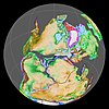 |
Famatinian orogeny | () |
[27] | ||||||||
| 340 | Early Carboniferous | Fossil fish Romer's gap |
Cuche (355-385) |
() |
Deltaic, estuarine (Cuche) | 900 m (3,000 ft) (Cuche) |
|||||||
| 360 | Late Devonian |  |
Passive margin 1 | Río Cachirí (360-419) |
() |
Alluvial-fluvial-reef (Farallones) | 2,400 m (7,900 ft) (Farallones) |
[24][28][29][30][31] | |||||
| 390 | Early Devonian |  |
High biodiversity | Floresta (387-400) |
Shallow marine (Floresta) | 600 m (2,000 ft) (Floresta) |
|||||||
| 410 | Late Silurian | ||||||||||||
| 425 | Early Silurian | hiatus | |||||||||||
| 440 | Late Ordovician |  |
Rich fauna in Bolivia | (450-490) |
() |
||||||||
| 470 | Early Ordovician | First fossils | (>470±22) |
() |
() |
() |
[32][33][34] | ||||||
| 488 | Late Cambrian |  |
Regional intrusions | (490-515) |
() |
() |
(490-590) |
() |
[35][36] | ||||
| 515 | Early Cambrian | Cambrian explosion | [34][37] | ||||||||||
| 542 | Ediacaran |  |
Break-up of Rodinia | pre-Quetame | post-Parguaza | () |
Yellow: allochthonous basement (Chibcha Terrane) Green: autochthonous basement (Río Negro-Juruena Province) |
Basement | [38][39] | ||||
| 600 | Neoproterozoic |  |
Cariri Velhos orogeny | (600-1400) |
pre-Guaviare | [35] | |||||||
| 800 |  |
Snowball Earth | [40] | ||||||||||
| 1000 | Mesoproterozoic |  |
Sunsás orogeny | (1000) |
(1030-1100) |
[41][42][43][44] | |||||||
| 1300 | pre-Ariarí | (1300-1400) |
(1180-1550) |
[45] | |||||||||
| 1400 |  |
pre-Bucaramanga | [46] | ||||||||||
| 1600 | Paleoproterozoic | (1500-1700) |
pre-Garzón | [47] | |||||||||
| 1800 |  |
(1800) |
[45][47] | ||||||||||
| 1950 | pre-Mitú | [45] | |||||||||||
| 2200 | Columbia | ||||||||||||
| 2530 | Archean |  |
[45] | ||||||||||
| 3100 | Kenorland | ||||||||||||
| Sources | |||||||||||||
- Legend
- group
- important formation
- fossiliferous formation
- minor formation
- (age in Ma)
- proximal Llanos (Medina)[note 1]
- distal Llanos (Saltarin 1A well)[note 2]
See also[]
- List of fossiliferous stratigraphic units in Colombia
- Geology of the Eastern Hills
- Geology of the Altiplano Cundiboyacense
Notes[]
References[]
- ^ a b Velandia et al., 2001, p.53
- ^ Velandia et al., 2001, p.34
- ^ Velandia et al., 2001, p.54
- ^ Villamil, 2012, p.166
- ^ ANH, 2007, p.84
- ^ García González et al., 2009, p.83
- ^ ANH, 2007, p.57
- ^ García González et al., 2009, p.16
- ^ Badouin et al., 2016, p.87
- ^ Monje et al., 2016, p.38
- ^ Los Mangos at Fossilworks.org
- ^ a b c d e f García González et al., 2009, p.27
- ^ a b c d e f García González et al., 2009, p.50
- ^ a b García González et al., 2009, p.85
- ^ a b c d e f g h i j Barrero et al., 2007, p.60
- ^ a b c d e f g h Barrero et al., 2007, p.58
- ^ Plancha 111, 2001, p.29
- ^ a b Plancha 177, 2015, p.39
- ^ a b Plancha 111, 2001, p.26
- ^ Plancha 111, 2001, p.24
- ^ Plancha 111, 2001, p.23
- ^ a b Pulido & Gómez, 2001, p.32
- ^ Pulido & Gómez, 2001, p.30
- ^ a b Pulido & Gómez, 2001, pp.21-26
- ^ Pulido & Gómez, 2001, p.28
- ^ Correa Martínez et al., 2019, p.49
- ^ Plancha 303, 2002, p.27
- ^ Terraza et al., 2008, p.22
- ^ Plancha 229, 2015, pp.46-55
- ^ Plancha 303, 2002, p.26
- ^ Moreno Sánchez et al., 2009, p.53
- ^ Mantilla Figueroa et al., 2015, p.43
- ^ Manosalva Sánchez et al., 2017, p.84
- ^ a b Plancha 303, 2002, p.24
- ^ a b Mantilla Figueroa et al., 2015, p.42
- ^ Arango Mejía et al., 2012, p.25
- ^ Plancha 350, 2011, p.49
- ^ Pulido & Gómez, 2001, pp.17-21
- ^ Plancha 111, 2001, p.13
- ^ Plancha 303, 2002, p.23
- ^ Plancha 348, 2015, p.38
- ^ Planchas 367-414, 2003, p.35
- ^ Toro Toro et al., 2014, p.22
- ^ Plancha 303, 2002, p.21
- ^ a b c d Bonilla et al., 2016, p.19
- ^ Gómez Tapias et al., 2015, p.209
- ^ a b Bonilla et al., 2016, p.22
- ^ a b Duarte et al., 2019
- ^ García González et al., 2009
- ^ Pulido & Gómez, 2001
- ^ García González et al., 2009, p.60
Bibliography[]
- ; ; ; ; ; ; ; , and . 2016. Revision of the Early Cretaceous genera Heminautilus SPATH, 1927, and Josanautilus MARTÍNEZ & GRAUGES, 2006 (Nautilida, Cenoceratidae). Carnets Geologicás 16. 61–212. Accessed 2017-01-20.
- ; ; , and . 2007. Colombian Sedimentary Basins: Nomenclature, Boundaries and Petroleum Geology, a New Proposal, 1–92. .
- ; ; , and . 2009. Informe Ejecutivo - evaluación del potencial hidrocarburífero de las cuencas colombianas, 1–219. Universidad Industrial de Santander.
- ; ; , and . 2016. Nuevos registros de helechos y coníferas del Cretácico Inferior en la cuenca del Valle Superior del Magdalena, Colombia. Boletín de Geología, Universidad Industrial de Santander 38. 29–42. Accessed 2017-03-31.
- . 2003. Cartografía geológica de las zonas Andina Sur y Garzón-Quetame (Colombia) - Memoria explicativa de las planchas 411 La Cruz, 412 San Juan de Villalobos, 430 Mocoa, 431 Piamonte, 448 Monopamba, 449 Orito y 465 Churuyaco, 1–298. INGEOMINAS.
- ; , and . 2001. Mapa Geológico del Departamento del Huila - 1:300,000 - Memoria explicativa, 1–152. INGEOMINAS.
- . 2012. Chronology Relative Sea Level History and a New Sequence Stratigraphic Model for Basinal Cretaceous Facies of Colombia, 161–216. Society for Sedimentary Geology (SEPM).
Maps[]
- , and . 2001. Mapa Geológico del Huila 1:300,000, 1. INGEOMINAS. Accessed 2017-09-21.
- , and . 2003. Mapa Geológico del Putumayo 1:400,000, 1. INGEOMINAS. Accessed 2017-09-21.
- ; ; , and . 1999. Plancha 245 - Girardot - 1:100,000, 1. INGEOMINAS. Accessed 2017-06-06.
- ; , and . 2009. Plancha 263 - Ortega - 1:100,000, 1. INGEOMINAS. Accessed 2017-06-06.
- , and . 2000. Plancha 264 - Espinal - 1:100,000, 1. INGEOMINAS. Accessed 2017-06-06.
- ; , and . 1999. Plancha 265 - Icononzo - 1:100,000, 1. INGEOMINAS. Accessed 2017-06-06.
- ; , and . 1993. Plancha 282 - Chaparral - 1:100,000, 1. INGEOMINAS. Accessed 2017-06-06.
- ; , and . 1995. Plancha 283 - Purificación - 1:100,000, 1. INGEOMINAS. Accessed 2017-06-06.
- ; ; , and . 1993. Plancha 302 - Aipe - 1:100,000, 1. INGEOMINAS. Accessed 2017-06-06.
- ; ; , and . 2002. Plancha 303 - Colombia - 1:100,000, 1. INGEOMINAS.
- ; ; , and . 1999. Plancha 322 - Santa María - 1:100,000, 1. INGEOMINAS. Accessed 2017-06-06.
- ; , and . 1998. Plancha 323 - Neiva - 1:100,000, 1. INGEOMINAS. Accessed 2017-06-06.
- ; , and . 1999. Plancha 344 - Tesalia - 1:100,000, 1. INGEOMINAS. Accessed 2017-06-06.
- ; ; , and . 1999. Plancha 345 - Campoalegre - 1:100,000, 1. INGEOMINAS. Accessed 2017-06-06.
- ; ; , and . 2003. Plancha 365 - Coconuco - 1:100,000, 1. INGEOMINAS. Accessed 2017-06-06.
- ; ; , and . 1998. Plancha 366 - Garzón - 1:100,000, 1. INGEOMINAS. Accessed 2017-06-06.
- ; , and . 2003. Plancha 389 - Timaná - 1:100,000, 1. INGEOMINAS. Accessed 2017-06-06.
- , and . 2002. Plancha 411 - La Cruz - 1:100,000, 1. INGEOMINAS. Accessed 2017-06-06.
- , and . 2002. Plancha 412 - San Juan de Villalobos - 1:100,000, 1. INGEOMINAS. Accessed 2017-06-06.
- , and . 2002. Plancha 430 - Mocoa - 1:100,000, 1. INGEOMINAS. Accessed 2017-06-06.
- , and . 2002. Plancha 431 - Piamonte - 1:100,000, 1. INGEOMINAS. Accessed 2017-06-06.
- , and . 2002. Plancha 448 - Monopamba - 1:100,000, 1. INGEOMINAS. Accessed 2017-06-06.
- , and . 2002. Plancha 449 - Orito - 1:100,000, 1. INGEOMINAS. Accessed 2017-06-06.
- , and . 2002. Plancha 465 - Churiyaco - 1:100,000, 1. INGEOMINAS. Accessed 2017-06-06.
- Geologic formations of Colombia
- Cretaceous Colombia
- Lower Cretaceous Series of South America
- Albian Stage
- Aptian Stage
- Sandstone formations
- Shale formations
- Siltstone formations
- Limestone formations
- Coal formations
- Fluvial deposits
- Shallow marine deposits
- Source rock formations
- Reservoir rock formations
- Seal rock formations
- Fossiliferous stratigraphic units of South America
- Paleontology in Colombia
- Geography of Huila Department
- Geography of Putumayo Department
- Geography of Tolima Department