Paja Formation
| Paja Formation Stratigraphic range: Late Hauterivian-Late Aptian ~ | |
|---|---|
 Desmatochelys padillai from the Paja Formation | |
| Type | Geological formation |
| Sub-units | Lutitas Negras Inferiores, Arcillolitas Abigarradas & Arcillolitas con Nódulos Huecos Members |
| Underlies | , & |
| Overlies | Ritoque & Rosablanca Formations |
| Area | 450 km (280 mi) |
| Thickness | up to 940 m (3,080 ft) |
| Lithology | |
| Primary | Black shale, claystone, sandstone and limestone concretions |
| Other | Gypsum, chalcopyrite, galena, malachite, pyrite, sphalerite |
| Location | |
| Coordinates | 5°30′N 73°30′W / 5.5°N 73.5°WCoordinates: 5°30′N 73°30′W / 5.5°N 73.5°W |
| Approximate paleocoordinates | 3°42′N 42°12′W / 3.7°N 42.2°W |
| Region | Bolívar, Boyacá, Cundinamarca & Santander |
| Country | |
| Extent | Altiplano Cundiboyacense Eastern Ranges, Andes Middle Magdalena Valley |
| Type section | |
| Named for | Quebrada La Paja |
| Named by | Wheeler |
| Year defined | 1929? |
| Coordinates | 7°01′33.4″N 73°19′27.8″W / 7.025944°N 73.324389°W |
| Region | Betulia, Santander |
| Thickness at type section | 625 m (2,051 ft) |
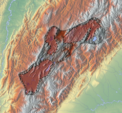
 Outcrops of the Paja Formation near Villa de Leyva | |
The Paja Formation (Spanish: Formación Paja, K1p, Kip, Kimp, b3b6p) is an Early Cretaceous geologic formation of central Colombia. The formation extends across the northern part of the Altiplano Cundiboyacense, the Western Colombian emerald belt and surrounding areas of the Eastern Ranges of the Colombian Andes. In the subsurface, the formation is found in the Middle Magdalena Valley to the west. The Paja Formation stretches across four departments, from north to south the southernmost Bolívar Department, in Santander, Boyacá and the northern part of Cundinamarca. Well known fossiliferous outcrops of the formation occur near Villa de Leyva, also written as Villa de Leiva, and neighboring Sáchica.
The formation was named after Quebrada La Paja in Betulia, Santander, and stretches across 450 kilometres (280 mi) from northeast to southwest. The Paja Formation overlies the Ritoque and Rosablanca Formations and is overlain by the and the and and dates from the late Hauterivian to late Aptian. The Paja Formation comprises mudstones, shales and nodules of sandstones and limestones, deposited in an anoxic environment, in the warm and shallow sea that covered large parts of the present Colombian territory during the Cretaceous.
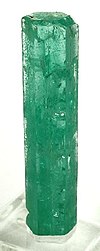
Initially considered to host Colombian emeralds, the emerald-bearing part was redefined as a separate formation; the . The Paja Formation Lagerstätte[1] is famous for its vertebrate fossils and is the richest Mesozoic fossiliferous formation of Colombia. Several marine reptile fossils of plesiosaurs, pliosaurs, ichthyosauras and turtles have been described from the formation and it hosts the only dinosaur fossils described in the country to date; Padillasaurus. The formation also has provided many ammonites, fossil flora, decapods and the fossil shark Protolamna ricaurtei.
Description[]
The Paja Formation was first described by O.C. Wheeler, according to Morales (1958),[2] and named after , a tributary of the Sogamoso River. The type section is exposed on the northern banks of the quebrada at the confluence of the Sogamoso River in Betulia, Santander.[3][4]
The formation is divided into the Lutitas Negras Inferiores, Arcillolitas Abigarradas and Arcillolitas con Nódulos Huecos Members, and stretches across 450 kilometres (280 mi) from northeast to southwest. The Paja Formation overlies the Ritoque and Rosablanca Formations and is overlain by the and and dates from the Hauterivian to Late Aptian.
Outcrops[]

The type section of the Paja Formation is found at the banks of Quebrada La Paja in Betulia, Santander, where the formation has a thickness of 625 metres (2,051 ft).[5] Outcrops of the formation extend from Simití in the north, close to the border of Santander and Bolívar, where the formation is offset by the ,[6] to the Pauna Anticlinal in San Pablo de Borbur, where the formation is thrusted over the Ritoque Formation in the south.[7] In the southern extension of the exposures, the formation crops out in the north of Tununguá, near the .[8]
- Santander
In the Middle Magdalena Valley, south of Barrancabermeja, the Paja Formation in the subsurface is offset by the , and .[9] In the northeastern extent, in , near the border with Norte de Santander, the formation is found in the subsurface, offset by the .[10] The town center of Zapatoca rests on the formation in the synclinal named after the village.[4] The Paja Formation also crops out in the northwestern part of the Middle Magdalena Valley, east of San Pablo, Bolívar, where in the formation underlies the and is offset in the subsurface by the and .[11] South of there, the Paja Formation is offset by the and ,[12] and the regional .[13] Near the , the formation is offset by the .[14]
West of Barichara, the formation underlies the corregimiento and is found in the hills bordering both sides of the Suárez River.[15] In this area, the Paja Formation is offset by the Suárez Fault.[16] Surrounding Jordán, Santander, the formation crops out on both sides of the Chicamocha River in the Chicamocha Canyon. The touristic town San Gil rests on the formation and the cuts into it. East of the town center, the formation is offset by the and .[15] The urban centers of Oiba, San Benito, Encino, Ocamonte and Charalá are built on top of the Paja Formation. In this area, the formation is offset by the and .[17] Further to the south, the towns of Vélez, Guavatá and Jesús María rest on the formation. West of the latter, the Paja Formation is put in a reverse faulted contact with the .[18] The puts the Paja Formation in contact with the Jurassic Girón Formation.[16]
- Boyacá
In northeastern Boyacá, the formation underlies the urban center of Moniquirá (not to be confused with Monquirá, a vereda of nearby Villa de Leyva) and is crossed by the .[18] West of Arcabuco in the Villa de Leyva Synclinal, the formation is cut by the .[19] In the vicinity of Pauna and San Pablo de Borbur, the formation crops out in an extensive area. Here, the Paja Formation is offset by the and and occurs in the footwall of the .[20] North of Lake Fúquene, the town centers of Tinjacá and Sutamarchán are built on top of the Paja Formation. In this area, the formation extends into the northern part of Cundinamarca,[7] where the urban centers of Yacopí and La Palma rest on the formation.[21]
Villa de Leyva[]
Surrounding the touristic town of Villa de Leyva, the formation crops out in the hills in a microclimatic location, known as the La Candelaria Desert (Spanish: Desierto de La Candelaria), stretching across Villa de Leyva, Santa Sofía and Sáchica.[7][22] Along the highway Tunja-Villa de Leyva, the formation is heavily folded and faulted along a stretch of 500 metres (1,600 ft).[23] In the vicinity of Villa de Leyva, the formation has provided many fossils of marine reptiles, as well as the dinosaur Padillasaurus.
Stratigraphy[]

The Paja Formation overlies the Ritoque and Rosablanca Formations and is concordantly overlain by the and in the eastern extent,[24][25] and the in the northwestern Middle Magdalena Valley.[11] In the Western emerald belt, the contact with the Rosablanca Formation is concordant and abrupt.[26] The total thickness of the formation varies across its extent, but can reach up to 940 metres (3,080 ft).[27]
- Members
The Paja Formation is subdivided into three members, from oldest to youngest:
- Lutitas Negras Inferiores (Lower Black Shales) – a sequence of 340 metres (1,120 ft) of black shales and sandy shales with a segment containing calcareous nodules. The age of this member is estimated at late Hauterivian, based on ammonites analyzed by Fernando Etayo.[28]
- Arcillolitas Abigarradas (Mottled Claystones) – a series of multicolored claystones with abundant calcareous fossiliferous nodules, reaching a thickness of 480 metres (1,570 ft). In the upper 235 metres (771 ft) of this member, intercalations of gypsum occur. The age of the middle member of the Paja Formation is estimated at early Barremian to late Aptian on the basis of ammonites described by Fernando Etayo.[28]
- Arcillolitas con Nódulos Huecos (Claystones with Hollow Nodules) – the upper member of the formation of approximately 174 metres (571 ft) thick consists of yellowish and grey claystones containing hollow nodules. Ammonite analysis has led to an estimated late Aptian age for the member.[27]
In the northern part of the Middle Magdalena Valley, the Paja Formation comprises dark grey to blueish shales, intercalated with grey to yellowish fine-grained sandstones and fossiliferous limestones, locally with a sandy component.[29] Bürgl in 1954 reported beds of tuff in the Paja Formation near Villa de Leyva.[30] Thin section analysis of samples of the Paja Formation has provided insight in the micritic components of the sediments, where three microfacies were recognized; biomicritic wackestones, foraminiferous packstones and sandy biomicritic floatstones containing fragments of echinoderms, bivalves, crinoids and gastropods cemented by hematite.[31]
The Paja Formation correlates with the to the east on the northern Altiplano Cundiboyacense in Boyacá and with the El Peñón Formation pertaining to the Villeta Group to the south in the Eastern Ranges. The formation is laterally equivalent with the black shales of the Fómeque Formation in the eastern part of the Eastern Ranges and the sandstones of Las Juntas Formation in the Sierra Nevada del Cocuy.[24] In the Middle Magdalena Valley to the west, the formation partly overlies and partly is laterally equivalent to the limestones of the Rosablanca Formation. The Paja Formation is diachronous with the Ritoque and Rosablanca Formations.[27] To the northeast of the extent of the formation, it correlates with the upper part of the ,[32] and the lowermost of the .[33]
Paleogeography[]

During deposition of the Paja Formation, the paleo coastline was oriented west-east.[34]
From the late Aptian to early Albian, the area was covered by an extensive carbonate platform, in the extent of the Paja Formation represented by the , and Villeta Group.[35]
Depositional environment[]
The thin section analysis led to the interpretation of a shoreface to lower shoreface environment,[36] in the internal parts of a carbonate platform,[37][38] where transgressions and regressions caused the variations in grain sizes and lithologies.[39] The Barremian to Aptian sequence shows evidence of an overall relative sea level fall with open marine sedimentation in the lowest member and tidal deposits in the upper part of the formation.[40]
One of the longest anoxic intervals of geologic history occurred during the Cretaceous, from about 125 to 80 Ma (early Aptian to early Campanian). During this , there were two spikes, the , dating to the early Aptian (approximately 120 Ma) was active during deposition of the black shales of the Paja Formation.[41] The formation contains three spikes of δ13C, with values above 1.5‰, in the lower, middle to upper and upper Paja Formation.[42] These spikes indicate a global change in the carbon cycle and the preservation of organic matter due to poor oxygenation of sea waters. The cause of these elevated δ13C levels may have been a global increase in volcanic activity.[43]
Mining and petroleum geology[]
The Paja Formation is one of the stratigraphic units cropping out in the Western emerald belt.[44] Mineralization in the formation has been dated on the basis of 40Ar/39Ar analysis of muscovite minerals. In western San Pablo de Borbur, Boyacá, the mineralization dates to the Late Eocene at 36.4 ± 0.1 and 37.3 ± 0.1 Ma.[45] In the northwestern part of Muzo, Boyacá, mineralization happened during the Early Oligocene, at 31.4 ± 0.3 Ma.[46] Previous geologic researchers considered the Paja Formation hosted emeralds,[47] and later definition of the stratigraphy of Colombia separated one of the main emerald formations of Colombia as the contemporaneous Barremian , providing emeralds in the La Pita mine and important .[48]
The Paja Formation is known for its gypsum deposits, which are mined and restricted to Santander.[49] Near Guavatá, the formation hosts sphalerite and malachite and near Otanche, pyrite and galena are found in the formation.[47] In Gámbita, the Paja Formation contains pyrite, galena and chalcopyrite.[50] Other minerals occurring in the Paja Formation, are lead and zinc, around Paime and Yacopí, Cundinamarca.[51]
The Paja Formation is considered a minor source rock in the and the Middle Magdalena Valley, with seal capacity for the underlying Rosablanca Formation reservoir in the latter basin.[52][53] Vitrinite reflectance analysis on samples of the Paja Formation indicate an average value of 0.52 Ro, making the formation a marginal source rock.[54]
Paleontological significance[]

The Paja Formation is the richest Mesozoic fossiliferous formation of Colombia. Fauna of dinosaurs, Padillasaurus, and various marine reptiles, among which plesiosaurs, ichthyosaurs, pliosaurs and turtles make up the vertebrate assemblage. Furthermore, many ammonites, the foraminifer ,[55] decapods, flora and fossil fish have been recovered from the formation. Paja ammonites have been used in the walls and floor of the near Villa de Leyva.
In 2019, turtle expert described a fossil of Desmatochelys padillai who was found with her eggs still inside her.[56]
Within the Arcillolitas Abigarradas Member of the Paja Formation, some horizons preserve abundant wood, which is frequently bored by pseudoplanktonic pholadoid bivalves, commonly referred to as "shipworms" or "piddocks". The presence of wood boring bivalves in Paja Formation seas indicates the continued presence of xylic substrates, and long residence time of floating wood.[1]
The paleontological richness of the formation led to the establishment of a center of investigation; (CIP),[57] two museums; ,[58] and ,[59] and a dinosaur park; Gondava,[60] near Villa de Leyva.
Fossil content[]
Reptiles[]
| Reptiles of the Paja Formation | ||||||
|---|---|---|---|---|---|---|
| Genus | Species | Location | Member | Description | Notes | Image |
| Acostasaurus | A. pavachoquensis | Arcillolitas abigarradas | A pliosaurid with short snout, likely not a brachauchenine |  | ||
| Callawayasaurus | C. colombiensis | Loma La Catalina | Arcillolitas abigarradas | An elasmosaurid plesiosaur, originally classified in Alzadasaurus |  | |
| Desmatochelys | D. padillai | Loma de Monsalve Loma La Catalina |
Arcillolitas abigarradas | A species of the genus Desmatochelys, sea turtles that belongs to the extinct family Protostegidae. Is the oldest known sea turtle, and a specimen was found with eggs still inside her. |  | |
| Monquirasaurus | M. boyacensis | Vereda Monquirá | Arcillolitas abigarradas | A large pliosaurid, initially named "Kronosaurus boyacensis" |  | |
| Leyvachelys | L. cipadi | Loma La Catalina | Arcillolitas abigarradas | A durophagous turtle member of the Sandownidae; is the first record for this group in South America. This species occurs too in the Glen Rose Formation in USA |  | |
| Leivanectes | L. bernadoi | Arcillolitas abigarradas | An elasmosaurid plesiosaur | |||
| Muiscasaurus | M. catheti | Vereda Llanitos | Arcillolitas abigarradas | An ophthalmosaurid ichthyosaur, that it seems have occupied a different ecological niche respect to P. sachicarum | ||
| Padillasaurus | P. leivaensis | La Tordolla | Arcillolitas abigarradas | A brachiosaurid dinosaur, that makes the first record of a terrestrial animal in the area, and the first Cretaceous brachiosaurid known outside from North America |  | |
| Kyhytysuka | K. sachicarum | Sáchica | Arcillolitas abigarradas | A platypterygiine ichthyosaur, relative of P. americanum |  | |
| Sachicasaurus | S. vitae | Sáchica | Arcillolitas abigarradas | A 10 metres (33 ft) subadult pliosaur |  | |
| Stenorhynchosaurus | S. munozi | Loma La Cabrera | Arcillolitas abigarradas | A small pliosaurid, over 3 meters in length. Formerly considered as a close relative of Brachauchenius lucasi from North America | ||
| Teleosauroidea gen. indet. | species indet. | Arcillolitas abigarradas Mb. | Fossils of a member of Teleosauroidea with an estimated body length of 9.6 m, representing the most recent definitive record of Teleosauroidea reported | |||
Ammonites[]


| Ammonites of the Paja Formation | ||
|---|---|---|
| Species | Images | Notes |
| Acanthoptychoceras trumpyi |  |
[76] |
 |
[77] | |
| [78] | ||
 |
[76][79] | |
 |
[80][81] | |
| Crioceratites emerici |  |
[82] |
| Crioceratites leivaensis |  |
[83] |
| Crioceratites tener |  |
[84] |
 |
[85] | |
 |
[86] | |
 |
[87] | |
 |
[88][89] | |
 |
[90] | |
 |
[91] | |
 |
[76][81] | |
 |
[77] | |
 |
[92] | |
 |
[93] | |
 |
[94] | |
 |
[95] | |
 |
[96] | |
 |
[97] | |
| Pseudocrioceras anthulai |  |
[95] |
 |
[80] | |
 |
[98] | |
 |
[76] | |
 |
[76] | |
| Acanthohoplites | [99] | |
| Acrioceras julivertii | [100] | |
| [101] | ||
| Crioceratites portarum | [102] | |
| [103] | ||
| Heinzia (Gerhardtia) veleziensis | [81] | |
| [104] | ||
| [104] | ||
| [104] | ||
| [104] | ||
| Olcostephanus boussingaultii | [105] | |
| [106] | ||
| Pseudohaploceras incertum | [104] | |
| [107] | ||
| [81] | ||
| Dufrenoyia sp. | [108] | |
| [104] | ||
Crustaceans[]
| Crustaceans of the Paja Formation | ||
|---|---|---|
| Species | Image | Notes |
 |
[109] | |
| [110] | ||
| [111] | ||
| [112] | ||
| [113] | ||
Flora[]
| Flora of the Paja Formation | ||
|---|---|---|
| Species | Image | Notes |
 |
[114] | |
 |
[115] | |
Fish[]
Ichnofossils[]
Regional correlations[]
| Age | Paleomap | VMM | Guaduas-Vélez | W Emerald Belt | Villeta anticlinal | Chiquinquirá- Arcabuco |
Tunja- Duitama |
Altiplano Cundiboyacense | El Cocuy | ||||
|---|---|---|---|---|---|---|---|---|---|---|---|---|---|
| Maastrichtian |  |
eroded | Guaduas | ||||||||||
| Guadalupe | |||||||||||||
| Campanian | |||||||||||||
| Oliní | |||||||||||||
| Santonian | - | ||||||||||||
| Coniacian | Oliní | Conejo | Chipaque | ||||||||||
| Loma Gorda | undefined | La Frontera | |||||||||||
| Turonian |  |
Hondita | La Frontera | ||||||||||
| Cenomanian | hiatus | Simijaca | |||||||||||
| Pacho Fm. | Hiló - Pacho | Une | |||||||||||
| Albian |  |
Hiló | Une | ||||||||||
| Capotes - - | |||||||||||||
| Aptian | Capotes | Socotá - El Peñón | Paja | Fómeque | |||||||||
| Paja | Paja | El Peñón | Trincheras | ||||||||||
| La Naveta | |||||||||||||
| Barremian | 
| ||||||||||||
| Hauterivian | Las Juntas | ||||||||||||
| Rosablanca | Ritoque | ||||||||||||
| Valanginian | Ritoque | - Murca | Rosablanca | hiatus | Macanal | ||||||||
| Rosablanca | |||||||||||||
| Berriasian |  |
Guavio | |||||||||||
| Arcabuco | |||||||||||||
| Sources | |||||||||||||
| Ma | Age | Paleomap | Regional events | proximal Llanos | distal Llanos | Environments | Maximum thickness | Petroleum geology | Notes | ||||
|---|---|---|---|---|---|---|---|---|---|---|---|---|---|
| 0.01 | Holocene |  |
Holocene volcanism Seismic activity |
alluvium | Overburden | ||||||||
| 1 | Pleistocene |  |
Pleistocene volcanism Andean orogeny 3 Glaciations |
Soatá Sabana |
Alluvial to fluvial (Guayabo) | 550 m (1,800 ft) (Guayabo) |
[118][119][120][121] | ||||||
| 2.6 | Pliocene |  |
Pliocene volcanism Andean orogeny 3 GABI |
Subachoque | |||||||||
| 5.3 | Messinian | Andean orogeny 3 Foreland |
Marichuela | Honda | [120][122] | ||||||||
| 13.5 | Langhian | Regional flooding | hiatus | Lacustrine (León) | 400 m (1,300 ft) (León) |
Seal | [121][123] | ||||||
| 16.2 | Burdigalian | Miocene inundations Andean orogeny 2 |
Proximal fluvio-deltaic (C1) | 850 m (2,790 ft) (Carbonera) |
Reservoir | [122][121] | |||||||
| 17.3 | Distal lacustrine-deltaic (C2) | Seal | |||||||||||
| 19 | Proximal fluvio-deltaic (C3) | Reservoir | |||||||||||
| 21 | Early Miocene | Pebas wetlands | Barzalosa | Distal fluvio-deltaic (C4) | Seal | ||||||||
| 23 | Late Oligocene |  |
Andean orogeny 1 Foredeep |
Proximal fluvio-deltaic (C5) | Reservoir | [119][122] | |||||||
| 25 | Distal fluvio-lacustrine (C6) | Seal | |||||||||||
| 28 | Early Oligocene | Proximal deltaic-marine (C7) | Reservoir | [119][122][124] | |||||||||
| 32 | Oligo-Eocene | Usme | onlap | Marine-deltaic (C8) | Seal Source |
[124] | |||||||
| 35 | Late Eocene |  |
Coastal (Mirador) | 240 m (790 ft) (Mirador) |
Reservoir | [121][125] | |||||||
| 40 | Middle Eocene | Regadera | hiatus | ||||||||||
| 45 | |||||||||||||
| 50 | Early Eocene | |
Deltaic (Los Cuervos) | 260 m (850 ft) (Los Cuervos) |
Seal Source |
[121][125] | |||||||
| 55 | Late Paleocene | PETM 2000 ppm CO2 |
Bogotá | ||||||||||
| 60 | Early Paleocene | SALMA | Barco | Guaduas | Fluvial (Barco) | 225 m (738 ft) (Barco) |
Reservoir | [118][119][122][121][126] | |||||
| 65 | Maastrichtian | |
KT extinction | Guadalupe | Deltaic-fluvial (Guadalupe) | 750 m (2,460 ft) (Guadalupe) |
Reservoir | [118][121] | |||||
| 72 | Campanian | End of rifting | [121][127] | ||||||||||
| 83 | Santonian | Villeta/Güagüaquí | |||||||||||
| 86 | Coniacian | ||||||||||||
| 89 | Turonian | Cenomanian-Turonian anoxic event | Chipaque | Gachetá | hiatus | Restricted marine (all) | 500 m (1,600 ft) (Gachetá) |
Source | [118][121][128] | ||||
| 93 | Cenomanian | |
Rift 2 | ||||||||||
| 100 | Albian | Une | Une | Caballos | Deltaic (Une) | 500 m (1,600 ft) (Une) |
Reservoir | [122][128] | |||||
| 113 | Aptian | |
Fómeque | Open marine (Fómeque) | 800 m (2,600 ft) (Fómeque) |
Source (Fóm) | [119][121][129] | ||||||
| 125 | Barremian | High biodiversity | Paja | Shallow to open marine (Paja) | 940 m (3,080 ft) (Paja) |
Reservoir | [118] | ||||||
| 129 | Hauterivian | |
Rift 1 | Las Juntas | hiatus | Deltaic (Las Juntas) | 910 m (2,990 ft) (Las Juntas) |
Reservoir (LJun) | [118] | ||||
| 133 | Valanginian | Macanal Rosablanca |
Restricted marine (Macanal) | 2,935 m (9,629 ft) (Macanal) |
Source (Mac) | [119][130] | |||||||
| 140 | Berriasian | Girón | |||||||||||
| 145 | Tithonian | Break-up of Pangea | Arcabuco | Alluvial, fluvial (Buenavista) | 110 m (360 ft) (Buenavista) |
"Jurassic" | [122][131] | ||||||
| 150 | Early-Mid Jurassic |  |
Passive margin 2 | La Quinta | Noreán |
hiatus | Coastal tuff (La Quinta) | 100 m (330 ft) (La Quinta) |
[132] | ||||
| 201 | Late Triassic |  |
[122] | ||||||||||
| 235 | Early Triassic |  |
Pangea | hiatus | "Paleozoic" | ||||||||
| 250 | Permian |  |
|||||||||||
| 300 | Late Carboniferous |  |
Famatinian orogeny | () |
[133] | ||||||||
| 340 | Early Carboniferous | Fossil fish Romer's gap |
Cuche (355-385) |
() |
Deltaic, estuarine (Cuche) | 900 m (3,000 ft) (Cuche) |
|||||||
| 360 | Late Devonian |  |
Passive margin 1 | Río Cachirí (360-419) |
() |
Alluvial-fluvial-reef (Farallones) | 2,400 m (7,900 ft) (Farallones) |
[130][134][135][136][137] | |||||
| 390 | Early Devonian |  |
High biodiversity | Floresta (387-400) |
Shallow marine (Floresta) | 600 m (2,000 ft) (Floresta) |
|||||||
| 410 | Late Silurian | ||||||||||||
| 425 | Early Silurian | hiatus | |||||||||||
| 440 | Late Ordovician |  |
Rich fauna in Bolivia | (450-490) |
() |
||||||||
| 470 | Early Ordovician | First fossils | (>470±22) |
() |
() |
() |
[138][139][140] | ||||||
| 488 | Late Cambrian |  |
Regional intrusions | (490-515) |
() |
() |
(490-590) |
() |
[141][142] | ||||
| 515 | Early Cambrian | Cambrian explosion | [140][143] | ||||||||||
| 542 | Ediacaran |  |
Break-up of Rodinia | pre-Quetame | post-Parguaza | () |
Yellow: allochthonous basement (Chibcha Terrane) Green: autochthonous basement (Río Negro-Juruena Province) |
Basement | [144][145] | ||||
| 600 | Neoproterozoic |  |
Cariri Velhos orogeny | (600-1400) |
pre-Guaviare | [141] | |||||||
| 800 |  |
Snowball Earth | [146] | ||||||||||
| 1000 | Mesoproterozoic |  |
Sunsás orogeny | (1000) |
(1030-1100) |
[147][148][149][150] | |||||||
| 1300 | pre-Ariarí | (1300-1400) |
(1180-1550) |
[151] | |||||||||
| 1400 |  |
pre-Bucaramanga | [152] | ||||||||||
| 1600 | Paleoproterozoic | (1500-1700) |
pre-Garzón | [153] | |||||||||
| 1800 |  |
(1800) |
[151][153] | ||||||||||
| 1950 | pre-Mitú | [151] | |||||||||||
| 2200 | Columbia | ||||||||||||
| 2530 | Archean |  |
[151] | ||||||||||
| 3100 | Kenorland | ||||||||||||
| Sources | |||||||||||||
- Legend
- group
- important formation
- fossiliferous formation
- minor formation
- (age in Ma)
- proximal Llanos (Medina)[note 1]
- distal Llanos (Saltarin 1A well)[note 2]
Panorama[]

See also[]
- Plesiosaur stratigraphic distribution
- Floresta Formation, Devonian fossiliferous formation of the Altiplano Cundiboyacense
- Cerrejón Formation, Paleocene fossiliferous formation of northeastern Colombia
- Honda Group, Miocene Lagerstätte of the Upper Magdalena Valley
- La Amarga Formation, contemporaneous fossiliferous formation of the Neuquén Basin in Argentina
- Cerro Barcino Formation, contemporaneous fossiliferous formation of the Cañadón Asfalto Basin in Argentina
- Río Belgrano Formation, contemporaneous fossiliferous formation of the Austral Basin in Argentina
- Camarillas Formation, contemporaneous fossiliferous formation of the in Spain
Notes[]
References[]
- ^ a b Noé et al., 2018
- ^ Morales, 1958
- ^ Reyes et al., 2006, p.33
- ^ a b Plancha 120, 2010
- ^ Patarroyo & Moreno, 1997, p.30
- ^ Plancha 85, 2006
- ^ a b c Plancha 190, 1998
- ^ Reyes et al., 2006, p.32
- ^ Plancha 119, 2008
- ^ Plancha 97, 2009
- ^ a b Plancha 96, 2006
- ^ Plancha 149, 2008
- ^ Plancha 134, 2008
- ^ Plancha 150, 2008
- ^ a b Plancha 135, 2009
- ^ a b Royero & Clavijo, 2001, p.53
- ^ Plancha 151, 2009
- ^ a b Plancha 170, 2009
- ^ Plancha 171, 2009
- ^ Reyes et al., 2006, p.83
- ^ Plancha 189, 2005
- ^ Plancha 191, 1998
- ^ Moreno & Hincapié, 2010, p.44
- ^ a b Villamil, 2012, p.168
- ^ Royero & Clavijo, 2001, p.31
- ^ Reyes et al., 2006, p.26
- ^ a b c Moreno & Hincapié, 2010, p.26
- ^ a b Moreno & Hincapié, 2010, p.25
- ^ Sarmiento et al., 2015, p.65
- ^ Sarmiento Rojas, 2002, p.56
- ^ Espinel & Hurtado, 2010, p.70
- ^ Royero & Clavijo, 2001, p.29
- ^ Royero & Clavijo, 2001, p.32
- ^ Rivera et al., 2018, p.30
- ^ Villamil, 2012, p.164
- ^ Gaona Narváez et al., 2013
- ^ Espinel & Hurtado, 2010, p.73
- ^ Espinel & Hurtado, 2010, p.89
- ^ Galvis & Valencia, 2009, p.79
- ^ Galvis & Valencia, 2009, p.81
- ^ Moreno & Hincapié, 2010, p.48
- ^ Moreno & Hincapié, 2010, p.63
- ^ Moreno & Hincapié, 2010, p.64
- ^ Reyes et al., 2006, p.82
- ^ Gómez Tapias et al., 2015, p.214
- ^ Gómez Tapias et al., 2015, p.208
- ^ a b Sarmiento Rojas, 2002, p.65
- ^ Reyes et al., 2006, p.106
- ^ Royero & Clavijo, 2001, p.60
- ^ Sarmiento Rojas, 2002, p.66
- ^ Acosta & Ulloa, 2002, p.75
- ^ Mojica et al., 2009, p.22
- ^ Mojica et al., 2009, p.39
- ^ Moreno & Hincapié, 2010, p.74
- ^ Patarroyo Camargo et al., 2009
- ^ a b En Colombia encuentran el primer fósil de una tortuga marina, ¡embarazada! –
- ^ (in Spanish) Centro de Investigaciones Paleontológicas
- ^ (in Spanish) Museo Paleontológico de Villa de Leyva
- ^ (in Spanish) Museo El Fósil
- ^ (in Spanish) Parque Gondava
- ^ Gómez Pérez & Noè, 2017
- ^ Welles, 1962
- ^ Carpenter, 1999
- ^ a b Cadena & Parham, 2015a
- ^ Acosta et al., 1979
- ^ Hampe, 1992
- ^ Cadena, 2015b
- ^ Páramo Fonseca et al., 2019
- ^ Maxwell et al., 2015
- ^ Carballido et al., 2015
- ^ Páramo, 1997
- ^ Páramo Fonseca et al., 2018, p.226
- ^ Hampe, 2005
- ^ Páramo et al., 2016
- ^ Cortés et al., 2019
- ^ a b c d e Patarroyo, 2009, p.19
- ^ a b Kabakadze & Hoedemaeker, 1997, p.66
- ^ Kabakadze & Hoedemaeker, 1997, p.67
- ^ Etayo, 1968b, p.63
- ^ a b Kabakadze & Hoedemaeker, 1997, p.81
- ^ a b c d Patarroyo, 2000, p.154
- ^ Kabakadze & Hoedemaeker, 1997, p.62
- ^ Kabakadze & Hoedemaeker, 1997, p.59
- ^ Kabakadze & Hoedemaeker, 1997, p.61
- ^ Kabakadze & Hoedemaeker, 1997, p.77
- ^ Kabakadze & Hoedemaeker, 1997, p.75
- ^ Kabakadze & Hoedemaeker, 1997, p.80
- ^ Etayo, 1968b, p.54
- ^ Kabakadze & Hoedemaeker, 1997, p.71
- ^ Kabakadze & Hoedemaeker, 1997, p.72
- ^ Kabakadze & Hoedemaeker, 1997, p.74
- ^ Kabakadze & Hoedemaeker, 1997, p.64
- ^ Kabakadze & Hoedemaeker, 1997, p.63
- ^ Kabakadze & Hoedemaeker, 1997, p.82
- ^ a b Kabakadze & Hoedemaeker, 1997, p.68
- ^ Kabakadze & Hoedemaeker, 1997, p.69
- ^ Kabakadze & Hoedemaeker, 1997, p.70
- ^ Kabakadze & Hoedemaeker, 1997, p.78
- ^ Gómez & Salgado, 2017, p.17
- ^ Etayo, 1968b, p.56
- ^ Etayo, 1968b, p.59
- ^ Etayo, 1968b, p.57
- ^ Etayo, 1968b, p.62
- ^ a b c d e f Patarroyo, 1997, p.137
- ^ Etayo, 1968b, p.60
- ^ Etayo, 1968b, p.64
- ^ Patarroyo, 2000, p.152
- ^ Espinel & Hurtado, 2010, p.11
- ^ Luque, 2014
- ^ Karasawa et al., 2014
- ^ Luque et al., 2012, p.411
- ^ Luque et al., 2012, p.408
- ^ Luque, 2015
- ^ Moreno et al., 2007, p.18
- ^ Moreno et al., 2007, p.15
- ^ Carrillo Briceño et al., 2019
- ^ Chaparro et al., 2015
- ^ a b c d e f García González et al., 2009, p.27
- ^ a b c d e f García González et al., 2009, p.50
- ^ a b García González et al., 2009, p.85
- ^ a b c d e f g h i j Barrero et al., 2007, p.60
- ^ a b c d e f g h Barrero et al., 2007, p.58
- ^ Plancha 111, 2001, p.29
- ^ a b Plancha 177, 2015, p.39
- ^ a b Plancha 111, 2001, p.26
- ^ Plancha 111, 2001, p.24
- ^ Plancha 111, 2001, p.23
- ^ a b Pulido & Gómez, 2001, p.32
- ^ Pulido & Gómez, 2001, p.30
- ^ a b Pulido & Gómez, 2001, pp.21-26
- ^ Pulido & Gómez, 2001, p.28
- ^ Correa Martínez et al., 2019, p.49
- ^ Plancha 303, 2002, p.27
- ^ Terraza et al., 2008, p.22
- ^ Plancha 229, 2015, pp.46-55
- ^ Plancha 303, 2002, p.26
- ^ Moreno Sánchez et al., 2009, p.53
- ^ Mantilla Figueroa et al., 2015, p.43
- ^ Manosalva Sánchez et al., 2017, p.84
- ^ a b Plancha 303, 2002, p.24
- ^ a b Mantilla Figueroa et al., 2015, p.42
- ^ Arango Mejía et al., 2012, p.25
- ^ Plancha 350, 2011, p.49
- ^ Pulido & Gómez, 2001, pp.17-21
- ^ Plancha 111, 2001, p.13
- ^ Plancha 303, 2002, p.23
- ^ Plancha 348, 2015, p.38
- ^ Planchas 367-414, 2003, p.35
- ^ Toro Toro et al., 2014, p.22
- ^ Plancha 303, 2002, p.21
- ^ a b c d Bonilla et al., 2016, p.19
- ^ Gómez Tapias et al., 2015, p.209
- ^ a b Bonilla et al., 2016, p.22
- ^ a b Duarte et al., 2019
- ^ García González et al., 2009
- ^ Pulido & Gómez, 2001
- ^ García González et al., 2009, p.60
Bibliography[]
- Geology
- ; ; , and . 2018. Rampa mixta dominada por tormentas: modelo depositacional de la sucesión de black shales cretácico de la cuenca Cordillera Oriental, Colombia. 14. 29–30. Accessed 2019-03-12.
- ; ; , and . 2015. Catálogo de dataciones radiométricas de Colombia en ArcGIS y Google Earth. Servicio Geológico Colombiano. Accessed 2019-03-12.
- ; , and . 2015. Evolución Geológica y Estratigrafía del Sector Norte del Valle Medio del Magdalena. 12. 51–82. Accessed 2019-03-12.
- ; , and . 2013. Geochemistry, palaeoenvironments and timing of Aptian organic-rich beds of the Paja Formation (Curití, Eastern Cordillera, Colombia). Geological Society, London, Special Publications 382. 31–48. Accessed 2019-03-12.
- . 2012. Chronology Relative Sea Level History and a New Sequence Stratigraphic Model for Basinal Cretaceous Facies of Colombia, 161–216. Society for Sedimentary Geology (SEPM).
- , and . 2010. Petrografía y análisis facial de las rocas calcáreas aflorantes de la sección Tunja-Villa de Leiva (Boyacá) (BSc. thesis), 1–102. Universidad de Caldas. Accessed 2019-03-12.
- , and . 2010. Estudio de isótopos de carbono (delta 13C) y estroncio (87Sr/86Sr) en los depósitos cretáceos-terciarios de la Cordillera Oriental, 1–181. Universidad de Caldas. Accessed 2017-05-03.
- , and . 2009. Contribución en la determinación de los posibles paleoambientes de las rocas Cretáceas Tempranas sobre la vía Tunja-Villa de Leyva (entre Alto del Arrayán – Peaje Sáchica) y sectores aledaños, departamento de Boyacá (BSc. thesis), 1–127. Universidad de Caldas. Accessed 2019-03-12.
- ; , and . 2009. Cuencas Catatumbo, Cesar – Ranchería, Cordillera Oriental, Llanos Orientales, Valle Medio y Superior del Magdalena, 1–65. . Accessed 2019-03-12.
- ; ; ; ; ; , and . 2006. Geología del cinturón esmeraldífero occidental Planchas 169, 170, 189, 190, 1–114. INGEOMINAS. Accessed 2019-03-12.
- . 2002. Condiciones geológicas favorables de las sedimentitas Cretácicas de la Cordillera Oriental de Colombia para la existencia de depósitos exhalativos submarinos de plomo y zinc. Boletín de Geología 24. 49–72. Accessed 2019-03-12.
- , and . 2001. Mapa geológico del Departamento de Santander 1:400,000 – Memoria Explicativa, 1–92. INGEOMINAS.
- , and . 2000. Mapa Geológico del Departamento de Boyacá – 1:250,000 – Memoria explicativa, 1–120. INGEOMINAS. Accessed 2019-03-12.
- , and . 1997. Nuevas Consideraciones en torno al Cabeceo del Anticlinal de Arcabuco, en cercanias de Villa de Leyva – Boyacá. 22. 27–34. Accessed 2019-03-12.
- . 1997. Barremiano Inferior en la Base de la Formación Paja, Barichara, Santander – Colombia. 22. 135–138. Accessed 2019-03-12.
- . 1958. General Geology and Oil Occurrences of Middle Magdalena Valley, Colombia, 641–695. AAPG habitat of oil symposium. Accessed 2019-03-12.
- Paleontology
- ; , and . 2019. A new lamniform shark Protolamna ricaurtensis sp. nov. from the Lower Cretaceous of Colombia. Cretaceous Research 95. 336–340. Accessed 2019-03-12.
- ; ; ; ; , and . 2019. An Early Cretaceous teleosauroid (Crocodylomorpha: Thalattosuchia) from Colombia. Ameghiniana in press. .. doi:10.5710/AMGH.26.09.2019.3269
- ; ; , and . 2018. Lower Cretaceous marine boring bivalves, from the Paja Formation Lagerstätte of central Colombia, northern South America, 1. 5th International Palaeontological Congress, Paris. Accessed 2019-03-29.
- ; , and . 2018. A new late Aptian elasmosaurid from the Paja Formation, Villa de Leiva, Colombia. 22. 223–238. Accessed 2019-10-12.
- , and . 2017. Guía para reconocer objetos del patrimonio geológico y paleontológico, 1–44. Servicio Geológico Colombiano. Accessed 2019-03-12.
- , and . 2017. Cranial anatomy of a new pliosaurid Acostasaurus pavachoquensis from the Lower Cretaceous of Colombia, South America. Palaeontographica Abteilung A 310. 5–42. Accessed 2019-03-12.
- ; ; , and . 2016. Stenorhynchosaurus munozi, gen. et sp. nov. a new pliosaurid from the Upper Barremian (Lower Cretaceous) of Villa de Leiva, Colombia, South America. 40. 84–103. Accessed 2019-03-12.
- , and . 2015a. Oldest known marine turtle? A new protostegid from the Lower Cretaceous of Colombia. 32. 1–42. Accessed 2019-03-12.
- . 2015b. The first South American sandownid turtle from the Lower Cretaceous of Colombia. PeerJ 3. e1431. Accessed 2019-03-12.
- ; ; ; ; , and . 2015. A new Early Cretaceous brachiosaurid (Dinosauria, Neosauropoda) from northwestern Gondwana (Villa de Leiva, Colombia). Journal of Vertebrate Paleontology Online edition. e980505. Accessed 2019-03-12.
- ; , and . 2015. Ocurrencia de Teredolites clavatus (Leymerie, 1842) en la Formación Paja (Aptiano) de Colombia, 1–2. Colonia del Sacramento, Uruguay, III Simposio Latinoamericano de Icnología. Accessed 2019-03-12.
- . 2015. The oldest higher true crabs (Crustacea: Decapoda: Brachyura): insights from the Early Cretaceous of the Americas. Palaeontology 58. 251–263. Accessed 2019-03-12.
- ; ; , and . 2015. A new ophthalmosaurid ichthyosaur from the Early Cretaceous of Colombia. Papers in Palaeontology 2. 59–70. Accessed 2019-03-12.
- ; ; , and . 2014. Phylogeny and Classification of Raninoida (Decapoda: Brachyura). Journal of Crustacean Biology 34. 216–272. Accessed 2019-03-12.
- . 2014. A new genus and species of raninoidian crab (Decapoda, Brachyura) from the Lower Cretaceous of Colombia, South America. Scripta Geologica 147. 27–34. Accessed 2019-03-12.
- ; ; ; , and . 2012. The oldest frog crabs (Decapoda: Brachyura: Raninoida) from the Aptian of northern South America. Journal of Crustacean Biology 32. 405–420. Accessed 2019-03-12.
- ; , and . 2009. Foraminíferos bentónicos en el Barremiano inferior de la Formación Paja (Boyacá-Santander, Colombia): Evidencias preliminares de un posible bioevento – Lower Barremian benthic foraminifera on the Paja Formation (BoyacáSantander, Colombia): Preliminary evidences from a possible bioevent. 34. 111–122. Accessed 2019-03-12.
- . 2009. Amonitas de un nivel de alta energía del Barremiano inferior en la Formación Paja de los sectores de Villa de Leyva (Boyacá) y Vélez (Santander). Boletín de Geología 31. 15–21. Accessed 2019-03-12.
- ; , and . 2007. Frenelopsis y Pseudofrenelopsis (Coniferales: Cheirolepidiaceae) en el Cretácico temprano de Colombia. Boletín de Geología 29. 13–19. Accessed 2019-03-12.
- . 2005. Considerations on a Brachauchenius skeleton (Pliosauroidea) from the lower Paja Formation (late Barremian) of Villa de Leyva area (Colombia). Mitteilungen aus dem Museum für Naturkunde in Berlin, Geowissenschaftliche Reihe 8. 37–51. Accessed 2019-03-12.
- . 2000. Distribución de Amonitas del Barremiano de la Formación Paja en el Sector de Villa de Leyva (Boyacá, Colombia). Bioestratigrafía. 25. 149–162. Accessed 2019-03-12.
- . 1998. Platypterygius sachicarum (Reptilia, Ichthyosauria) nueva especie del Cretácico de Colombia. Revista INGEOMINAS 6. 1–12.
- , and . 1997. New and less known Barremian-Albian ammonites from Colombia. Scripta Geologica 114. 57–117. Accessed 2019-03-12.
- . 1992. Ein großwüchsiger Pliosauride (Reptilia:Plesiosauria) aus der Unterkreide (oberes Aptium) von Kolumbien. Courier Forschungsinstitut Senckenberg 145. 1–32.
- ; , and . 1979. Noticia preliminar sobre el hallazgo de un presunto Kronosaurus (Reptilia: Dolichorhynchopidae) en el Aptiano superior de Villa de Leiva, Colombia. Lozania () 28. 1–7.
- . 1968a. El Sistema Cretáceo en la región de Villa de Leiva y zonas próximas. 5. 5–74. Accessed 2019-03-12.
- . 1968b. Apuntaciones acerca de algunas amonitas interesantes del Hauteriviano y del Barremiano de la region de Villa de Leiva (Boyaca, Colombia, S.A.) – Hauterivian and Barremian ammonites from the Villa de Leiva region (Boyaca, Colombia, South America). Boletín de Geología 24. 51–70. Accessed 2019-03-12.
- . 1962. A new species of elasmosaur from the Aptian of Colombia and a review of the Cretaceous plesiosaurs. University of California Publications in Geological Sciences 44. 1–96.
Maps[]
- , and . 2006. Plancha 85 – Simití – 1:100,000, 1. INGEOMINAS. Accessed 2017-06-06.
- , and . 2006. Plancha 96 – Bocas del Rosario – 1:100,000, 1. INGEOMINAS. Accessed 2017-06-06.
- , and . 2009. Plancha 97 – Cáchira – 1:100,000, 1. INGEOMINAS. Accessed 2017-06-06.
- , and . 2008. Plancha 119 – Barrancabermeja – 1:100,000, 1. INGEOMINAS. Accessed 2017-06-06.
- ; ; ; ; , and . 2010. Plancha 120 – Bucaramanga – 1:100,000, 1. INGEOMINAS. Accessed 2017-06-06.
- ; ; ; ; ; ; ; , and . 2008. Plancha 134 – Puerto Parra – 1:100,000, 1. INGEOMINAS. Accessed 2017-06-06.
- ; ; ; ; ; ; ; , and . 2009. Plancha 135 – San Gil – 1:100,000, 1. INGEOMINAS. Accessed 2017-06-06.
- ; ; ; ; ; ; ; , and . 2008. Plancha 149 – Puerto Serviez – 1:100,000, 1. INGEOMINAS. Accessed 2017-06-06.
- ; ; ; ; ; ; ; , and . 2008. Plancha 150 – Cimitarra – 1:100,000, 1. INGEOMINAS. Accessed 2017-06-06.
- . 2009. Plancha 151 – Charalá – 1:100,000, 1. INGEOMINAS. Accessed 2017-06-06.
- , and . 2009. Plancha 170 – Vélez – 1:100,000, 1. INGEOMINAS. Accessed 2017-06-06.
- , and . 2009. Plancha 171 – Duitama – 1:100,000, 1. INGEOMINAS. Accessed 2017-06-06.
- , and . 2009. Plancha 190 – Chiquinquirá – 1:100,000, 1. INGEOMINAS. Accessed 2017-06-06.
- ; , and . 1998. Plancha 191 – Tunja – 1:100,000, 1. INGEOMINAS. Accessed 2017-06-06.
External links[]
| Wikimedia Commons has media related to Paja Formation. |
- (in Spanish) Leyvachelys cipadi, una nueva especie de tortuga sandownidae del Cretácico inferior de Colombia
- (in Spanish) Brachauchenius, un superpredador de los mares cretácicos
Colombian emeralds | |||||
|---|---|---|---|---|---|
| Geology |
|  | |||
| History |
| ||||
| Main mining areas |
| ||||
| Individual mines |
| ||||
| Individual emeralds (ct) |
| ||||
| Related articles |
| ||||
| |||||


- Paja Formation
- Geologic formations of Colombia
- Cretaceous Colombia
- Shale formations
- Shallow marine deposits
- Evaporite deposits
- Source rock formations
- Seal rock formations
- Cretaceous paleontological sites of South America
- Mining in Colombia
- Altiplano Cundiboyacense
- Geography of Bolívar Department
- Geography of Boyacá Department
- Geography of Cundinamarca Department
- Geography of Santander Department