Macanal Formation
| Macanal Formation Stratigraphic range: Berriasian-Valanginian ~140–132 Ma PreꞒ
Ꞓ
O
S
D
C
P
T
J
K
Pg
N
| |
|---|---|
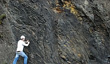 Outcrop of the Macanal Formation along the road between Bogotá and Villavicencio | |
| Type | Geological formation |
| Unit of | |
| Underlies | Las Juntas Formation |
| Overlies | Guavio Fm., , , , |
| Thickness | up to 2,935 m (9,629 ft) |
| Lithology | |
| Primary | |
| Other | Limestone, gypsum, emeralds |
| Location | |
| Coordinates | 4°58′19″N 73°19′10″W / 4.97194°N 73.31944°WCoordinates: 4°58′19″N 73°19′10″W / 4.97194°N 73.31944°W |
| Region | Altiplano Cundiboyacense & Tenza Valley Eastern Ranges Andes |
| Country | |
| Type section | |
| Named for | Macanal |
| Named by | Rodríguez & Ulloa |
| Location | Macanal |
| Year defined | 1979 |
| Coordinates | 4°58′19″N 73°19′10″W / 4.97194°N 73.31944°W |
| Region | Boyacá |
| Country | |

The Macanal Formation or Macanal Shale (Spanish: (Formación) Lutitas de Macanal, Kilm, K1m) is a fossiliferous geological formation of the Altiplano Cundiboyacense and Tenza Valley in the Eastern Ranges of the Colombian Andes. The predominantly formation dates to the Early Cretaceous period; Berriasian to Valanginian epochs and has a maximum thickness of 2,935 metres (9,629 ft). The Macanal Formation contains numerous levels of fossiliferous abundances. Bivalves, ammonites and fossil flora have been found in the formation.
The formation is a source rock for oil and gas in the Eastern Cordillera Basin and adjacent Llanos Basin foothills and provides emeralds in the vicinity of Macanal, after which the formation is named.
Etymology[]
The formation was defined and named in 1979 by Rodríguez and Ulloa after Macanal, Cundinamarca.[1][2] The name Macanal is either derived from the Muysccubun word Macana, meaning garrote, or from the Macana palm tree.[3][4]
Description[]
Lithologies[]

The Macanal Formation has a maximum thickness of 2,935 metres (9,629 ft), and is characterised by a sequence of micaceous ,[2] with calcite veins and gypsum occurrences intercalated in the formation. The Macanal Formation contains high values of TOC.[5] In the and the adjacent foothills of the Llanos Basin, the Macanal Formation is a source rock for oil and gas.[6] In the vicinity of Macanal, the formation provides emeralds.[7][8]
Stratigraphy and depositional environment[]
The Macanal Formation, a unit of the , concordantly overlies the Guavio, , , and ,[9] and is concordantly overlain by the Las Juntas Formation. The age has been estimated to be Berriasian to Valanginian. Stratigraphically, the formation is time equivalent with the , , Rosablanca, Murca and La Naveta Formations.[10] The formation has been deposited in a shallow marine environment in an enclosed basin,[5] with as provenance areas the Santander High and the Guiana Shield.[11] The Macanal Formation is part of the syn-rift sequence of eastern Colombia.[12]
Fossil content[]
The Macanal Formation contains numerous levels of fossiliferous abundances. Bivalves, ammonites and flora have been found in the formation.[13] Ammonites of , , , , Neocomites cf. wichmanni, Olcostephanus sp., Olcostephanus cf. atherstoni, , Acanthodiscus sp. have been registered in the formation, as well as bivalves of , Trigonia cf. hondana, Trigonia (Buchotrigonia) cf. abrupta, Trigonia (Notoscabrotrigonia) cf. tocaimaana, and Exogyra cf. boussingaulti.[14] Analysis of the deformation registered in ammonite fossils has helped in understanding the tectonic history of the Llanos foothills of the Eastern Ranges.[15]
Outcrops[]


The Macanal Formation is apart from its type locality in the canyon,[16][17] found in the Cravo Sur anticline, east of the Ocetá Páramo,[18] in the Desespero Synclinal in the southern and northern parts of Labranzagrande,[19][20] around Páez and Campohermoso,[17] in the eastern part of Gama, bordering the ,[21] and in the Servitá Synclinal, west of Villavicencio.[22] The Macanal Formation crops out along the road between Bogotá and Villavicencio and is there heavily fractured and folded. The Macanal Formation is the most extensive formation around Cáqueza,[23] and Gachalá, Cundinamarca.[24]
The thrusts the Macanal Formation on top of the Fómeque Formation to the east of Lake Tota,[25] and the thrusts the Macanal Formation on top of the overlying Las Juntas Formation around Chámeza, Casanare.[26] The forms the contact between the Fómeque Formation and the Macanal Formation,[27] while the puts the in contact with the Macanal Formation near Quetame,[28] as does the .[29] The forms the contact between the and the Macanal Formation,[30] and the , part of the same system puts the Macanal Formation in contact with the Tertiary .[31] At this contact, brines are extracted from the formation.[32]
Regional correlations[]
| Age | Paleomap | VMM | Guaduas-Vélez | W Emerald Belt | Villeta anticlinal | Chiquinquirá- Arcabuco |
Tunja- Duitama |
Altiplano Cundiboyacense | El Cocuy | ||||
|---|---|---|---|---|---|---|---|---|---|---|---|---|---|
| Maastrichtian |  |
eroded | Guaduas | ||||||||||
| Guadalupe | |||||||||||||
| Campanian | |||||||||||||
| Oliní | |||||||||||||
| Santonian | - | ||||||||||||
| Coniacian | Oliní | Conejo | Chipaque | ||||||||||
| Loma Gorda | undefined | La Frontera | |||||||||||
| Turonian |  |
Hondita | La Frontera | ||||||||||
| Cenomanian | hiatus | Simijaca | |||||||||||
| Pacho Fm. | Hiló - Pacho | Une | |||||||||||
| Albian |  |
Hiló | Une | ||||||||||
| Capotes - - | |||||||||||||
| Aptian | Capotes | Socotá - El Peñón | Paja | Fómeque | |||||||||
| Paja | Paja | El Peñón | Trincheras | ||||||||||
| La Naveta | |||||||||||||
| Barremian | 
| ||||||||||||
| Hauterivian | Las Juntas | ||||||||||||
| Rosablanca | Ritoque | ||||||||||||
| Valanginian | Ritoque | - Murca | Rosablanca | hiatus | Macanal | ||||||||
| Rosablanca | |||||||||||||
| Berriasian |  |
Guavio | |||||||||||
| Arcabuco | |||||||||||||
| Sources | |||||||||||||
| Ma | Age | Paleomap | Regional events | proximal Llanos | distal Llanos | Environments | Maximum thickness | Petroleum geology | Notes | ||||
|---|---|---|---|---|---|---|---|---|---|---|---|---|---|
| 0.01 | Holocene |  |
Holocene volcanism Seismic activity |
alluvium | Overburden | ||||||||
| 1 | Pleistocene |  |
Pleistocene volcanism Andean orogeny 3 Glaciations |
Soatá Sabana |
Alluvial to fluvial (Guayabo) | 550 m (1,800 ft) (Guayabo) |
[33][34][35][36] | ||||||
| 2.6 | Pliocene |  |
Pliocene volcanism Andean orogeny 3 GABI |
Subachoque | |||||||||
| 5.3 | Messinian | Andean orogeny 3 Foreland |
Marichuela | Honda | [35][37] | ||||||||
| 13.5 | Langhian | Regional flooding | hiatus | Lacustrine (León) | 400 m (1,300 ft) (León) |
Seal | [36][38] | ||||||
| 16.2 | Burdigalian | Miocene inundations Andean orogeny 2 |
Proximal fluvio-deltaic (C1) | 850 m (2,790 ft) (Carbonera) |
Reservoir | [37][36] | |||||||
| 17.3 | Distal lacustrine-deltaic (C2) | Seal | |||||||||||
| 19 | Proximal fluvio-deltaic (C3) | Reservoir | |||||||||||
| 21 | Early Miocene | Pebas wetlands | Barzalosa | Distal fluvio-deltaic (C4) | Seal | ||||||||
| 23 | Late Oligocene |  |
Andean orogeny 1 Foredeep |
Proximal fluvio-deltaic (C5) | Reservoir | [34][37] | |||||||
| 25 | Distal fluvio-lacustrine (C6) | Seal | |||||||||||
| 28 | Early Oligocene | Proximal deltaic-marine (C7) | Reservoir | [34][37][39] | |||||||||
| 32 | Oligo-Eocene | Usme | onlap | Marine-deltaic (C8) | Seal Source |
[39] | |||||||
| 35 | Late Eocene |  |
Coastal (Mirador) | 240 m (790 ft) (Mirador) |
Reservoir | [36][40] | |||||||
| 40 | Middle Eocene | Regadera | hiatus | ||||||||||
| 45 | |||||||||||||
| 50 | Early Eocene | |
Deltaic (Los Cuervos) | 260 m (850 ft) (Los Cuervos) |
Seal Source |
[36][40] | |||||||
| 55 | Late Paleocene | PETM 2000 ppm CO2 |
Bogotá | ||||||||||
| 60 | Early Paleocene | SALMA | Barco | Guaduas | Fluvial (Barco) | 225 m (738 ft) (Barco) |
Reservoir | [33][34][37][36][41] | |||||
| 65 | Maastrichtian | |
KT extinction | Guadalupe | Deltaic-fluvial (Guadalupe) | 750 m (2,460 ft) (Guadalupe) |
Reservoir | [33][36] | |||||
| 72 | Campanian | End of rifting | [36][42] | ||||||||||
| 83 | Santonian | Villeta/Güagüaquí | |||||||||||
| 86 | Coniacian | ||||||||||||
| 89 | Turonian | Cenomanian-Turonian anoxic event | Chipaque | Gachetá | hiatus | Restricted marine (all) | 500 m (1,600 ft) (Gachetá) |
Source | [33][36][43] | ||||
| 93 | Cenomanian | |
Rift 2 | ||||||||||
| 100 | Albian | Une | Une | Caballos | Deltaic (Une) | 500 m (1,600 ft) (Une) |
Reservoir | [37][43] | |||||
| 113 | Aptian | |
Fómeque | Open marine (Fómeque) | 800 m (2,600 ft) (Fómeque) |
Source (Fóm) | [34][36][44] | ||||||
| 125 | Barremian | High biodiversity | Paja | Shallow to open marine (Paja) | 940 m (3,080 ft) (Paja) |
Reservoir | [33] | ||||||
| 129 | Hauterivian | |
Rift 1 | Las Juntas | hiatus | Deltaic (Las Juntas) | 910 m (2,990 ft) (Las Juntas) |
Reservoir (LJun) | [33] | ||||
| 133 | Valanginian | Macanal Rosablanca |
Restricted marine (Macanal) | 2,935 m (9,629 ft) (Macanal) |
Source (Mac) | [34][45] | |||||||
| 140 | Berriasian | Girón | |||||||||||
| 145 | Tithonian | Break-up of Pangea | Arcabuco | Alluvial, fluvial (Buenavista) | 110 m (360 ft) (Buenavista) |
"Jurassic" | [37][46] | ||||||
| 150 | Early-Mid Jurassic |  |
Passive margin 2 | La Quinta | Noreán |
hiatus | Coastal tuff (La Quinta) | 100 m (330 ft) (La Quinta) |
[47] | ||||
| 201 | Late Triassic |  |
[37] | ||||||||||
| 235 | Early Triassic |  |
Pangea | hiatus | "Paleozoic" | ||||||||
| 250 | Permian |  |
|||||||||||
| 300 | Late Carboniferous |  |
Famatinian orogeny | () |
[48] | ||||||||
| 340 | Early Carboniferous | Fossil fish Romer's gap |
Cuche (355-385) |
() |
Deltaic, estuarine (Cuche) | 900 m (3,000 ft) (Cuche) |
|||||||
| 360 | Late Devonian |  |
Passive margin 1 | Río Cachirí (360-419) |
() |
Alluvial-fluvial-reef (Farallones) | 2,400 m (7,900 ft) (Farallones) |
[45][49][50][51][52] | |||||
| 390 | Early Devonian |  |
High biodiversity | Floresta (387-400) |
Shallow marine (Floresta) | 600 m (2,000 ft) (Floresta) |
|||||||
| 410 | Late Silurian | ||||||||||||
| 425 | Early Silurian | hiatus | |||||||||||
| 440 | Late Ordovician |  |
Rich fauna in Bolivia | (450-490) |
() |
||||||||
| 470 | Early Ordovician | First fossils | (>470±22) |
() |
() |
() |
[53][54][55] | ||||||
| 488 | Late Cambrian |  |
Regional intrusions | (490-515) |
() |
() |
(490-590) |
() |
[56][57] | ||||
| 515 | Early Cambrian | Cambrian explosion | [55][58] | ||||||||||
| 542 | Ediacaran |  |
Break-up of Rodinia | pre-Quetame | post-Parguaza | () |
Yellow: allochthonous basement (Chibcha Terrane) Green: autochthonous basement (Río Negro-Juruena Province) |
Basement | [59][60] | ||||
| 600 | Neoproterozoic |  |
Cariri Velhos orogeny | (600-1400) |
pre-Guaviare | [56] | |||||||
| 800 |  |
Snowball Earth | [61] | ||||||||||
| 1000 | Mesoproterozoic |  |
Sunsás orogeny | (1000) |
(1030-1100) |
[62][63][64][65] | |||||||
| 1300 | pre-Ariarí | (1300-1400) |
(1180-1550) |
[66] | |||||||||
| 1400 |  |
pre-Bucaramanga | [67] | ||||||||||
| 1600 | Paleoproterozoic | (1500-1700) |
pre-Garzón | [68] | |||||||||
| 1800 |  |
(1800) |
[66][68] | ||||||||||
| 1950 | pre-Mitú | [66] | |||||||||||
| 2200 | Columbia | ||||||||||||
| 2530 | Archean |  |
[66] | ||||||||||
| 3100 | Kenorland | ||||||||||||
| Sources | |||||||||||||
- Legend
- group
- important formation
- fossiliferous formation
- minor formation
- (age in Ma)
- proximal Llanos (Medina)[note 1]
- distal Llanos (Saltarin 1A well)[note 2]
See also[]
 Geology of the Eastern Hills
 Geology of the Ocetá Páramo
 Geology of the Altiplano Cundiboyacense
Notes and references[]
Notes[]
References[]
- ^ Acosta & Ulloa, 2002, p.51
- ^ Jump up to: a b Rodríguez & Solano, 2000, p.47
- ^ (in Spanish) Official website Macanal
- ^ (in Spanish) Etymology Municipalities Boyacá
- ^ Jump up to: a b Acosta & Ulloa, 2002, p.52
- ^ García González et al., 2009, p.49
- ^ Uribe, 1960, p.5
- ^ ANM, 2015, p.1
- ^ Terraza et al., 2013, p.110
- ^ Villamil, 2012, p.168
- ^ Villamil, 2012, p.165
- ^ Schütz, 2012, p.26
- ^ Patiño et al., 2011, p.45
- ^ Piraquive et al., 2011, p.204
- ^ Montaña Cárdenas, 2015, p.52
- ^ Rodríguez & Solano, 2000, p.46
- ^ Jump up to: a b Plancha 210, 2010
- ^ Plancha 172, 1998
- ^ Plancha 193, 1992
- ^ Pinto Valderrama et al., 2010, p.44
- ^ Plancha 228, 1998
- ^ Plancha 266, 1998
- ^ Patiño et al., 2011, p.44
- ^ Terraza et al., 2013, p.101
- ^ Plancha 192, 1998
- ^ Plancha 211, 2009
- ^ Patiño et al., 2011, p.102
- ^ Patiño et al., 2011, p.110
- ^ Patiño et al., 2011, p.114
- ^ Patiño et al., 2011, p.122
- ^ Patiño et al., 2011, p.123
- ^ Patiño et al., 2011, p.125
- ^ Jump up to: a b c d e f García González et al., 2009, p.27
- ^ Jump up to: a b c d e f García González et al., 2009, p.50
- ^ Jump up to: a b García González et al., 2009, p.85
- ^ Jump up to: a b c d e f g h i j Barrero et al., 2007, p.60
- ^ Jump up to: a b c d e f g h Barrero et al., 2007, p.58
- ^ Plancha 111, 2001, p.29
- ^ Jump up to: a b Plancha 177, 2015, p.39
- ^ Jump up to: a b Plancha 111, 2001, p.26
- ^ Plancha 111, 2001, p.24
- ^ Plancha 111, 2001, p.23
- ^ Jump up to: a b Pulido & Gómez, 2001, p.32
- ^ Pulido & Gómez, 2001, p.30
- ^ Jump up to: a b Pulido & Gómez, 2001, pp.21-26
- ^ Pulido & Gómez, 2001, p.28
- ^ Correa Martínez et al., 2019, p.49
- ^ Plancha 303, 2002, p.27
- ^ Terraza et al., 2008, p.22
- ^ Plancha 229, 2015, pp.46-55
- ^ Plancha 303, 2002, p.26
- ^ Moreno Sánchez et al., 2009, p.53
- ^ Mantilla Figueroa et al., 2015, p.43
- ^ Manosalva Sánchez et al., 2017, p.84
- ^ Jump up to: a b Plancha 303, 2002, p.24
- ^ Jump up to: a b Mantilla Figueroa et al., 2015, p.42
- ^ Arango Mejía et al., 2012, p.25
- ^ Plancha 350, 2011, p.49
- ^ Pulido & Gómez, 2001, pp.17-21
- ^ Plancha 111, 2001, p.13
- ^ Plancha 303, 2002, p.23
- ^ Plancha 348, 2015, p.38
- ^ Planchas 367-414, 2003, p.35
- ^ Toro Toro et al., 2014, p.22
- ^ Plancha 303, 2002, p.21
- ^ Jump up to: a b c d Bonilla et al., 2016, p.19
- ^ Gómez Tapias et al., 2015, p.209
- ^ Jump up to: a b Bonilla et al., 2016, p.22
- ^ Jump up to: a b Duarte et al., 2019
- ^ García González et al., 2009
- ^ Pulido & Gómez, 2001
- ^ García González et al., 2009, p.60
Bibliography[]
- , and . 2002. Mapa Geológico del Departamento de Cundinamarca - 1:250,000 - Memoria explicativa, 1–108. INGEOMINAS. Accessed 2017-04-26.
- . 2015. Esmeralda, 1–2. .
- ; ; , and . 2009. Informe Ejecutivo - evaluación del potencial hidrocarburífero de las cuencas colombianas, 1–219. Universidad Industrial de Santander.
- . 2015. Análisis de deformaciones y modelo estructural del frente de deformación del Piedemonte Llanero de la Cordillera Oriental de Colombia (MSc. thesis), 1–57. Universidad Nacional de Colombia. Accessed 2017-08-04.
- ; ; ; ; ; ; ; , and . 2011. Cartografía geológica de la Plancha 247 - Cáqueza - 1:100,000, 1–131. INGEOMINAS. Accessed 2017-08-04.
- ; ; ; ; ; ; , and . 2010. Geología del Piedemonte Llanero en la Cordillera Oriental, departamentos de Arauca y Casanare, 1–64. INGEOMINAS & Universidad Industrial de Santander. Accessed 2017-08-04.
- ; ; ; , and . 2011. Reactivación Neógena de estructuras de rift del Cretácico Temprano asociadas con la Falla de Chámeza, Pajarito, Boyacá (Colombia): evidencias tectónicas y bioestratigráficas. 36. 197–216. Accessed 2017-08-04.
- , and . 2000. Mapa Geológico del Departamento de Boyacá - 1:250,000 - Memoria explicativa, 1–120. INGEOMINAS.
- . 2012. Combined structural and Petroleum Systems Modeling in the Eastern Cordillera Basin, Colombia (MSc. thesis), 1–161. Rheinisch-Westfälische Technische Hochschule Aachen & .
- ; ; ; , and . 2008. Geología del cinturón esmeraldífero oriental - Planchas 210, 228 & 229 - Guateque, Bogotá Noreste & Gachalá - 1:100,000, 1–126. INGEOMINAS. Accessed 2020-03-05.
- ; ; ; ; ; ; ; , and . 2013. Geología de la Plancha 229 - Gachalá - 1:100,000, 1–296. Servicio Geológico Colombiano. Accessed 2017-08-04.
- . 1960. Las esmeraldas de Colombia. Boletín de la Sociedad Geográfica de Colombia XVIII. 1–8. Accessed 2016-07-08.
- . 2012. Chronology Relative Sea Level History and a New Sequence Stratigraphic Model for Basinal Cretaceous Facies of Colombia, 161–216. Society for Sedimentary Geology (SEPM).
Maps[]
- ; , and . 1998. Plancha 172 - Paz de Río - 1:100,000, 1. INGEOMINAS. Accessed 2017-06-06.
- ; , and . 1998. Plancha 192 - Laguna de Tota - 1:100,000, 1. INGEOMINAS. Accessed 2017-06-06.
- . 1992. Plancha 193 - Yopal - 1:100,000, 1. INGEOMINAS. Accessed 2017-06-06.
- ; ; ; , and . 2010. Plancha 210 - Guateque - 1:100,000, 1. INGEOMINAS. Accessed 2017-06-06.
- , and . 2009. Plancha 211 - Tauramena - 1:100,000, 1. INGEOMINAS. Accessed 2017-06-06.
- ; , and . 1998. Plancha 228 - Santafé de Bogotá Noreste - 1:100,000, 1. INGEOMINAS. Accessed 2017-06-06.
- ; , and . 1998. Plancha 266 - Villavicencio - 1:100,000, 1. INGEOMINAS. Accessed 2017-06-06.
External links[]
| Wikimedia Commons has media related to Macanal Formation. |
- ; ; , and . 2015. Plancha 5-09 del Atlas Geológico de Colombia 2015 – escala 1:500,000, 1. Servicio Geológico Colombiano. Accessed 2017-03-16.


| hide | |||||
|---|---|---|---|---|---|
| Geology | 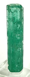 | ||||
| History |
| ||||
| Main mining areas |
| ||||
| Individual mines | |||||
| Individual emeralds (ct) |
| ||||
| Related articles | |||||
| |||||
- Geologic formations of Colombia
- Cretaceous Colombia
- Lower Cretaceous Series of South America
- Berriasian Stage
- Valanginian Stage
- Shale formations
- Shallow marine deposits
- Source rock formations
- Mining in Colombia
- Colombian emeralds
- Fossiliferous stratigraphic units of South America
- Paleontology in Colombia
- Altiplano Cundiboyacense
- Geography of Cundinamarca Department
- Geography of Boyacá Department
- Geography of Casanare Department
- Muysccubun