Etcharry
Etcharry
Etxarri | |
|---|---|
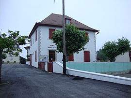 The town hall and school of Etcharry | |
show Location of Etcharry | |
 Etcharry | |
| Coordinates: 43°19′28″N 0°55′37″W / 43.3244°N 0.9269°WCoordinates: 43°19′28″N 0°55′37″W / 43.3244°N 0.9269°W | |
| Country | France |
| Region | Nouvelle-Aquitaine |
| Department | Pyrénées-Atlantiques |
| Arrondissement | Bayonne |
| Canton | Pays de Bidache, Amikuze et Ostibarre |
| Intercommunality | CA Pays Basque |
| Government | |
| • Mayor (2020–2026) | Bernard Casabonne |
| Area 1 | 7.43 km2 (2.87 sq mi) |
| Population (Jan. 2018)[1] | 135 |
| • Density | 18/km2 (47/sq mi) |
| Time zone | UTC+01:00 (CET) |
| • Summer (DST) | UTC+02:00 (CEST) |
| INSEE/Postal code | 64221 /64120 |
| Elevation | 86–227 m (282–745 ft) (avg. 132 m or 433 ft) |
| 1 French Land Register data, which excludes lakes, ponds, glaciers > 1 km2 (0.386 sq mi or 247 acres) and river estuaries. | |


show This article may be expanded with text translated from the corresponding article in French. (December 2008) Click [show] for important translation instructions. |
Etcharry (French pronunciation: [ɛtʃaʁi]; Basque: Etxarri) is a commune in the Pyrénées-Atlantiques department in south-western France.
It is located in the former province of Soule.
See also[]
References[]
- ^ "Populations légales 2018". INSEE. 28 December 2020.
External links[]
| Wikimedia Commons has media related to Etcharry. |
| show Municipalities in Soule |
|---|

This Pyrénées-Atlantiques geographical article is a stub. You can help Wikipedia by . |
Categories:
- Communes of Pyrénées-Atlantiques
- Pyrénées-Atlantiques geography stubs