Heishui County
Coordinates: 32°14′07″N 103°03′20″E / 32.23528°N 103.05556°E
Heishui County
黑水县 • ཁྲོ་ཆུ་རྫོང་། | |
|---|---|
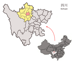
 Location of Heishui County (light red) in Aba (yellow) and Sichuan (light gray) | |
 Heishui Location of the seat in Sichuan | |
| Coordinates: 32°14′07″N 103°03′20″E / 32.23528°N 103.05556°E | |
| Country | People's Republic of China |
| Province | Sichuan |
| Autonomous prefecture | Ngawa Tibetan and Qiang Autonomous Prefecture |
| Area | |
| • Total | 4,356 km2 (1,682 sq mi) |
| Elevation | 3,544 m (11,627 ft) |
| Population (2016)[2] | 61,744 |
| Time zone | UTC+8 (China Standard) |
| Website | www |
Heishui County (Chinese: 黑水县; pinyin: Hēishuǐ Xiàn; lit. 'black water'; Tibetan: ཁྲོ་ཆུ་རྫོང་།, Wylie: khro chu rdzong, ZYPY: Choqu Zong) is a county in the north of Sichuan Province, China. It is under the administration of the Ngawa Tibetan and Qiang Autonomous Prefecture.[3] The county has an area of 1,682 square miles (4,356 km2) and its average elevation is 11,627 feet (3,544 m).[1] As of 2016, the county has a population of 61,744.[2]
Administrative divisions[]
Heishui County has jurisdiction over three towns and 14 townships:[2]
- Luhua Town (芦花镇)
- Kalong Town (卡龙镇)
- Se'ergu Town (色尔古镇)
- Shashiduo Township (沙石多乡)
- Mawo Township (麻窝乡)
- Hongyan Township (红岩乡)
- Shuangliusuo Township (双溜索乡)
- Weigu Township (维古乡)
- Musu Township (木苏乡)
- Luoduo Township (洛多乡)
- Longba Township (龙坝乡)
- Shidiaolou Township (石碉楼乡)
- Wabo Township (瓦钵乡)
- Zhimulin Township (知木林乡)
- Ciba Township (慈坝乡)
- Zhawo Township (扎窝乡)
- Qinglang Township (晴朗乡)
Climate[]
| showClimate data for Heishui (1981−2010) |
|---|
References[]
- ^ Jump up to: a b c Li, Xiguang (2003-01-10). "Prologue". 找故事的艺术——在长征路上体味清华新闻学 [The Art of Storytelling: Experience Tsinghua News on the Long March] (in Chinese). Tsinghua University Press (published 2003-01-01). p. 18. ISBN 9787302062165. Archived from the original on 2017-08-12. Retrieved 2017-08-11.
- ^ Jump up to: a b c Han, Fei; Li, Yaqiong, eds. (2016-03-10). 黑水县情 [Heishui County Overview]. Heishui County Portal (in Chinese). Heishui County Government. Archived from the original on 2017-08-12. Retrieved 2017-08-11.
- ^ 2016年统计用区划代码 [Statistical zoning code, 2016 (Ngawa Tibetan and Qiang Autonomous Prefecture)]. National Bureau of Statistics of the People's Republic of China (in Chinese). National Bureau of Statistics of the People's Republic of China. 2016. Archived from the original on 2017-08-12. Retrieved 2017-08-11.
- ^ 中国地面气候标准值月值(1981-2010) (in Chinese). China Meteorological Data Service Center. Retrieved 20 October 2018.
Categories:
- Ngawa Tibetan and Qiang Autonomous Prefecture
- County-level divisions of Sichuan
- Sichuan geography stubs
