Ibarrolle
Ibarrolle
Ibarrola | |
|---|---|
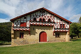 The Etxepare farmhouse | |
 Coat of arms | |
show Location of Ibarrolle | |
 Ibarrolle | |
| Coordinates: 43°12′03″N 1°05′38″W / 43.2008°N 1.0939°WCoordinates: 43°12′03″N 1°05′38″W / 43.2008°N 1.0939°W | |
| Country | France |
| Region | Nouvelle-Aquitaine |
| Department | Pyrénées-Atlantiques |
| Arrondissement | Bayonne |
| Canton | Pays de Bidache, Amikuze et Ostibarre |
| Intercommunality | Pays Basque |
| Government | |
| • Mayor (2014-2020) | Jean-Louis Caset |
| Area 1 | 8.87 km2 (3.42 sq mi) |
| Population (Jan. 2018)[1] | 79 |
| • Density | 8.9/km2 (23/sq mi) |
| Time zone | UTC+01:00 (CET) |
| • Summer (DST) | UTC+02:00 (CEST) |
| INSEE/Postal code | 64267 /64120 |
| Elevation | 159–764 m (522–2,507 ft) (avg. 160 m or 520 ft) |
| 1 French Land Register data, which excludes lakes, ponds, glaciers > 1 km2 (0.386 sq mi or 247 acres) and river estuaries. | |


show This article may be expanded with text translated from the corresponding article in French. (December 2008) Click [show] for important translation instructions. |
Ibarrolle (Basque: Ibarrola) is a commune in the Pyrénées-Atlantiques department in south-western France.
It is located in the former province of Lower Navarre.
Population[]
| Year | Pop. | ±% |
|---|---|---|
| 2006 | 96 | — |
| 2007 | 97 | +1.0% |
| 2008 | 98 | +1.0% |
| 2009 | 98 | +0.0% |
| 2010 | 100 | +2.0% |
| 2011 | 98 | −2.0% |
| 2012 | 95 | −3.1% |
| 2013 | 93 | −2.1% |
| 2014 | 90 | −3.2% |
| 2015 | 88 | −2.2% |
| 2016 | 85 | −3.4% |
See also[]
References[]
- ^ "Populations légales 2018". INSEE. 28 December 2020.
External links[]
| Wikimedia Commons has media related to Ibarrolle. |
This Pyrénées-Atlantiques geographical article is a stub. You can help Wikipedia by . |
Categories:
- Communes of Pyrénées-Atlantiques
- Lower Navarre
- Pyrénées-Atlantiques geography stubs