Karabağlar
Karabağlar | |
|---|---|
District | |
 | |
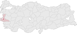 Location of Karabağlar within Turkey. | |
 Karabağlar Location of Karabağlar within Turkey. | |
| Coordinates: 38°22′45″N 27°07′03″E / 38.37917°N 27.11750°E | |
| Country | |
| Region | Aegean |
| Province | İzmir |
| Government | |
| • Type | Municipality |
| • Mayor | Muhittin Selvitopu (Republican People's Party) |
| • Kaymakam | Veysel Özgür |
| Population (2012)[1] | |
| • Urban | 465,120 |
| • District | 466,023 |
| Time zone | UTC+3 (TRT) |
| Postal code | 35XXX |
| Area code(s) | 0232 |
| Licence plate | 35 |
| Website | http://www.karabaglar.bel.tr/ |

Atatürk Hospital in Karabağlar
Karabağlar is a district of İzmir Province of Turkey. It is one of the metropolitan districts of İzmir. Karabağlar was turned into a district by the Cabinet of Turkey on 6 March 2008.
See also[]
References[]
- ^ "Population of province/district centers and towns/villages by districts - 2012". Address Based Population Registration System (ABPRS) Database. Turkish Statistical Institute. Retrieved 2013-02-27.
Karabağlar in Izmir Province of Turkey | |||||||||||||||||||||||||||
|---|---|---|---|---|---|---|---|---|---|---|---|---|---|---|---|---|---|---|---|---|---|---|---|---|---|---|---|
| Districts | 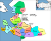 | ||||||||||||||||||||||||||
|
Metropolitan municipalities are bolded. | |||||||||||||||||||||||||||
Known as Smyrna in English until about 1930 | |||||||
| Settlements |
| ||||||
| History |
| ||||||
| Universities | |||||||
| Museums and Monuments |
| ||||||
| Religious buildings |
| ||||||
| Transportation | |||||||
| Buildings and structures | |||||||
| Squares | |||||||
This geographical article about a location in İzmir Province, Turkey is a stub. You can help Wikipedia by . |
Categories:
- Neighbourhoods of İzmir
- Districts of İzmir Province
- Karabağlar District
- Izmir Province geography stubs